User:Rosalinayopeng/Rosalinayopeng13
PAPUA[edit]
[citation needed] "Papua" is the official Indonesian and internationally recognised name for the province. Eastern parts of Papua is the country of Papua New Guinea or East New Guinea. Papua Province covers the western part of Papua, so often referred to as West Papua, particularly by the Free Papua Organization (OPM), the Nationalists who want to secede from Indonesia and form their own country. In the reign of the colonial Dutch East Indies, the area known as Dutch New Guinea (Nederlands Dutch New Guinea or New Guinea).

Province of Papua | |
|---|---|
| Motto(s): Karya Swadaya (Sanskrit) (Work with one's own might) | |
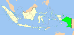
 Location of Province of Papua in Indonesia | |
| Coordinates (Jayapura): 2°32′S 140°43′E / 2.533°S 140.717°E | |
| Country | Indonesia |
| Capital | Jayapura |
| Government | |
| • Governor | Barnabas Suebu |
| Area | |
| • Total | 421,981 km2 (162,928 sq mi) |
| Population (2010) | |
| • Total | 2,900,000 |
| • Density | 6.9/km2 (18/sq mi) |
| Website | www.papua.go.id |
References[edit]
- King, Peter, West Papua Since Suharto: Independence, Autonomy, or Chaos?. University of New South Wales Press, 2004, ISBN 0-86840-676-7.
reflist[edit]
Rosalinayopeng (talk) 07:19, 28 September 2011 (UTC)


