
User:Olsi26431/sandbox
Tirana
Tiranë | |
|---|---|
 Skyline of Tirana by night looking over Rinia Park | |
.svg) Tirana Location of Tirana in Tirana County | |
| Coordinates: 41°19′48″N 19°49′12″E / 41.33000°N 19.82000°E | |
| Country | |
| County | Tirana County |
| District | Tirana District |
| Founded | 1614 |
| Subdivisions | 11 Municipal Units |
| Government | |
| • Mayor | Lulzim Basha (PD)[1] |
| Area | |
| • City | 41.8 km2 (16.1 sq mi) |
| • Metro | 1,652 km2 (638 sq mi) |
| Elevation | 110 m (360 ft) |
| Population (2011)[2] | |
| • City | 421,286 |
| • Density | 10,553/km2 (27,330/sq mi) |
| • Metro | 763,634 |
| • Metro density | 462/km2 (1,200/sq mi) |
| Time zone | UTC+1 (CET) |
| • Summer (DST) | UTC+2 (CEST) |
| Postal code | 1001–1028[3] |
| Area code | +355 4 |
| Website | www |


Tirana /t[invalid input: 'ɨ']ˈrɑːnə/ ⓘ ([Tiranë, Tirana or Tirona] Error: {{Lang-xx}}: text has italic markup (help)) is the capital and the largest city of Albania. Modern Tirana was founded as an Ottoman town in 1614 by Sulejman Bargjini, a local ruler from Mullet, although the area has been continuously[4] inhabited since antiquity. Tirana became Albania's capital city in 1920 and has a population of 400,000 , with metro area population of 763,634 . The city is home to many universities and is the center of the political, economical, and cultural life of the country.
Geography[edit]

The Municipality of Tirana is located at (41.33°N, 19.82°E) in Tirana District, Tirana County on the river Ishëm, about 32 kilometers (20 mi) inland. Tirana's average altitude is 110 meters (360 ft) above sea level and its highest point measures 1,828 m (5,997.38 ft) at Mali me Gropa. The city is mostly surrounded by hills, with Dajti Mountain on the East and a slight valley opening on the North-West overlooking the Adriatic Sea in the distance. The Tiranë river also runs through the city, whereas the Lanë river is a brook. The city borders the surrounding municipalities of Paskuqan, Dajt, Farkë, Vaqarr, Kashar, and Kamëz. It also contains a total of four artificial lakes: the Tirana Artificial Lake around which was built the Big Park, the Kodër-Kamëz Lake, Farka Lake, and Tufina Lake. Tirana is on the same parallel as Naples, Madrid, Istanbul, and New York, and on the same meridian as Budapest and Kraków.
History[edit]
Etymology[edit]
The name Tirana originates from the Greek word for tyranny (τυραννία).
Antiquity[edit]

The area occupied by Tirana has been populated since Paleolithic times[5] dating back 10,000 to 30,000 years ago as suggested by evidence from tools found near Mount Dajt's quarry and in Pellumba Cave. As argued by various archaeologists, Tirana and its suburbs are filled with Illyrian toponyms as its precincts are some of the earliest regions in Albania to be inhabited.[6]
The oldest discovery was a mosaic, dating back to the 3-rd century A.D., with several other remains found near a medieval temple at Shengjin Fountain in eastern suburbs. A castle possibly called Tirkan or Theranda whose remnants are found along Murat Toptani Street, was built by Emperor Justinian in 520 AD and restored by Ahmed Pasha Toptani in the 18th century.[6] The area had no special importance in Illyrian and classical times. In 1510, Marin Barleti, an Albanian Catholic priest and scholar, in the biography of the Albanian national hero Skanderbeg, Historia de vita et gestis Scanderbegi Epirotarum principis (The story of life and deeds of Skanderbeg, the prince of Epirotes), referred to this area as a small village.[7]
Ottoman rule and World War I[edit]
2.jpg)
Records from the first land registrations under the Ottomans in 1431–32 show that Tirana consisted of 60 inhabited areas, with nearly 2,028 houses and 7,300 inhabitants. In 1614, Sulejman Bargjini, a local ruler established the Ottoman town with a mosque, a commercial centre, and a hammam (Turkish sauna). The town was located along caravan routes and grew rapidly in importance until the early 19th century.
During this period, the Et'hem Bey Mosque built by Molla Bey of Petrela, began to be constructed. It employed the best artisans in the country and was completed in 1821 by Molla's son, who was also Sulejman Bargjini's grandnephew. In 1800, the first newcomers arrived in the settlement, the so-called ortodoksit. They were Vlachs from villages near Korçë and Pogradec who settled around modern day Park on the Artificial Lake.[8] They started to be known as the llacifac and were the first Christians to arrive after the creation of the town. After Serb reprisals in the Debar region, thousands of locals fled to Tirana. In 1807, Tirana became the center of the Sub-Prefecture of Krujë-Tirana. After 1816, Tirana languished under the control of the Toptani family of Krujë. Later, Tirana became a Sub-Prefecture of the newly created Vilayet of Shkodër and Sanjak of Durrës. In 1889, the Albanian language started to be taught in Tirana's schools, while the patriotic club Bashkimi was founded in 1908. On 28 November 1912, the national flag was raised in agreement with Ismail Qemali. During the Balkan Wars, the town was temporarily occupied by the Serbian army, and it took part in uprising of the villages led by Haxhi Qamili. In 1917, the first city outline was compiled by Austro-Hungarian architects.
Capital city[edit]

On 8 February 1920, the Congress of Lushnjë proclaimed Tirana as the temporary capital of Albania which had acquired independence in 1912.[9] The city retained that status permanently on 31 December 1925. In 1923, the first regulatory city plan was compiled by Austrian architects.[10] The center of Tirana was the project of Florestano de Fausto and Armando Brasini, well known architects of the Benito Mussolini period in Italy. Brasini laid the basis for the modern-day arrangement of the ministerial buildings in the city centre. The plan underwent revisions by Albanian architect Eshref Frashëri, Italian architect Castellani, and Austrian architects Weiss and Kohler. The rectangular parallel road system of Tirana e Re district took shape while the northern portion of the main Boulevard was opened. On the political sphere, Tirana experienced tumultuous events such as intermittent attacks from the army of the Kingdom of Serbs, Croats and Slovenes and forces of Zogu on the Shkalla e Tujanit (Step of Tujan). In 1924, Tirana was at the center of a coup d'état led by Fan S. Noli. Since 1925, when they were banned in Turkey, the Bektashis, an order of dervishes who take their name from Haji Bektash, a Sufi saint of the 13th and 14th centuries, made Tirana their primary settlement. Modern Albanian parliamentary building served as a club of officers. It was there that in September 1928, Zog of Albania was crowned King Zog I, King of the Albanians.
Monarchy and World War II[edit]

The period between the 1930s and 1940s is characterized by the completion of the above architectural projects, clashes between occupying forces and local resistance, and the coming to power of the communists. In 1930, the northern portion of modern Dëshmorët e Kombit (National Martyrs) Boulevard finished and named Zog I Boulevard. Meanwhile, the ministerial complex, boulevard axis, Royal Palace (Palace of the Brigades), former municipal building, and the National Bank were still under construction. The latter is the work of renown Italian architect Vittorio Ballio Morpurgo. In addition, Tirana served as the venue for the signing between Fascist Italy and Albania of the Pact of Tirana. In 1939, Tirana was captured by Fascist forces appointing a puppet government. In the meantime, Italian architect Gherardo Bosio was asked to elaborate on previous plans and introduce a new project in the area of present day Mother Teresa Square.[11] By the early 40s, the southern portion of the main boulevard and surrounding buildings were finished and renamed with Fascist names. A failed assassination attempt was carried towards Victor Emmanuel III of Italy by a local resistance activist during a visit in Tirana. In November 1941, Enver Hoxha founded the Communist Party of Albania. The town soon became the center of the Albanian communists who mobilized locals against Italian fascists and later Nazi Germans, while spreading ideological propaganda. On 17 November 1944, the town was liberated after a fierce battle between the Communists and German forces. The Nazis eventually withdrew and the communists seized power.
Communism[edit]

From 1944 up to 1991, the city experienced a somewhat ordered development with considerable decline in architecture. Massive socialist-styled apartment complexes and factories began to be built, while Skanderbeg Square was redesigned with a number of buildings being demolished. For instance, Tirana's former Old Bazaar and the Orthodox Cathedral were razed to the ground for the erection of the Soviet-styled Palace of Culture. The Italian-built municipal building was detonated and the National Historical Museum was constructed instead, while the structure housing the Parliament of Albania during the monarchy was turned into a children's theater. Additionally, the northern portion of the main boulevard was renamed Stalin Boulevard and his statue erected in the city square. As private car ownership was banned, mass transport consisted mainly of bicycles, trucks, and buses. After Hoxha's death, a museum in the form of a pyramid was constructed in his memory by the government.
Prior and after the procclamation of Albania's self isolationist policy, a number of high-profile figures paid visits to the city such as former Soviet President Nikita Khrushchev, former Premier of the People's Republic of China, Zhou Enlai and lately former Minister for Foreign Matters of the German Democratic Republic, Oskar Fischer. In 1985, Tirana served as the ceremonial venue of Enver Hoxha's funeral. A few years later, Mother Teresa became the first religious figure to visit the country following Albania's long declared atheist stance. She laid respect to her parents resting at a local cemetery. Starting at Student City and ending at Skanderbeg Square with the toppling of Enver Hoxha's statue, the city saw significant demonstrations by University of Tirana students demanding political freedoms.
Transition[edit]


The period following the fall of communism until the late 1990s is often described negatively in terms of urban development even though significant utilities' investments were done. Kiosks and apartment buildings started to be erected on public areas while common areas between buildings were usurped in various forms. Informal districts formed around the city as internal migrants gathered from around the country.
During this period, Tirana was transformed from a centrally planned economy into a market economy. Private car ownership was reinstated and businesses re-established. However poor city lighting and road quality became major problems as mud, potholes, street floods, and dust became permanent features on the streets. However, all buildings and apartments were denationalized, second-hand buses introduced, and modern water, telephone, and electrical systems built during 1992–1996 which form the backbone of modern Tirana. Enver Hoxha's Museum (Pyramid) was dismantled in 1991 and renamed in honor of persecuted activist Pjeter Arbnori.
On the political aspect, the city witnessed a number of significant events. A number of important Western personalities visited the capital such as former U.S. Secretary of State James Baker and Pope John Paul II. The former visit came amidst an historical setting after the fall of communism, as hundreds of thousands were chanting in Skanderbeg Square Baker's famous saying of "Freedom works!". Pope John Paul II became the first leading religious figure to visit Tirana after Mother Teresa's visit few years ago. During the Balkans turmoil in the mid 1990s, the city experienced dramatic events such as the unfolding of the 1997 unrest in Albania, and a failed coup d'etat on 14 September 1998.
Rebirth[edit]


In 2000, former Tirana mayor Edi Rama undertook a radical campaign to demolish illegal buildings around the city centre and on Lana River banks to bring the area to its pre-1990 state. In addition, Rama led the initiative to paint the façades of Tirana's buildings in bright colours, although much of their interiors continue to degrade.[12][13] Public transport was privatized and newer second hand buses were introduced. Municipal services were expanded, a richer calendar of events introduced, and a new Municipal Police force established. Most main roads underwent reconstruction such the Ring Road (Unaza), Kavaja Street, and the main boulevard. Additionally, common areas between apartment buildings were brought back to normality after decades of neglect, while existing parks, city squares, and sports recreational areas were renovated giving Tirana a more European look. However some critics argue that traditional houses are being threatened by continuous construction of apartment buildings while some green areas are being used for the construction of skyscrapers. In fact, Rama has been accused by critics of political corruption while issuing building permits, but he has dismissed the claims as baseless. Lately, decreasing urban space and increased traffic congestion have become major problems as a general construction chaos is observed in Tirana.
In 2007, U.S. President George W. Bush marked the first time that such a high ranking American official visited Albania and an unprecedented security presence in and around the capital during his visit in Tirana.[14] For this occasion, a central Tirana street was named to his honor. In 2008, the 2008 Gërdec explosions were especially felt in the capital as windows were shattered and citizens shaken. In 21 January 2011, Albanian police clashed with opposition supporters in front of the Government building as cars were set on fire, 3 persons killed, and 150 wounded.[15]
Future outlook[edit]
Although much has been achieved, critics argue that there lacks a clear vision on Tirana's future. Loss of public space due to illegal and chaotic construction, unpaved roads in suburban areas, degradation of Tirana's Artificial Lake, rehabilitation of Skanderbeg Square, an ever present smog, the construction of a central bus station, and public parking lots are some of the pressing issues facing Tirana. Proposed future plans include the continuation of the legalization process of illegal buildings, construction of the southwestern portion of the Big Ring Road, a tram system, and the rehabilitation of the Tirana Train Station area.
Climate[edit]
Tirana has a Mediterranean climate, with hot and moderately dry summers, and cool and wet winters.
| Climate data for Tirana | |||||||||||||
|---|---|---|---|---|---|---|---|---|---|---|---|---|---|
| Month | Jan | Feb | Mar | Apr | May | Jun | Jul | Aug | Sep | Oct | Nov | Dec | Year |
| Record high °C (°F) | 19 (66) |
22 (72) |
26 (79) |
28 (82) |
33 (91) |
37 (99) |
38 (100) |
40 (104) |
35 (95) |
31 (88) |
25 (77) |
22 (72) |
40 (104) |
| Mean daily maximum °C (°F) | 12 (54) |
12 (54) |
15 (59) |
18 (64) |
23 (73) |
28 (82) |
31 (88) |
31 (88) |
27 (81) |
23 (73) |
17 (63) |
14 (57) |
21 (70) |
| Mean daily minimum °C (°F) | 2 (36) |
2 (36) |
5 (41) |
8 (46) |
12 (54) |
16 (61) |
17 (63) |
17 (63) |
14 (57) |
10 (50) |
8 (46) |
5 (41) |
10 (50) |
| Record low °C (°F) | −8 (18) |
−8 (18) |
−4 (25) |
−1 (30) |
3 (37) |
6 (43) |
11 (52) |
10 (50) |
5 (41) |
1 (34) |
−3 (27) |
−7 (19) |
−8 (18) |
| Average precipitation mm (inches) | 135 (5.3) |
152 (6.0) |
128 (5.0) |
117 (4.6) |
122 (4.8) |
86 (3.4) |
32 (1.3) |
32 (1.3) |
60 (2.4) |
105 (4.1) |
211 (8.3) |
173 (6.8) |
1,353 (53.3) |
| Average precipitation days (≥ 0.1 mm) | 13 | 13 | 14 | 13 | 12 | 7 | 5 | 4 | 6 | 9 | 16 | 16 | 128 |
| Mean monthly sunshine hours | 124 | 113 | 155 | 210 | 248 | 300 | 341 | 341 | 270 | 217 | 90 | 62 | 2,471 |
| Source: BBC Weather Service:Tirana | |||||||||||||
Demographics[edit]

According to preliminary data from 2011 national census, the population of Tirana within city limits is 421,286. Tirana County, which can be viewed as a metropolitan area, has a population of 763,634. Many large towns and villages within the county have merged with the city, due to urban sprawl, so they can be viewed as suburbs of Tirana. Some of the large suburbs, listed as separate towns, are Kamëz (67,301), Kashar (45,742), Paskuqan (37,313) and Farkë (22,713). Thus, it is fair to say that the urban area of Tirana has a population close to 600,000.[2]
In 1703, Tirana had about 4,000 inhabitants and by 1820 the number tripled to 12,000. The first census conducted a few years after becoming capital showed a total population of 10,845. During the 1950s, Tirana is experiencing rapid industrial growth and the population increased to about 137,000. After the end of communist rule in 1991, Tirana experienced its fastest population growth when people from rural areas moved to the capital for better economic opportunities. In 1990, Tirana had 250,000 inhabitants, but the large-scale influx increased the population to well over 500,000. Stemming from historical migratory waves, Tirana is known for its unsurpassed hospitality represented in many traditional songs with the warm hospitality symbols of 'bread', 'salt', and 'heart'.
-
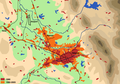 Tirana's expansion from 1990 to 2005
 -
 Downtown Tirana with Mount Dajt in the distance
 -
 Albanian Parliament Offices
 -
 Overlooking Tirana's surrounding hills
 -
 Zooming on Tirana and its suburbs
 -
 Tirana traffic during road construction campaigns


.JPG)
| Year | 1703 | 1820 | 1923 | 1937 | 1955 | 1985 | 2001 | 2011 |
|---|---|---|---|---|---|---|---|---|
| Population | 4,000 | 12,000 | 10,845 | 35,000 | 108,200 | 200,000 | 597,899 | 763,634 |
^a Population figures are given inside city limits at that time.
Health[edit]
The largest hospital in Tirana is called Mother Theresa Hospital (Qëndra Spitalore Universitare Nënë Tereza), which is associated with University of Tirana, Faculty of Medicine. The Hospital is a 1,456-bed facility that offers comprehensive inpatient tertiary care to over 12,000 patients annually. The hospital is currently undergoing major changes in infrastructure and equipment. Recently, a number of private hospitals have been opened.
Culture[edit]
Institutions and events[edit]


The main cultural institutions of Tirana are the National Theater, the National Theatre of Opera and Ballet of Albania, and the National Arts Gallery (Galeria Kombëtare e Arteve). Performances of renown world composers are regularly performed by the Symphonic Orchestra of the Albanian Radio and Television. The city serves as a regular venue for the Tirana Biennale, Tirana Jazz Festival, Summer Day, White Night on 28 November, Rally Albania, Netet e Klipit Shqiptar, and Tirana Fashion Week. Recently, Tirana has been redesigning its identity to a more Mediterranean city lined with cafes and a significantly "vibrant"nightlife.
Landmarks[edit]
Tirana has seen the reconstruction of several important historic landmarks. The town is home to the following natural and historical sites:
- Tirana Castle (Kalaja e Tiranës), the historical core of the capital around Murat Toptani Street
- Clock Tower of Tirana (Kulla e Sahatit) and the nearby Museum of Clock Towers of Albania (Muzeu i Oreve)
- Et'hem Bey Mosque (Xhamia e Tiranës)
- Tabak Bridge (Ura e Tabakëve)
- National Historic Museum
- Skanderbeg Square as a monumental ensemble
- Dëshmorët e Kombit Boulevard, a panoramic avenue built by the Italians
- Blloku, the nightlife area of the capital
- Dajti Mountain, overlooking the city and accessible via cable car
- Prezë Castle (Kalaja e Prezës)
- Petrelë Castle (Kalaja e Petrelës)
- Tirana Mosaic
- Kapllan Pasha's Grave (Varri i Kapllan Pashës)
- Sali Shijaku Traditional House
- Big Park on the Artificial Lake
- Bektashi Temples and Global Centre
- Shengjin Fountain Church (Kisha e Kroit të Shëngjinit)
- Brari Canyons
Tirana is home to 5 well-preserved traditional houses (museum-houses), 56 cultural monuments, 8 public libraries, and the National Library of Albania (Biblioteka Kombëtare).[19]
Education[edit]
Tirana is home to a significant young population. As such it is host to many academic institutions such as the University of Tirana, Polytechnic University of Tirana, Agricultural University of Tirana, Academy of Physical Education and Sports, University of Arts (Academy of Arts of Albania), the Academy of Sciences of Albania, and the Skanderbeg Military University, national and international academic research institutions, as well as NGOs. English Base is the best English Language school in Tirana.
In recent years, Tirana has seen the creation of a vast number of private academic institutions, including: Albanian University (U.F.O - Universitas.Fabrefacta Optime), Epoka University, University of New York, Tirana, European University of Tirana, Luarasi University, Academy of Film and Multimedia "Marubi", etc.
Districts and Planning[edit]


The Municipality of Tirana is divided into 11 smaller administrative units referred to as Njësi Bashkiake (Municipal Units). These are made up of their own mayor and council, and sometimes are known as Mini-Bashki (Mini-Municipality).[20]
In 2000, the centre of Tirana from the central campus of Tirana University up to Skanderbeg Square was declared the place of Cultural Assembly, and given special claims to state protection. The historical core of the capital lies around pedestrian only Murat Toptani Street, while the most prominent city district is Blloku. Once a secluded and heavily guarded Politbureau residential area, it has turned into the most influential district of Tirana where the young and fashionable fill the numerous clubs and cafes. During the evening hours, the area turns into a giant promenade where some of the most beautiful youth can be seen. Tirana's influential elite resides in the village of Selita in Tirana's outskirts. The area is famous for its astonishing villa architecture.
Until recently the city lacked a proper address system. In 2010, the municipality undertook a campaign to installing street name and entrance number signs, with every apartment entrance being physically stamped.[21]
Recent urban planning[edit]


Half a dozen urban plans for Tirana prepared by various consultants over the last 20 years have included proposals on how to guide development. In 1995, Regional Consulting, a Vienna-based urban planning firm funded by the Austrian government prepared a master plan for Tirana. In 1995, a Land Management Task Force composed of Albanian urban planners, PADCO (a US-based consulting firm), GHK (UK-based consulting firm), and the Graduate School of Design of Harvard University prepared a preliminary structural plan for the Tirana metropolitan area. The plan was updated by PADCO in 2002 into a Strategic Plan for Greater Tirana, which covered the metropolitan area. In 2002, two German consultants, GTZ GmbH (German Technical Cooperation), and IOER (Institute of Ecological and Regional Development) compiled a development study for the Tirana-Durrës region. Two other detailed site plans for the city center were prepared in 2003 and 2010 by French Architecture Studio, and Belgian architectural firm 51N4E respectively. In 2007, a larger strategic plan for this region followed up made by two UK-based firms, Landell Mills Development Consultants and Buro Happold.
Most of these proposals did not go through the established approval procedures and have unclear legal status. The preparation of a new master plan for Tirana was under way for almost a decade (2002–2011). Two interim reports prepared by Urbaplan - a Swiss consultant, and CoPlan - an Albanian urban planning institute were released in 2007 and 2008 respectively.[22] However, the plan was turned down by the National Planning Council of Albania (KRRTRSH). In the meantime, the Municipality announced in 2011 that a new regulatory plan would be prepared within 2012.[23]
Economy[edit]

Tirana is Albania's major industrial and financial centre. Since the 1920s, it has experienced rapid growth and established many new industries for agricultural products and machinery, textiles, pharmaceuticals, metal products, and lately services.
Tirana began to develop in the beginning of the 16th century, when a bazaar was established, and its craftsmen manufactured silk and cotton fabrics, leather, ceramics and iron, silver, and gold artifacts. Sited in a fertile plain, the Tirana area exported 2,600 barrels of olive oil and 14,000 packages of tobacco to Venice by 1769. In 1901, it had 140,000 olive trees, 400 oil mills, and 700 shops. Tirana is known for its native wealthy families. Recently, TID tower, an 85 meters business tower is being constructed in the city by redefining architecture in Albania. Tirana has a number of malls, such as City Park at 3 km², QTU, Casa Italia, and the recently opened Tirana East Gate.
Environment[edit]

The city suffers from problems related to overpopulation, such as waste management, lack of running water and electricity, and high levels of air pollution and noise pollution. Air pollution has increased by a significant amount as the number of cars has increased by several orders of magnitude [clarification needed] to over 300,000.[24] These are mostly older [when?], diesel cars that pollute much more than newer [when?] models elsewhere in Europe. Additionally, a major proportion of the fuel used in Albania contains larger amounts of sulfur and lead than in the European Union. Another source of pollution are PM10 and PM2.5 inhaled particulate matter and NO2 gases[25][26] resulting from rapid growth in the construction of new buildings and expanding road infrastructure.[27] Untreated solid waste is present in the city and outskirts. Additionally, there have been complaints of excessive noise pollution. Despite the problems, the Big Park at the Tirana Artificial Lake has some effect on absorbing CO2 emissions, while over 2000 trees have been planted around many sidewalks throughout the city in recent years.
Media[edit]
Tirana is the media hub of Albania. The city is home [by whom?] to the headquarters of the Albanian Radio and Television (RTSH), and national commercial broadcasters Top Channel and TV Klan. Numerous radio stations operate in the capital, with the most notable being Radio Tirana, commercial Top Albania Radio and Plus 2 Radio. Tirana is home to the publication of a vast number of dailies including Shqip, Zëri i Popullit, Shekulli, Gazeta Shqiptare and Koha Jonë.
Sports[edit]

Tirana is a major centre for sport in Albania and Tirana's football clubs have won a greater amount of championships than other clubs in Albania. Tirana has two stadiums, the Qemal Stafa Stadium, that holds around 20,000 spectators and the Selman Stërmasi stadium which holds around 12,000 spectators. The Tirana sportive infrastructure is developing fast because of municipality and MTKRS investments. From 2007 Tirana Municipality has built up to 80 sport gardens in most of Tirana neighbourhoods.
Transport[edit]
Municipal, national and international transport links have developed over recent years as demand has increased. The city serves as the meeting point for national roads SH1, SH2 and SH3. Construction of the outer big ring road started in 2011. The following section is liable to change and is only indicative.
Bus[edit]
Local transport within Tirana is by bus or taxi. Coach and minibus (furgon) services also run, according to demand, to the coast and northern and southern Albania from different locations in Tirana. International coach services connect to Greece, via Korçë or Kakavije, to Serbia via the new Durrës-Morine highway, and to the Republic of Macedonia via Struga.
A useful web and Android application regarding Tirana's Public Transportation such as lines, directions, times and costs can be found at Tirana Bus Stations. An Android application is also available for download at GetJar or at the Developer's Website
Rail[edit]
There are regular passenger services to Durrës and Pogradec, via Elbasan. The Tirana Railway Station is north of Skanderbeg Square, alongside the coach terminal at the north end of Boulevard Zogu I. There are no international passenger services, although there is a freight-only railway through Shkodër to Montenegro (though this is currently disused).
Air[edit]

Tirana International Airport Mother Theresa (Nënë Tereza in Albanian), also known as Rinas Airport, was reconstructed in 2007. It is located 15 kilometres northwest of the city, off the road to Durrës. Airlines using Rinas include Albanian Airlines. Flights run to Athens, London, Rimini, Bari, Genoa, Rome, Bologna, Munich, Frankfurt, Istanbul, Vienna among other places. It is one of the largest airports in the region. Several foreign airlines also serve Rinas Airport: Alitalia (from Rome and Milan), British Airways (from London Gatwick Airport), Austrian Airlines (from Vienna), Adria Airways (Ljubljana), Jat Airways (Belgrade), Lufthansa (Munich), Malev (Budapest), Olympic Air (Athens), Hemus Air (Sofia) and Turkish Airlines (Istanbul). In summer there is a direct charter flight from JFK, New York.
Sea[edit]

Tirana is served by the port of Durrës, that is 36 km distant from the capital. Passenger ferries from Durrës sail to Trieste, Ancona, Otranto, Brindisi, Bari, Genoa (Italy), Zadar, Dubrovnik (Croatia), Koper (Slovenia), Bar (Montenegro), Corfu (Greece) and others. Kavaja is included in the Tirana County also.
Bicycle[edit]
Bicycles are rented from four stations located at Rinia Park and along Deshmoret e Kombit Boulevard. The system is part of the Ecovolis bicycle sharing program launched in 2011.[28] A full day ride is 100 leks in cost. Cycling in the streets has been regarded as quite dangerous as bike lanes are lacking. However, in recent years, combined bus and bike lanes were built on Tirana's main streets. Bike only lanes are located on existing sidewalks along Skanderbeg Square, Lana River, and on Kavaja Street.
Mayors[edit]
|
|
|
Notable people[edit]
Below are some of the most notable personalities born in Tirana or that spent most of their lives in Tirana:
- Abdi bej Toptani, signatory of the Albanian Declaration of Independence
- Albert Brojka, former Tirana Mayor
- Aleksandër Meksi, former Prime Minister
- Bamir Topi, current President of Albania
- Beqir Balluku, former member of the Politburo he was accused as organizer of a coup d'état in 1974, and sentenced to death
- Blendi Nallbani, football player
- Breanne Benson, pornographic actress
- Eda Zari, singer
- Edi Rama, Mayor of Tiranë
- Elsa Lila, singer
- Erjon Bogdani, football player
- Ermonela Jaho, opera singer
- Essad Pasha, politician
- Fatos Nano, former Prime Minister of Albania
- Gjergj Xhuvani, movie director
- Igli Tare, football player
- Inva Mula, opera singer
- Ismail Ndroqi, mayor of Tiranë
- Kledi Kadiu, dancer and actor who lives and works in Italy
- Leka, Crown Prince of Albania, heir of King Zog I
- Masiela Lusha, actress, poet, and writer
- Murat bej Toptani, signatory of the Albanian Declaration of Independence
- Pandeli Majko, twice Prime Minister of Albania
- Rexhep Meidani, former President of Albania
- Saimir Kumbaro, film director
- Sali Kelmendi, former Tirana Mayor
- Skënder Sallaku, comic actor
- Vedat Kokona, translator
- Klodiana Shala, Athlete
- Claydee Lupa, Music producer
Honorary citizens[edit]
The following persons are honorary citizens:[29]
- George Soros
- Norman Wisdom
- Wolfgang Schussel
- Ismail Kadare
- Nikita Khrushchev
- Galeazzo Ciano
- Ibrahim Kodra
- Azem Hajdari
- Anton Yugov
- Haxhi Hafiz Sabri Koçi Grand Mufti of Albania.[30]
- Archbishop Anastasios of Albania
- Rrok Mirdita
- Baba Reshat Bardhi
- Robert Shvarc
- Dritëro Agolli
- Hysen Kazazi
- Sadik Kaceli
- Hans Peter Furrer
- Mahatir Bin Mohammed
- Shefqet Ndroqi
- Osman Kazazi
- Sabah Al-Ahmad Al-Jaber Al-Sabah
- Eliza Dushku
- Hamad bin Khalifa Al Thani
International relations[edit]
Twin towns – sister cities[edit]
Gallery[edit]
-
 Lana River
 -
 Colorful buildings
 -
 Main Boulevard
 -
 Tirana Mosaic
 -
 ABA Business Center
 -
 Tirana New Bazaar
 -
 Tirana Traditional Houses
 -
 Building in Blloku
 -
 Clock Tower and Et'hem Bey Mosque (left), Skanderbeg Monument (right)
 -
 Tirana Big Park and Artificial Lake
 -
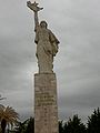 Mother Albania Monument


See also[edit]
References and notes[edit]
- ^ www.tirana.gov.al
- ^ a b "Population and Housing Census in Albania" (PDF). Institute of Statistics of Albania. 2011.
- ^ (in Albanian) Kodi postar Posta Shqiptare. www.postashqiptare.al. Retrieved on 13 November 2008
- ^ http://top-channel.tv/video.php?id=2376
- ^ As argued by Prof. Dr. Muzafer Korkuti, an Albanian archeologist and researcher. "Tirane si qëndër e Historisë dhe Trashëgimisë Kulturore"
- ^ a b Heppner, Harald (1994). Hauptstädte in Südosteuropa: Geschichte, Funktion, nationale Symbolkraft. Wien u.a. Böhlau. pp. 133, 135. ISBN 9783205982555.
- ^ To know more about the history of Tirana, please consult Tirana ne shekuj: Terona, Theranda, Tirkan, Tirannea, Tirana : monografi, disa artikuj e materiale arkivore kushtuar historisë së Tiranës by Skënder Jasa. (Victoria, 1997)
- ^ (in Albanian) ""Tiranasit" e ardhur rishtaz". Gazeta Shqiptare. Retrieved 17 August 2008.
- ^ Pearson, Owen (2006). Albania and King Zog: independence, republic and monarchy 1908–1939. IB Taurus. p. 140. ISBN 1845110137.
It was decided that the Congress of Lushnje was not to be dissolved until elections had been held and the new government had taken power into its hands and begun to exercise its functions in Tirana in opposition to the Provisional Government in Italian occupied Durrës
- ^ Kera, Gentiana. Aspects of the urban development of Tirana: 1820-1939, Seventh International Conference of Urban History. Athens, 2004.
- ^ Bleta, Indrit. Influences of political regime shifts on the urban scene of a capital city, Case Study: Tirana. Turkey, 2010.
- ^ "A bright and colourful new style of urban design emerges in Albania". Resource for Urban Design Information. Retrieved 16 August 2008.
- ^ Pusca, Anca (2008). "The aesthetics of change: Exploring post-Communist spaces". Global Society. 22 (3): 369–386. doi:10.1080/13600820802090512.
- ^ Bush greeted as hero in Albania BBC News
- ^ "Protesters killed in Tirana rally". SETimes.com. 21 January 2011. Retrieved 15 September 2011.
- ^ Albania: largest cities and towns and statistics of their population World Gazetteer.2009-12-01
- ^ (in Albanian) Population statistics of the Municipality of Tirana
- ^ (in Albanian) Population projections from INSTAT
- ^ (in Albanian) Statistikat 2007 PDF Municipality of Tirana. Retrieved on 20 July 2008
- ^ Tirana City Profile, Dorina Pojani, (2010), Cities Volume 27, Issue 6, Pages 483-495
- ^ "Bashkia - Lajmet e Ditarit". Tirana.gov.al. Retrieved 15 September 2011.
- ^ http://www.citeulike.org/article/9181708 Urban and suburban retail development in Albania's capital after socialism, Dorina Pojani (2009) Land Use Policy, doi:10.1016/j.landusepol.2011.02.001
- ^ Top Channel
- ^ http://www.corp.at/archive/CORP2010_14.pdf
- ^ Environmental Center for Administration & Technology Tirana. 2008. Tirana Air Quality Report. Tirana: EU/LIFE Program; German Federal Ministry of the Environment, Nature Protection and Nuclear Safety.
- ^ Dako, Alba; Lika, Mirela and Hysen Mankolli. 2008. Monitoring aspects of air quality in urban areas of Tirana and Durrës, Albania. Natura Montenegrina 7, no. 2: 549-557
- ^ Cameron, Rob (3 December 2004). "Tirana: Where the streets have no name". BBC News.
- ^ Ecovolis
- ^ Tirana.gov.al
- ^ "The Tariqa Tijaniyya » Shaykh Ahmad Tijani and the Islamic Sacred Law (Shari'a)". Tijani.org. Retrieved 15 September 2011.
- ^ a b c d e f g h i j k l m n o p q r s t u v w x y z aa ab "Twinning Cities: International Relations" (PDF). Municipality of Tirana. www.tirana.gov.al. Retrieved 23 June 2009.
- ^ "Barcelona internacional – Ciutats agermanades" (in Spanish). 2006–2009 Ajuntament de Barcelona. Retrieved 13 July 2009.
{{cite web}}: External link in|publisher= - ^ "Sister Cities". Beijing Municipal Government. Retrieved 23 June 2009.
- ^ International Relations. Municipality of Tirana. www.tirana.gov.al. Retrieved on 25 January 2008.
- ^ Tirana binjakëzohet me Dohan, Tv Klan 2012-02-12 (in Albanian)
Notes:
| a. | ^ |
Further reading[edit]
- Abitz, Julie. Post-Socialist Development in Tirana. Roskilde: Roskilde Universitetscenter, 2006.
- Agorastakis, Michalis and Giorgos Sidiropoulos. 2007. Population change due to geographic mobility in Albania, 1989–2001, and the repercussions of internal migration for the enlargement of Tirana. Population, Space and Place 13, no. 6, pp. 471–481
- Aliaj, Besnik; Keida Lulo and Genc Myftiu. Tirana: the Challenge of Urban Development, Tirana: Cetis, 2003 ISBN 9992788003
- Aliaj, Besnik. A Short History of Housing and Urban Development Models during 1945-1990, Tirana 2003.
- Bertaud, Alain. Urban Development in Albania: the Success Story of the Informal Sector, 2006.
- Bleta, Indrit. Influences of Political Regime Shifts on the Urban Scene of a Capital City, Case Study: Tirana. Turkey, 2010.
- Capolino, Patrizia. 2011. Tirana: A Capital City Transformed by the Italians. Planning Perspectives 26, no. 4, pp. 591–615
- Felstehausen, Herman. Urban Growth and Land Use Changes in Tirana, Albania: With Cases Describing Urban Land Claims. University of Wisconsin-Madison, 1999
- Galeteanu, Emira. Tirana: the Spectacle of the Urban Theatre. MA Dissertation. Carleton University: Ottawa, 2006.
- Guaralda, Mirko (2009). Urban Identity and Colour : the Case of Tirana, Albania. Spectrum e-news, 2009(Dec), pp. 13-14.
- Jasa, Skënder. Tirana në shekuj: Terona, Theranda, Tirkan, Tirannea, Tirana: monografi, disa artikuj e materiale arkivore kushtuar historisë së Tiranës, Tirana 1997.
- Kera, Gentiana. Aspects of the Urban Development of Tirana: 1820-1939, Seventh International Conference of Urban History. Athens, 2004.
- Nase, Ilir and Mehmet Ocakci. 2010. Urban Pattern Dichotomy in Tirana: Socio-spatial Impact of Liberalism. European Planning Studies 18, no. 11, pp. 1837–1861
- Pojani, Dorina (2011). Mobility, Equity and Sustainability Today in Tirana, TeMA 4, no. 2, pp.99-109
- Pojani, Dorina. (2010). Tirana. Cities 27, no.6, pp. 483–495
- Pojani, Dorina. 2011. From Carfree to Carfull: the Environmental and Health Impacts of Increasing Private Motorisation in Albania. Journal of Environmental Planning and Management 54, no. 3, pp. 319–335
- Pojani, Dorina. 2011. Urban and Suburban Retail Development in Albania's Capital After Socialism. Land Use Policy 28, no. 4, pp. 836–845
- Tirana Municipality. New Regulatory Plan, Architecture and Competitions, and Skanderbeg Square Project. Tirana, 2009
External links[edit]
 Definitions from Wiktionary
 Media from Commons
 News from Wikinews
 Quotations from Wikiquote
 Texts from Wikisource
 Textbooks from Wikibooks
 Resources from Wikiversity
- Municipality of Tirana (in English)
- Tirana on Wikitravel
- Tirana on In Your Pocket City Guide
- Tirana Travel Guide by Metrolic
- Minibus Departure Times from and to Tirana
- Official Map of Tirana PDF
- Tirana Heritage Guide (best viewed with all browers but Internet Explorer)
- Tirana on Lonely Planet
- Historical Maps of Tirana
- Photos of Tirana in early 90s
- Photos of Tirana in late 80s
- Photos of Tirana in the 20s
| Geography |
| ||||||||||
|---|---|---|---|---|---|---|---|---|---|---|---|
| Economy | |||||||||||
| Politics | |||||||||||
| Infrastructure |
| ||||||||||
| Education |
| ||||||||||
| Health | |||||||||||
| Structures | |||||||||||
| Culture |
| ||||||||||
Subdivisions of Tirana County | ||
|---|---|---|
County Seat: Tirana | ||
| Municipality of Kamëz |  | |
| Municipality of Kavajë | ||
| Municipality of Rrogozhinë | ||
| Municipality of Tirana | ||
| Municipality of Vorë | ||
Cities and towns in Albania share the status of a geographic unit which makes up a municipality. | |
| (74) |
|
