
User:Notorious4life/Unincorporated communities in Michigan

 | This user page is in a state of significant expansion or restructuring. You are welcome to assist in its construction by editing it as well. This template was placed by Notorious4life (talk · contribs). If this user page has not been edited in several days, please remove this template. If you are the editor who added this template and you are actively editing, please be sure to replace this template with {{in use}} during the active editing session. Click on the link for template parameters to use.
This page was last edited by Notorious4life (talk | contribs) 24 days ago. (Update timer) |
This is an essay. It contains the advice or opinions of one or more Wikipedia contributors. This page is not an encyclopedia article, nor is it one of Wikipedia's policies or guidelines, as it has not been thoroughly vetted by the community. Some essays represent widespread norms; others only represent minority viewpoints. |
.jpg)

The following is an essay of my opinions regarding unincorporated communities in Michigan and what constitutes their notability when creating independent articles. The U.S. state of Michigan contains thousands of unincorporated areas, which are colloquially referred to as unincorporated communities (or simply communities).
This essay does not deviate from any commonplace Wikipedia rules or guidelines and merely serves as a suggestion for standardizing, improving, and creating unincorporated community articles within the state of Michigan. It also serves as a basis for creating consistency among the articles and information. If an unincorporated community does not meet the minimal guidelines for a standalone article, it can still be mentioned within its respective township article as a single mention within the township's community section, as well as a redirect to the township article. It can then also be listed in the county article and template under the unincorporated community section.
Definition[edit]
.jpg)
By definition, an unincorporated community in the state of Michigan is a location outside of an incorporated municipality. Simply put, any area outside of an incorporated municipality can be considered a community. Mobile home parks, cookie-cutter subdivisions, three houses at an intersection in the middle of nowhere, apartment complexes, and even grandma's old farmhouse can be loosely defined as a "community" in an unincorporated area. But, there has to be guidelines to ensure that only notable and verifiable communities have a place in Wikipedia.
The state of Michigan recognizes only two forms of incorporated municipalities: cities and villages. Despite what might still appear in some articles, there are no locations defined as a "town" or "hamlet" in the state of Michigan, although these terms do appear sometimes in historical texts. Cities have their own autonomous local government, while villages share these responsibilities with the township(s) in which they are located. Townships—both charter and civil—are defined as "unincorporated" municipalities. Cities, villages, and townships all have defined area and population statistics according to the United States Census Bureau. However, because townships are the only form of unincorporated municipalities, unincorporated communities can only be found within townships. Indian reservations are entirely unique and not discussed, although they have some form of their own legal jurisdiction, even if some of them have portions within an incorporated city or village.
Cities and villages cannot have unincorporated communities within their jurisdiction. Communities within these incorporated municipalities are commonly referred to as neighborhoods. This essay does not address the importance or inclusion of neighborhoods within cities and villages, in which the vast majority are not notable at all unless they are within a major city or part of a designated historic district.
Unincorporated communities do not have any legal recognition as a separate municipality and therefore do not have any defined boundaries or population statistics of their own. They have no tax revenue of their own and do not provide any separate municipal services outside of the township as a whole. Any attempt to include area or population statistics within an unincorporated community article is immediately unverifiable, even if the community itself recognizes a broad area or general number of residents. The only exception to this is unincorporated communities that are also defined by the Census Bureau as a census-designated place (CDP). There are currently 212 census-designated places in Michigan with defined statistics. Not all unincorporated communities are CDPs, but all CDPs are unincorporated communities. Being recognized as a CDP does not give the community any legal autonomy reserved for municipalities.
In some cases, a township or road signage may refer to an unincorporated community as a village, even if it never incorporated throughout its history. Perhaps, they were once informally known as villages in a colloquial sense but never actually became an incorporated municipality. Examples of informal villages may include Scofield, Waltz, and Willow—all of which are described as villages in road signs, historic texts, or township websites but are otherwise unincorporated. To meet state requirements, a village is described in the General Law Village Act of 1895. At that point, maybe some informal villages didn't meet the requirement and abandoned the title; there are also several instances of incorporated villages (and even some cities) losing their municipality status and returning to the control of the township—most notably Au Sable. Former municipal status doesn't apply to incorporated villages and cities that were annexed into surrounding jurisdictions, such as Delray, West Bay City, and more recently Mineral Hills and Stambaugh. These examples are harder to come by, as many communities may have been briefly incorporated villages in the past, and it would take extensive research to find them through old state and census records.
List of unincorporated communities in Michigan article[edit]
With a comprehensive list of unincorporated communities, the questions arises to whether there should be an article named "List of unincorporated communities in Michigan" or not. My answer to that question is definitely yes but not until all the information is organized. Settlements in Michigan currently have the following articles:
- List of municipalities in Michigan — an exhaustive list of all townships, villages, and cities
- Administrative divisions of Michigan — descriptions of the various settlements
- List of census-designated places in Michigan — an article listing the CDPs in the state
- List of counties in Michigan — common article listing the state's counties
- List of ghost towns in Michigan — an article that is in definite need of work
- List of lost cities, towns, and counties of Michigan — an equally garbage article that I intend to boldly remove soon
There are various redirects to the municipality article, as there were once standalone articles that contained lists of individual settlement types. Over discussion, it has been determined that the List of municipalities in Michigan article is acceptable as an enormous list. However, unincorporated communities have been intentionally omitted from any list, as no comprehensive definition or complete list exists. As well as being detailed in their own article if applicable, unincorporated communities are also mentioned in their county articles, within the county templates, and in individual township articles. There certainly are numerous mentions of the uncounted number of unincorporated communities across the Michigan spectrum, but no single article exists detailing a comprehensive list of unincorporated communities.
No real discussion exists pertaining to this topic that I am aware of, so no consensus has ever been reached to agree or disagree on the creation of a "List of unincorporated communities in Michigan" article. Currently, 14 U.S. states have their own articles listing unincorporated communities (see Category:Lists of unincorporated communities in the United States by state). Other states might also list unincorporated communities in other comprehensive articles depending on their own definition of the term. There certainly is precedence that warrants the creation of the Michigan article, but it would be pointless to create an article that is not already prepared and sufficient. When I have completely compiled the list of unincorporated communities in Michigan, it will certainly be a task to undertake with or without a consensus.
Notability criteria[edit]
,_MI.jpg)

Being an unincorporated community does not automatically assume notability for its own independent article. However, there are certain criteria that automatically warrants notability and reason for an independent article. In many cases, an unincorporated community with no standalone article will redirect to the township article, and many communities are listed within their own section within the township article and usually the county template at the bottom of each article. If an unincorporated community has no article (and only a redirect), it does not necessarily mean that the community is not notable; it usually means its own article has not been created.
To meet basic guidelines for notability for a standalone article, an unincorporated community should be included in one or more of the following criteria:
Census-designated places[edit]
Being designated as a census-designated place (CDP) automatically assumes notability. A few former CDPs also exist (such as Greater Galesburg and Quakertown North), and former CDP articles exists for historical purposes. Currently, 15 CDPs do not have their own article, because they are newly included in the 2020 census and haven't been created yet (see this talk page). Also, the K. I. Sawyer CDP doesn't have its own distinct article but is moreover associated and redirected to the K. I. Sawyer Air Force Base article; it will likely never have its own article.
There once was a discussion to whether the defined boundaries and statistics of a CDP are conterminous with the unincorporated community itself, thereby providing defined area and population statistics to an otherwise unincorporated community. My answer to that would be no, which would mean that the name of the CDP and the name of the unincorporated community are not technically the same but are the same for the sake of a single article. For example, the community of Jasper is a census-designated place with an area of 4.03 square miles (10.44 km2) and a population of 412 at the 2010 census. The Jasper 49248 ZIP Code covers a much larger area, but that area itself is also not a definition of the size of the community. It is possible to say that Jasper occupies an area of 4.03 square miles (10.44 km2) as a CDP but otherwise has no defined area as an unincorporated community. It would be redundant to have separate Jasper community and Jasper CDP article, when the single Jasper article can easily discuss both.
Some CDPs have their own post offices which can serve a large area that also includes numerous unincorporated communties. Some CDP post offices actually overlap into a neighboring CDPs, such as portions of the defined boundaries of the Houghton Lake CDP (48629 ZIP Code) serving portions of the defined boundaries of the Prudenville CDP, which also has it's own post office with the 48651 ZIP Code. Some CDPs may have more than one ZIP Code and also be served by other post offices, such as Okemos. Some CDPs may also include a non-CDP unincorporated community that also has its own post office, such as Houghton Lake Heights (48630 ZIP Code) being located within the Houghton Lake CDP. Not all CDPs have their own post offices, and some CDPs are very small and insignificant (such as Pilgrim and Ponshewaing), but their information from the U.S. Census Bureau alone warrants notability.
GNIS identification[edit]
- To search for a GNIS listing, visit here and select "census" and "populated place" for the appropriate state and county.
The Geographic Names Information System lists probably over a million places within the United States, but not every place listed is inherently notable for its own Wikipedia article. In those cases, the GNIS identification number can best be used as a reference in the community section of the township article, in which the unincorporated community redirects. If the only real references available for an unincorporated community consist of GNIS identification numbers, it definitely does not have sufficient information for its own article. After all, the GNIS entry for an unincorporated community typically only lists elevation, coordinates, county, and maybe historic dates and other names for a post office without providing any descriptive information necessary for its own article.
If you search through the extensive list of populated places on the GNIS database, you will notice that there are a lot of places that are entirely unimportant. For example, the Erie Mobile Home Village is located within Erie Township. It has a GNIS identification number and appears to be a sizable community on the map.[1] By its definition, the trailer park is an unincorporated community but certainly does not appear to have any notability for Wikipedia inclusion, as it contains no other viable information. The state of Michigan has tons of trailer parks, while very few have a GNIS identification number. While they can meet the definition of an unincorporated community, I have largely excluded commercial trailer parks from the list of unincorporated communities.
There is a very good chance that an unincorporated community does have its own GNIS identification number due to the sheer volume in the database. In late-2021, the GNIS database underwent a massive reorganization that subsequently deleted GNIS identification numbers and entries for all post offices, historic markers, cemeteries, train stations, some parks, and some geographic features, which I once used as a references in the respective articles. Some of these "retired" GNIS entries are beginning to appear on the Wayback Machine, such as the entry for Reedsburg Dam ([1]). For the most part, I can now use the Romig book for post office information, but any previous citation to defunct GNIS entries is no longer valid. Many old unincorporated communities also contain a historic cemetery that may have at one time had a GNIS entry, but now other references have to be used instead. Many geographic features are still listed on the database, and if they are within close proximity to an unincorporated communty, they can still be used.
Some unincorporated communities also have a Federal Information Processing Standards (FIPS code). If that number can be found, it usually serves no purpose except to mention in the main infobox. I generally do not search for an FIPS code when creating articles for unincorporated communities, because they may not have one, especially if the FIPS Code is the same as the surrounding township.
Current post office and ZIP Code name[edit]

If an unincorporated community has its own post office and ZIP Code, I believe that might be sufficient enough for its own standalone article in some cases. If it has a post office, that means its automatically has a GNIS identification number. However, upon research I found a few exception to that: Beaver Island, Branch, Harsens Island, North Street, Ottawa Lake, and University Center. These post offices do not have a GNIS identification number, but I still define the names as unincorporated communities, as they appear on maps and have numerous other references. There may be more examples, but I don't know yet. The state of Michigan has 1,169 distinct ZIP Codes, but not every ZIP Code has its own individual post office. Some ZIP Codes may also be served by a separate post offices entirely, and some post office may only serve as post office boxes.
A community becomes more notable if it has its own post office name and physical post office building. This can lead to more information for the geography and history sections of the article, as it automatically creates several new references and photo opportunities, even of the post office exists only for P.O. box services (or doesn't actually exist at all anymore). In some cases, the post office might be the only notable structure in the community. If there is a physical post office, I like to include that photo in the main article whenever possible or even include the image in the township article if the community doesn't have it's own article.
Many ZIP Codes also belong to villages and cities, and these ZIP Codes may extend to include the location of an unincorporated community. Of course, every unincorporated community is included in a ZIP Code, even if the post office does not recognize the name of the community for postal service. Some unincorporated communities may also serve an incorporated municipality, such as the Newport 48166 ZIP Code serving the incorporated village of Estral Beach, which never had its own post office.
There are many examples that come to mind of non-CDP unincorporated communities that contain their own ZIP Code name and post office. Some examples with their own articles include Barton City, Comins, Curran, Houghton Lake Heights, Gregory, Luzerne, New Boston, Samaria, Topinabee, Whittaker, and Willis, among many others. When the complete List of unincorporated communities in Michigan article is ready, I plan to mention all the unincorporated communities that have their own post office that uses the same name.
While an unincorporated community may have its own post office and ZIP Code, the area defined by the ZIP Code does not refer to the area and population of the unincorporated community. For example, New Boston is an unincorporated community that has its own post office with the 48164 ZIP Code. The ZIP Code is listed as having an area of 29.54 square miles (76.51 km2) and a population of 9,175.[2] That does not mean that the New Boston community itself has a defined area and population statistics, especially as it is not a CDP. The range of a ZIP Code is not conterminous with an unincorporated community, as the unincorporated community legally has no boundaries. When creating an article for an unincorporated community, it may be possible to list certain landmarks, notable residents, highways, and geographic features if they happen to be within the ZIP Code name of the community. In some cases, I may mention the ZIP Code Tabulation Area if it is large enough. If an unincorporated community's ZIP Code serves a large area including several other townships, it is good information to include.
In some cases, having its own post office does not warrant notability when the unincorporated community lacks its own individual information separate from its township, especially if the two share the same name. It is common for a township to also have an unincorporated community with the same name, such as La Salle, Raber, Riga, and Trout Lake. These examples have their own ZIP Codes that may extend beyond the boundaries of the township, but it might be hard to find separate information for the community that does not already pertain to the township. Unless the community has its own distinct information, it might not be suitable for their own article.
For research and finding information pertaining to ZIP Codes, I usually use the following references, although each one may have slight variations in the size of the ZIP Code range:
- Michigan ZIP Code List – lists all ZIP Codes in the state, as well as their name and map (although the map feature directs you to its location and not an overall area).
- United States ZIP Codes – allows you to see ZIP Codes in a map setting, as well as nearby ZIP Codes, general statistics, purposes, and alternate postal names.
- Google Maps – allows you to see the range of the ZIP Code on a more detailed map; for example, type "48111 zip code" in the search bar, although this isn't mobile friendly.
- Google – a regular Google search can provide a listing of ZIP Codes for an area, which can be cross-referenced with the above websites.
Historic information[edit]
.jpg)
,_Michigan.jpg)
This section discusses unincorporated communities that continue to exist in some present-day form. This section does not include historic communities that no longer exist and can essentially be dubbed as ghost towns (see the below section about former communities for that discussion).
In many cases, an unincorporated community will have some distinguishable history. Notable unincorporated community simply do not pop into existence, and some surviving communities have been around over 150 years but have never incorporated as a municipality. Some may even have a history that predated Michigan's statehood in 1837. Unfortunately, there are many unincorporated communities that lack detailed historical accounts or may be too difficult to locate its sources, which may only be available in archives at local libraries hundreds of miles away. When I write an article for an unincorporated community, I research several common categories of information:
- What is the year of the earliest known settler to the area?
- Does the community have any historic names different from its current name?
- From where and whom did the community receive its former and/or current name?
- If the community had a post office, in what years did it operate and under what different names?
- What was the key economic activity of the historic community, such as lumber, manufacturing, fishing, farming, etc.?
- What were some of the more notable structures in the community's earliest days?
- Does the community have any structures within or nearby that are designated as MSHS or on the NRHP and how might they relate to the community? In some cases, an entire community may be designated as such (e.g. Bay View, Greilickville, and Prudenville).
- Are there historic transportation routes through the community, such as former highways or train stations?
- Are there available historic images (published before January 1, 1928) that can be added to the article?
If I can find verifiable information to answer some of the above questions, the article can begin being written with a detailed history section. If I cannot answer any of these questions with useful information, the community may lack notability and have to redirect back to the township article. Many unincorporated communities seem to have died out over the years but still exist in some form. An important Wikipedia guideline is that notability is not temporary. Just because a community is not as big and important as it used to be doesn't mean that it no longer holds any notability. However, reliable and verifiable information must be available for the article. In some cases, individual township's might have their own detailed history section on their website. For the sake of convenience, I often use web searches, but I do have a few Michigan history books. Learning about new information can allow you to search other topics online that might relate to the community.
Current information[edit]
It will be hard to find an unincorporated community that is identical and frozen in time from when it existed in its earlier heyday. If the community is effectively a ghost town with no residence or remaining structures, many of these questions might only be vaguely answered.
- Is there a current post office? Where is it presently located and what is the ZIP Code area?
- In what school district is the community located? This information is readily available from the state and should be included in every unincorporated community article.
- How does the community differ today from in the past?
- What is the community's area code? (Should only be listed in the infobox)
- Are there any surviving structures from the community's earliest days, such as churches, cemeteries, houses, or schools?
- In what township is the unincorporated community currently located? In some cases, the community might have been part of previous township boundaries, a now-defunct township, a different county at one point, or even part of unorganized, pre-statehood territorial areas.
- What are the main roadways running through or near the community, specifically past or current interstate, U.S. routes, state highways, or county-designated highways?
- What are some of the notable nearby geographic features (lakes, rivers, streams, etc.)?
- What are the names of the nearest other communities in each direction?
If the community has completely disappeared and no questions within this list can be answered, it doesn't mean the community fails notability. In some cases, the historic description of the community can warrant notability; although, it might need to be mentioned that the community has no remaining traces and can be classified as a ghost town.
Former communities[edit]


The state of Michigan has had thousands of historic communities that no longer exist in any form. You might notice one of these communities listed on a map or database and might be curious about its history. At times, historic information may be available for some of these communities, but they are completely gone now. You might track their coordinates and find yourself at a remote and barren roadway where the community once stood. Unless some reliable information can be found for the former community, chances are it is not going to be notable for its own standalone article.
If the only information you can find consists of historic photos, mere mentions in a township history website, or a partial sentence in the Romig book, you might be hard-pressed to gather enough information to create the article. The Category:Ghost towns in Michigan lists dozens of former communities that can be called a ghost town, although there is no solid definition on what counts as a ghost town, as a ghost town may still have permanent residents and original structures. This garbage article, List of ghost towns in Michigan, mentions whatever an editor thinks counts as a ghost town, while some populated communities seem to be listed (e.g. Jennings, Lupton, and South Boardman). I'm not involving myself in the discussion of defining exactly what it means to be a ghost town. When dealing with unincorporated communities in Michigan, the answer is simple. If the community has nothing physically remaining, it is a ghost town. If original or even newer buildings exist and/or the name is still in use, it is a community, especially if it has GNIS identification and appears on modern maps.
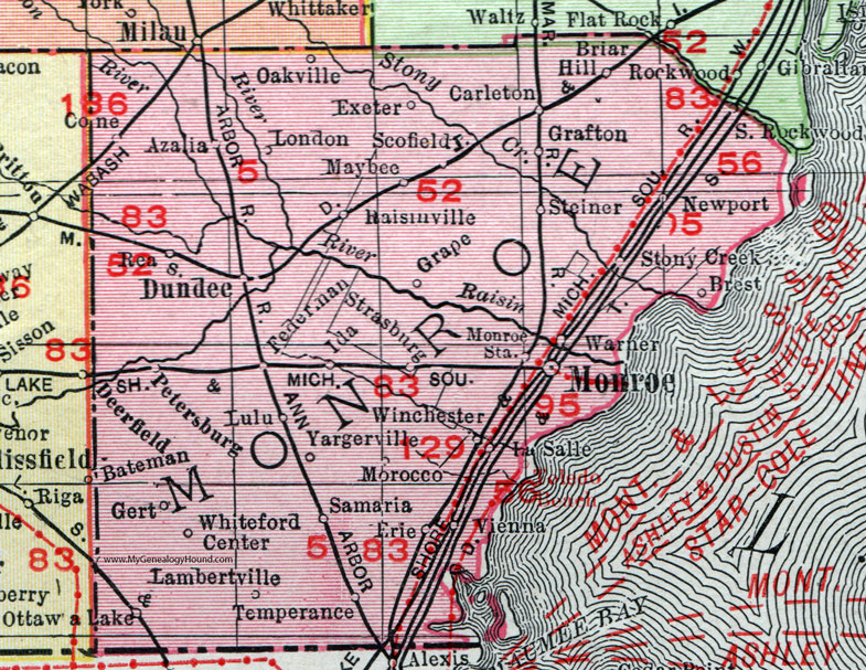
Can a ghost town be referred to as an unincorporated community for categorical purposes? If nothing is left, it can no longer be considered a community. In the case of Steiner, it is categorized as an unincorporated community in Monroe County, as it has a GNIS identification and still appears on maps; Steiner does still appear as a place name on Google Maps. If you drive to its location, the train tracks are still there along with a few newer houses, but no original structures seem to exist. The original Steiner is all gone. However, with many historic communities that still exist, usually nothing from 142 years ago is still standing, but the name continues.
When deciding to create a potential article for a ghost town, many present-day notability criteria from the above section simply cannot be used, so the article has to rely solely on historic information. It all comes down to if the former community has enough published information. If the community appears on the GNIS database, it usually means it can also be categorized as an unincorporated community. While post offices are no longer listed on the GNIS database, the Romig book has detailed dates, although in some cases, it may have an establishment date of the post office and no disestablishment date since the original version of the book is old. If the community has its own GNIS identification number, chances are the community may still exists, even if it now just a cluster of old homes and dirt roads in the middle of nowhere. As I'll say again, an article's creation cannot rely solely on a series of GNIS references. Even GNIS references combined with a Romig reference are still not sufficient. These sources are useful, but if they are all you have to work with, the community would be better off as a mention in a township's community section, even if the community no longer exists. There are many examples of a community be listed as "a former settlement" within a township's article, while using only a Romig reference. The prospective article needs more detailed sources with actual sufficient information, because not all unincorporated communities are notable. Former communities will have a harder time trying to meet basic verifiability and notability guidelines.
Ghost town vs. unincorporated community[edit]
Simply put, if a community has a GNIS identification number, I automatically categorize it as an unincorporated community, even if it appears to be completely gone and uninhabited on a modern map. With very rare exceptions, a community needs a GNIS ID to be categorized as an unincorporated community. The rare exceptions are exclusive only to post office names for unincorporated communities that are not listed on the GNIS database.
If a community does not have a GNIS ID but only appears in the Romig book or other reputable source, I list it as a ghost town and former populated place for categorization purposes. These past communities will not appear in the final List of unincorporated communities in Michigan article and will instead need to be included in the List of ghost towns in Michigan, which is an article I have no interest in at this time.
Failed example scenarios[edit]
These are examples of unincorporated communities that definitely fail most notability requirements for their own standalone article. In fact, there might be so little available information that they are reduced to a single sentence in a township article with a single GNIS ID reference or minimal mention in the Romig book—two main requirements to even be mentioned in the township article. Many previous unincorporated communities may not be annexed into present-day cities, and when that happen, most mention of the past community is irrelevant and not even included in a city's history section.
- Gert: The community of Gert is not listed in the GNIS database. It doesn't have any known coordinates and has no known historic mentions in available sources in Monroe County. The community is so far gone that even its former location is lost, except for its name appearing on a 1911 map of Monroe County, where it appears to be in Whiteford Township. In the Romig book, Gert has one sentence that mentions it had a post office for about 10 years from 1895–1904. Could I create an article that says "Gert is a former community within Monroe County in the U.S. state of Michigan. A post office operated in Gert from 1895–1904." That is all the article would be able to say. Instead, Gert is classified and categorized in Category:Ghost towns in Michigan and Category:Former populated places in Monroe County, Michigan, as it cannot be defined as a present-day unincorporated community. There are many examples of these past communities mentioned in the Romig book, and they can be mentioned briefly in township articles if the location can be determined.
- Tent City: This unusual unincorporated community of Tent City has a GNIS identification number (Tent City). The database lists it as a "populated place" that is defined as "place or area with clustered or scattered buildings and a permanent human population." When you search for Tent City, Google Maps will take you to its location, but you will see that there is absolutely nothing there (Google Maps location). Because of the community's simple name and non-existence, there is absolutely no sources available online to provide any information. It would be pointless to create a Tent City, Michigan article, because it fails both verifiability and notability. In the case of Tent City, a redirect and simple sentence in the township's community section is all you're going to get. If Tent City did exist at one time, it certainly is a ghost town now—a ghost town with no surviving information. It is only listed as an unincorporated community in any capacity because of its GNIS ID. Without being mention on the GNIS database, Tent City may have never existed.
- Tonquish: Tonquish is the name of a post office that existed from 1886–1895, 1900–1903, and as a Wayne branch post office from 1961–1965. Before the former Tonquish post office was removed from the GNIS database along with the rest of the past and current post office listings, the former entry listed the post office coordinates here: Google Maps location. This would place the former Tonquish post office in the far northeast corner of Canton Township, where no community of that name seems to exist in any form. Because of the post office's sporadic existence, was Tonquish the name of an actual community or was it simply the name of a post office serving the surrounding area? Is it similar to a post office named Springwells that currently serves as a branch office for the city of Detroit, as the Springwells post office predates the community's incorporation into Detroit? Any searching simply shows that Tonquish was the name of a Native American chief who is now remembered by a Michigan state historic marker and present-day creek that is also named Tonquish. With no sufficient information, it would be impossible to create a Tonquish, Michigan article or even add useful information as a community in other articles. There is simply no information available to give notability to a short-lived historic post office.
.jpg)
Article construction[edit]
Infobox and structure[edit]
Scofield, Michigan | |
|---|---|
.jpg) Looking west along Scofield Road | |
 Scofield Location within the state of Michigan  Scofield Location within the United States | |
| Coordinates: 42°01′17″N 83°28′55″W / 42.02139°N 83.48194°W | |
| Country | United States |
| State | Michigan |
| County | Monroe |
| Township | Exeter |
| Settled | 1872 |
| Elevation | 630 ft (190 m) |
| Time zone | UTC-5 (Eastern (EST)) |
| • Summer (DST) | UTC-4 (EDT) |
| ZIP code(s) | 48159 (Maybee) |
| Area code | 734 |
| GNIS feature ID | 637454[3] |
For consistency, I have tried to make all unincorporated community articles to appear in the same format—at least the ones that I have created or made edits. Shown here is the infobox for the commmunity of Scofield in Monroe County. It the most basic infobox example, as it is not a census-designated place and does not have its own current post office. For a more expanded infobox that includes a county map, multiple ZIP Codes, dual GNIS identifications, area and population statistics for the CDP, see Winn, Michigan.
I try to make all infoboxes appear in the same format. Merritt is an example of a non-CDP unincorporated community, so there is no boundary map, population, or area statistics that one would see if visiting Edgemont Park or Woodland Beach. Under no circumstances should an unincorporated community list any government information or a URL (unless specifically designated for the community). Mottos or nicknames should only be applied if they are absolutely verifyable, such as Luzerne. For a lead statement in each article, I generally write it in the following manner and leave further information for the following sections:
Willis is an unincorporated community in Washtenaw County in the U.S. state of Michigan.[4] The community is located within Augusta Charter Township. As an unincorporated community, Willis has no legally defined boundaries or population statistics of its own but does have its own post office with the 48191 ZIP Code.[5]
If the unincorporated community does not have its own ZIP Code, I will remove that phrase from the end. I will still include the name of the ZIP Code that serves the community in both the infobox and geography section of the article. Merritt, as seen on the right, is an example of an unincorporated community that is located within more than one township. You might ask, "How can Merritt be in two townships when it has no legally defined area?" Merritt is located along M-55, which is the boundary between Butterfield and Enterprise townships. Even as a non-CDP, it can be assumed that the community extends north and south of M-55 and is therefore in two municipalities. There are several other examples of this; Four Towns and Wexford Corner are extreme examples of communities situated at the corners of four townships, although the latter does not have its own article. Even though Wexford Corner is within four townships, the redirect goes to the township with the most development and associated history but still has a listing in each relevant township.
At a minimum, an unincorporated community article should have a geography and history section. The geography section can be reserved to describe the general location of the community, including elevation, geographic features (rivers and lakes), roadways and major highways, and the nearest other communities. Other mentions can include a library, township hall, fire department, or notable (or old) businesses. This section can also discuss the post office location and ZIP Code information if applicable. The history section can discuss the past post offices with different names, churches, early schools, cemeteries, community founders, significant events, past industries, and possible reasons for the communities decline or continued prosperity. A comprehensive history section is important to illustrate the community's importance. Other general information, such as school districts, nearby airports, local annual events, and images are always useful to add extra information. The more information, the better, as long as it has a verifiable source to warrant its notability.
With few exceptions, no website should ever be mentioned in the infobox or external links. Linking back to the township website should also be avoided, except for direct references within the text. Facebook, YouTube, or other informal personal websites should never be used in any capacity. Copper Harbor and Grand Marais are rare examples of unincorporated communities that have a website listed in their infobox. If an unincorporated community has a verified nickname or motto, it can be listed in the infobox and maybe explained within the article.
Images[edit]
Adding an image to any article automatically seems to make it look more important and professional. I believe that every article should have an image, especially settlement articles. In the case of unincorporated communities, it adds extra content and visuals to an article that might be lacking in substantial information. While unincorporated communities have no defined boundaries, it is usually easy to locate the center of the community, which in most cases is an intersection or cluster of buildings, road signage, or post office.
In the infobox, I always like to have a comprehensive image that best shows the community, which is usually the main intersection of the community (New Boston, Omena, Whittaker) or long-shot of the community along a highway (Comins, Curran, and Tipton). If the center of the community is indistinguishable, a photo of the main geographic feature will sometimes have to suffice (Manitou Beach–Devils Lake, Manistee Lake, Skidway Lake).
.jpg)
If the community has a post office, it can serve as a supplemental image in the article, as can notable structures, such as a fire station, police station, historic markers, cemeteries, etc. I do not like overloading articles with photos, and I think five images is the most I have added to a single unincorporated community (Old Mission).
Vague statements[edit]
As stated before, unincorporated communities do not have legally recognized population statistics or boundaries. Unincorporated communities do have a precise location identified by the coordinates from their GNIS identification listing or from other maps. However, knowing the "center" of the community does not make any indication to its size or population.
Unlike cities that might have a lot more published information, unincorporated communities often seem to be loaded with original research and speculative information. Because the articles may be neglected and rarely updated for some of the most obscure communities, it is important to follow the same guidelines that apply to every other Wikipedia article. Oftentimes, unincorporated communities have very little available sources and are easy to be filled with unencyclopedic information and substandard writing, and their articles may not be widely seen or monitored. The following is a list of general phrases I have often encountered in minor settlement articles. These generally apply to currently existing unincorporated communities and not ghost towns with no remaining structures.
![]() "...currently has a small population of about 100."[a]
"...currently has a small population of about 100."[a]
![]() "...is bounded by the Red River on the north and Twins Highway on the south."[b]
"...is bounded by the Red River on the north and Twins Highway on the south."[b]
![]() "...consists of about seven houses surrounded by farmland."[c]
"...consists of about seven houses surrounded by farmland."[c]
![]() "...is a sleepy town" or "quiet peaceful community."[d]
"...is a sleepy town" or "quiet peaceful community."[d]
![]() "...is a tiny unincorporated community."[e]
"...is a tiny unincorporated community."[e]
![]() "...had an estimated population of about 35 residents from eight families at the turn of the century."[f]
"...had an estimated population of about 35 residents from eight families at the turn of the century."[f]
![]() "...despite its small size, the community continues to prosper and has a positive future."[g]
"...despite its small size, the community continues to prosper and has a positive future."[g]
![]() "...continues to suffer from a loss of businesses and declining population."[h]
"...continues to suffer from a loss of businesses and declining population."[h]
![]() "...suffers from very cold winters and heavy snowfalls."[i]
"...suffers from very cold winters and heavy snowfalls."[i]
- ^ Do not guess the population. It is impossible to determine this, and no estimated population statistics should be listed unless the article is a CDP with verified statistics.
- ^ Unincorporated communities have no defined areas, so you cannot list any potential boundaries that do not exist (unless it is a CDP).
- ^ Listing the precise number of remaining structures serves no purpose, as structures may be abandoned, torn down, or new houses added.
- ^ These are probably the dumbest expressions anyone can use to describe a rural community that has a small population and no economic development.
- ^ Listing unmeasurable adjectives describing the size of the community is often unacceptable, especially in the lead section, as these words are objective and do not have a precise meaning.
- ^ This historic population information may be valuable if it comes from a reliable source and illustrates the size of the community in the past.
- ^ Yes, these kinds of statements exist. While they sound warm and happy, this tone of writing is very unencyclopedic.
- ^ A loss of business and decline in population may not be related. Unless there are direct sources listing the reasons for the community's decline, such as a closing railway or factory, these kinds of statements are mere speculation.
- ^ While this statement is true for many places, climate information for a community can only be listed if it comes from a verified source or weather station. Unincorporated communities usually do not have their own weather statistics.
Wikipedia is not a directory[edit]
If you are familiar with an unincorporated area—either you live there or its a favorite vacation spot—it is important to follow Wikipedia guidelines when it comes to listing local businesses. Wikipedia is not a directory and should not contain an overly detailed description of past or present businesses. Businesses are often changing names, may close seasonally or permanently, and many are simply not notable for mentioning. Nobody should go to Wikipedia to read about local businesses, especially for articles that may not have been updated in years.
Listing the names of historic businesses and companies might be good if it is noteworthy and verifiable; otherwise, a generic listing of the types of former businesses may be good for historic context. For example, "Businesses within Cone included a blacksmith shop, brick and charcoal manufacturers, cheese factory, two churches, several stores, two sawmills, and other manufacturing companies." There is no need to mention the shop as "Uncle Bob's Blacksmith Shop on East 2nd Street" even if that information was available. It overloads the article with useless information about a local business that may have operated for a few years over 100 years ago. Unless the business was noteworthy, such as the founding of a present-day major company or if it actually had a significant role in the community's development, the specific company name and extra details are usually useless.
It is often frowned upon to list specific businesses, and this extends far from settlement articles. It is generally unacceptable to list outlet stores in a mall, animals in a zoo, streets in a neighborhood, restaurants in a downtown area, or specific information about private residents. Today, many unincorporated communities contain very few businesses, but it is acceptable to list them in a generic manner. If the community contains a gas station, bar, and hardware store, it might be acceptable to mention that information. However, it would not be acceptable to say, "The community contains a BP gas station, Tim's Corner Bar, and a True Value hardware store." Even though one can clearly see the gas station on the map and look up its contact information, that information may not be useful on a Wikipedia article.
Common references[edit]
Most of the information I use for unincorporated community articles actually comes from a predetermined list of sources that I have compiled. The majority of them are internet sources, but it is important to have primary sources are well. Generally, when I create a new article, I actually just copy and paste many of the sources if they are applicable. Obviously, there are numerous other references that can be located, such as township website information, local newspaper archives,
Internet sources[edit]
- Geographic Names Information System search is obviously the first source that I look at when researching an unincorporated community. If it does not have a GNIS identification, it probably doesn't count as an unincorporated community for listing purposes. That usually means it is wholly unimportant, may be a ghost town, or the name of a former post office, which disqualifies it as an active community.
- Google Maps is a valuable website for several reasons. It allows you to verify the community's location, as many unincorporated communities will appear by name on the map. The map also provides insight into other nearby communities, roadways, and geographic features. If the community has a ZIP Code, Google Maps also maps out the tabulation area for the ZIP Code, which can be useful to mention in an article.
- UnitedStatesZipCodes.org is basically a supplement to using Google Maps to look up ZIP Code information. Sometimes, the maps are slightly different, but this website provides information regarding postal services (e.g. P.O. Box only) and other acceptable location names for the same ZIP Code.
- Pure Michigan (Michigan Economic Development Corporation) is a state-based website that includes many unincorporated communities. While the information provided is often very brief, it can be used as a simple reference point.
- Michigan Geographic Framework (Monroe County link provided) is the go-to PDF for public school district boundaries. Every unincorporated community article should list the school district(s), and every county has its own PDF map (simply substitute "MONROE" for any county).
- The Historical Marker Database and MichMarkers.com are generic websites that feature photos and text of local and state historic markers. Not every community has a listing, but it can provide some easy historical information.
- Michiganrailroads.com has pretty much every train station that has ever existed in the state of Michigan. While the information is sometimes lacking, it can provide another reference. Many unincorporated communities were founded along historic railways and may still have active depots and railway lines. In some cases, their website has free-use (expired) images from prior to 1920 that can be uploaded to Wikipedia.
- MDOT railway map is a valuable PDF maps that shows the current railway lines in the state, which can be compared with historical railway lines. Some communities still have railway lines, even if they no longer have a station.
- Find A Grave is a massive database for cemeteries, and even some smaller rural communities have listings, images, and information. There are other databases, but this one is the most convenient. When including cemetery information for an unincorporated community, I use this website to verify its location, other names, establishment date, and oldest gravesite. However, Find A Grave has been listed as an unreliable source, as it is also a user-based website. If you cite Find A Grave, a robot may delete your citation but not the actual information in the article. This can simply be avoided by not linking Find A Grave in the citation, and the robot will not recognize it; the Find A Grave external link will still exist in the citation.
- Genealogy Trails is mostly a historic photo album and contains many listings for Michigan communities. The information is sometimes lacking or speculative, but I basically use this website to search for pre-1920 photographs for some communities.
- Michigan's Recreational Boating Information System (MRBIS) is a nice database map that shows Michigan DNR public boating access points. Many waterfront communities might have a boat ramp, and it's a small tidbit of information that can be added to an article.
Primary sources[edit]
I do not own very many useful books that detail the history of the state's smaller communities, although I may expand my library on the subject.
- Romig, Walter (October 1, 1986) [1973]. Michigan Place Names: The History of the Founding and the Naming of More Than Five Thousand Past and Present Michigan Communities (Paperback). Detroit, Michigan: Wayne State University Press. ISBN 978-0-8143-1838-6.
{{cite book}}:|work=ignored (help) - Ray, Dodge (1996) [1973]. Michigan Ghost Towns: Of the Upper Peninsula (formerly Michigan Ghost Towns, Vol. III). Alpena, Michigan: Thunder Bay Press Michigan. ISBN 0932212646.
Disliked sources[edit]
- 99.1 WFMK is a website that appears very frequently when searching for small communities in Michigan. The website contains numerous commercial advertisements, which can be annoying. The information is very simple and often includes text from a township website or basic information from Michigan Place Names, as well as original research and grainy images pasted from Google Maps street view. The website and its associated Facebook page are fun for casual conversations and nostalgia, but that's about it.
List of unincorporated communities[edit]
This list will not be expanded any further, as all information pertaining to unincorporated communities is being organized at User:Notorious4life/sandbox, which will serve as the draft for the List of unincorporated communities in Michigan.
The following is a list of unincorporated communities within the state of Michigan. Being listed below does not assume that the community is notable enough for its own article until further information is gathered. This list may also include communities that no longer exist, as they may still meet the criteria for article creation. Communities listed below that are blue-linked are redirects to a township article and not to a standalone article. Red-linked communities are most likely historic post office locations and will need a created redirect (or ignored) if it is determined to be insignificant. Some red-linked communities may have been annexed into a surrounding incorporated city. Further research will determine the importance of the red links. When the List of unincorporated communities in Michigan article is finally completed, many red links may be omitted if it is determined they were merely historic post office names and have no current "populated place" listing with the GNIS or other databases.
If it is determined that the community is not notable enough for its own article, available information may be added to the corresponding township article under the "communities" section when needed. For listing purposes, this chart includes all unincorporated communities, even those that have their own articles. Those communities are crossed out.
Communities with their own post office but no article[edit]
The following is a list of unincorporated communities that contain their own post office and ZIP Code name but have no Wikipedia article. It does not include communities that already have their own created article, so this list is not comprehensive. By my definition, these listings are automatically assumed to be notable enough for their own article, although further research will need to be done to determine this qualification. If the community and the surrounding township are essentially the same in their histories, the new articles may not be created. All of the following links are redirect to their township article, except for those listings that are crossed out. There articles crossed out have been created after I composed this list—by myself or other users.
NOTE: Some of these communities have recently been listed as CDPs for the 2020 census, which means new articles are popping up here and there. This list will be updated with the further information later.
- Allenton (48002)
- Anchorville (48004)
- Avoca (48006)
- Fair Haven (48023)
- Goodells (48027)
- Jeddo (48032)
- North Street (48049)
- Columbus (48063)
- Smiths Creek (48074)
- Bridgewater (48115)
- Erie (48133)
Gregory(48137)- Hamburg (48139)
Ida(48140)- Lakeland (48143)
- La Salle (48145)
- New Hudson (48165)
Newport(48166)- Salem (48175)
- Davisburg (48350)
Hartland(48353)- Lakeville (48366)
- Argyle (48410)
- Atlas (48411)
- Decker (48426)
- Filion (48432)
- Genesee (48437)
- Palms (48465)
- Ruth (48470)
Alger(48610)- Bentley (48613)
- Brant (48614)
Comins(48619)- Hope (48628)
Lake(48632)- Rhodes (48652)
- Wheeler (48662)
- Black River (48721)
- Carrollton (48724)
Curran(48728)- Gilford (48736)
Glennie(48737)- Greenbush (48738)
- Long Lake (48743)
- Mikado (48745)
- Munger (48747)
- National City (48748)
- Richville (48758)
- Spruce (48762)
- Bannister (48807)
- Cedar Lake (48812)
- Cohoctah (48816)
- Crystal (48818)
Elm Hall(48830)- Elwell (48832)
Eureka(48833)- Fenwick (48834)
- North Star (48862)
- Oak Grove (48863)
- Orleans (48865)
- Palo (48870)
- Pompeii (48874)
Riverdale(48877)- Shaftsburg (48882)
- Sidney (48885)
- Six Lakes (48886)
- Smyrna (48887)
- Sumner (48889)
- Vestaburg (48891)
Winn(48896)- Bedford (49020)
- Cloverdale (49035)
- Hagar Shores (49039)
- Comstock (49041)
- Covert (49043)
- Fulton (49052)
- Grand Junction (49056)
- Jones (49061)
- Kendall (49062)
- Lacota (49063)
- Leonidas (49066)
- Nazareth (49074)
- Nottawa (49075)
- Oshtemo (49077)
- Riverside (49084)
- Berrien Center (49102)
- Sawyer (49125)
- Sodus (49126)
- Union (49130)
- Clarklake (49234)
Frontier (49239)- Horton (49246)
- Jerome (49249)
- Moscow (49257)
Mosherville(49258)- Norvell (49263)
- Osseo (49266)
Ottawa Lake(49267)- Palmyra (49268)
Pittsford(49271)- Riga (49276)
- Rives Junction (49277)
- Sand Creek (49279)
- Somerset (49281)
- Somerset Center (49282)
- Tipton (49287)
- Weston (49289)
- Bailey (49303)
- Belmont (49306)
- Blanchard (49310)
- Bradley (49311)
- Brohman (49312)
- Burnips (49314)
- Chippewa Lake (49320)
- Coral (49322)
- Dorr (49323)
- Gowen (49326)
- Moline (49335)
- Paris (49338)
- Remus (49340)
- Rodney (49342)
- Shelbyville (49344)
- Trufant (49347)
- Branch (49402)
- Conklin (49403)
- Glenn (49416)
- Hamilton (49419)
- Holton (49425)
- Jamestown (49427)
- Lamont (49430)
- Macatawa (49434)
- Mears (49435)
- Walhalla (45458)
- West Olive (49460)
Acme(49610)- Chase (49623)
- Irons (49644)
- Kewadin (49648)
- Mayfield (49666)
- Sears (49679)
- Afton (49705)
- Barbeau (49710)
- Brimley (49715)
- Burt Lake (49717)
- Cedarville (49719)
- Dafter (49724)
- Drummond Island (49726)
- Eckerman (49728)
Elmira(49730)- Frederic (49733)
- Goetzville (49736)
- Good Hart (49737)
- Hawks (49743)
- Herron (49744)
- Hessel (49745)
- Hubbard Lake (49747)
- Hulbert (49748)
- Johannesburg (49751)
- Kinross (49752)
- Lachine (49753)
- Moran (49760)
- Mullett Lake (49761)
Naubinway(49762)- Pickford (49774)
- Pointe Aux Pins (49775)
- Presque Isle (49777)
- Rudyard (49780)
- Beaver Island (49782)
- Strongs (49790)
Topinabee(49791)- Tower (49792)
- Trout Lake (49793)
- Waters (49797)
- Allouez (49805)
- Au Train (49806)
- Channing (49815)
- Arnold (49819)
Curtis(49820)- Deerton (49822)
- Eben Junction (49825)
- Rumely (49826)
Engadine(49827)- Felch (49831)
- Little Lake (49833)
- Foster City (49834)
- Germfask (49836)
Gould City(49838)- Gulliver (49840)
- Harris (49845)
- Loretto (49852)
McMillan(49853)- Perronville (49873)
- Ralph (49877)
- Sagola (49881)
- Skandia (49885)
- Trenary (49891)
- Vulcan (49892)
- Wallace (49893)
- Wells (49894)
- Wetmore (49895)
- Atlantic Mine (49905)
- Bergland (49910)
- Dodgeville (49921)
- Ewen (49925)
- Greenland (49929)
- Ramsay (49949)
Mohawk(49950)- Rockland (49960)
- Skanee (49962)
- Trout Creek (49967)
- Watton (49970)
Notes[edit]
- ^ U.S. Geological Survey Geographic Names Information System: Erie Mobile Home Village
- ^ UnitedStatesZipCodes.org (2020). "ZIP Code 48164". Retrieved October 3, 2020.
- ^ U.S. Geological Survey Geographic Names Information System: Notorious4life/Unincorporated communities in Michigan
- ^ U.S. Geological Survey Geographic Names Information System: Willis
- ^ Google (September 21, 2020). "48191 ZIP Code map" (Map). Google Maps. Google. Retrieved September 21, 2020.