
User:Nbound/sandbox

Sturt Highway –South Australia | |
|---|---|
 | |
| General information | |
| Type | Highway |
| Length | 947 km (588 mi) |
| Route number(s) | Gawler - NSW/Vic. Border NSW/Vic. Border - Hume Highway |
| Former route number | Entire route |
| Major junctions | |
| West end | Gawler, South Australia |
| East end | Tarcutta, New South Wales |
| Location(s) | |
| Major settlements | Nuriootpa, Renmark, Mildura, Balranald, Hay, Narrandera, Wagga Wagga |
| Highway system | |
The Sturt Highway is an Australian highway in New South Wales, Victoria, and South Australia. It is part of the Auslink National network and is part of the main highway route between Sydney and Adelaide.
Route[edit]
The Sturt Highway commences at its junction with the Hume Highway near Gundagai south west of Sydney. The Sturt Highway traverses due west roughly aligned to the Murrumbidgee River passing through the city of Wagga Wagga and the towns Narrandera, Darlington Point, Hay, Balranald, Euston leaving NSW by crossing the Murray River into Victoria at Mildura .
The Highway heads more or less due west, passing through the northwest of Victoria before entering South Australia. It links the cities of Wagga Wagga and Mildura and the towns of Narrandera, Hay, Balranald, Renmark, Blanchetown, Berri, Nuriootpa and Gawler.
In Victoria and South Australia the highway carries the National Highway number A20, while in New South Wales it is route A20. The route changes to the M20 at Gawler and continues from Gawler Bypass Road south towards the A1 along the Northern Expressway.[1]
Upgrades[edit]
South Australia[edit]
None of the Sturt Highway was constructed as dual-carriageway, however work was recently completed to upgrade the highway to freeway standards between the Gawler Bypass and Greenock in the Barossa Valley. The 4 stages of this project are now completed, with the project being completed under budget, and an additional extension being completed in 2010.[2]
The Northern Expressway was built at the south-western end of the Sturt Highway, virtually extending it by 22 km from Gawler southwest to meet Port Wakefield Road (National Route A1) at Waterloo Corner as part of an AusLink/South Australian Government project to build a new dual-carriageway/freeway standard road as part of the North-South Corridor project. This will provide better access for road transport to Port Adelaide and the industrial areas west and northwest of the city.[3] Now completed this has essentially made the Sturt Highway dual-carriageway/freeway standard between Adelaide and the Barossa Valley.
Other projects in South Australia include: a number of overtaking lanes have also been added in recent years to help make it safer with the high volume of traffic.[4] Major 'S'-bend curves near Waikerie have been realigned, and further upgrades to the road are planned up to 2009.[5]
Victoria[edit]
There is also the proposed Mildura Truck Bypass, to be funded by Auslink 2.[6]
Bridges[edit]
The Sturt Highway is named after Charles Sturt, who explored south western New South Wales, the Murrumbidgee and Murray rivers and also parts of the deserts of central Australia in the 1820s and 1830s. The highway crosses the Murrumbidgee at Balranald having followed that river for much of the route from the Hume Highway, and crosses the Murray a total of four times:
- At Mildura over a high arched bridge
- At Paringa (near Renmark) over a lift-span bridge which used to have a railway through the middle as well as the road carriageway on each side
- At Kingston over a high bridge from an embankment on the right bank to the cliffs on the left bank
- At Blanchetown over another high bridge to cliffs on the right bank.
Connections[edit]

As well as linking with the Hume Highway, the Sturt Highway connects with:
- the Olympic Highway at Wagga Wagga
- the Newell Highway at Narrandera
- the Kidman Way at Waddi
- the Cobb and Mid-Western Highway at Hay
- the Murray Valley Highway east of Euston
- the Silver City Highway at Buronga
- the Calder Highway at Mildura
- the Barossa Valley Highway at both Nuriootpa and Gawler.
- the Barrier Highway / Main North Road at Gawler
Towns on the Sturt Highway[edit]
|
New South Wales
|
Victoria
|
South Australia
|
Gallery[edit]
-
 Sturt Highway marked as A20 near Gumly Gumly
 -
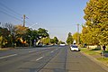 Sturt Highway through Wagga Wagga, New South Wales
 -
 The Sturt Highway through Truro, South Australia
 -
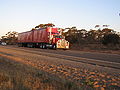 B-Double Truck on the Sturt Highway.

_Wagga.jpg)


See also[edit]
- Highways in Australia
- Highways in Victoria
- List of highways in New South Wales
- List of highways in South Australia
- Main North Road
- Gawler Bypass Road
References[edit]
- ^ "Sturt Highway". Ozroads. Retrieved 25 May 2008.
{{cite web}}: Cite has empty unknown parameter:|coauthors=(help) - ^ "Sturt Highway Upgrade". TransportSA. Department of Transport, Energy and Infrastructure. 25 August 2008. Retrieved 15 July 2008.
- ^ "Northern Expressway". TransportSA. Department of Transport, Energy and Infrastructure. 11 September 2008. Retrieved 13 September 2008.
- ^ "Sturt Highway - Riverland passing lanes". AusLink. Department of Transport and Regional Services. 20 July 2005. Retrieved 11 June 2006. [dead link]
- ^ "Sturt Highway upgrading programme". AusLink. Department of Transport and Regional Services. 15 May 2006. Retrieved 11 June 2006.
- ^ Mildura Truck Bypass - Auslink 2(PDF)
Road infrastructure in South Australia | ||
|---|---|---|
| Expressways |
| |
| Interstate highways | ||
| State highways | ||
| Arterial roads |
| |
| Outback tracks | ||
[[Category:Highways in Australia]] [[Category:Riverina]] [[Category:Highways in New South Wales]] [[Category:Highways in South Australia]] [[Category:Highways in Victoria (Australia)]]