
User:MJL/Portal:Long
< User:MJL
Portal maintenance status: (April 2019)
|
Introduction
Long may refer to: (Full article...)
Selected general articles
Did you know...
- ... that four years after Harry Frazee opened his Longacre Theatre, he sold his ownership stake in the theater to focus on baseball?
- ... that while Joseph Longworth thought that he would be remembered only as "the son of his father and the father of his son", there is today a wing of the Cincinnati Art Museum named for him?
- ... that fashion model Rebecca Leigh Longendyke was inspired by Grey's Anatomy to get a degree in biomedical engineering?
- ... that Charles Dickens described the Long Island Sound steamboat New York as "a sullen, cumbrous, ungraceful, unshiplike leviathan"?
- ... that Long Island's PBS station specialized in making shows for other stations to air during their pledge drives?
- ... that Longcat was long?
Need help?
Do you have a question about Long to which you can't find the answer?
Consider asking it at the Wikipedia reference desk.
Selected images
-

-

-
 Golden Island on the Yangtze near Zhenjiang in Jiangsu, as it was in the mid-19th century (from Yangtze)
 -
 The Three Gorges Dam in 2006 (from Yangtze)
 -
 The Imperial Japanese Navy armored cruiser Izumo in Shanghai in 1937. She sank riverboats on the Yangtze in 1941. (from Yangtze)
 -
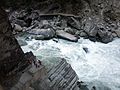
 Tiger Leaping Gorge in Yunnan (from Yangtze)
 -
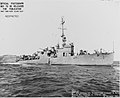 USS Long as minesweeper, Oct 1943 (from USS Long)
 -
 Wu Gorge, one of the Three Gorges (from Yangtze)
 -
 Yangtze in 1915 (from Yangtze)
 -
-
 A vehicle carrier on Yangtze (from Yangtze)
 -
 A topographical map of China depicting the Yangtze's steady course and the former route of the Yellow River south of Shandong to the Huai mouth, after its stabilization by the Grand Eunuch Li Xing's public works following the 1494 flood (from Yangtze)
 -
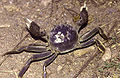 The Chinese mitten crab is a commercially important species in the Yangtze, but invasive in other parts of the world. (from Yangtze)
 -
 The "Great River" (大江) with its entrance to the East China Sea marked as the "Mouth of the Yangtze" (揚子江口) on the Jiangnan map in the 1754 Provincial Atlas of the Qing Empire (from Yangtze)
 -
 The glaciers of the Tanggula Mountains, the traditional source of the Yangtze River (from Yangtze)
 -
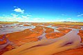 The Tuotuo River, a headwater stream of the Yangtze River, known in Tibetan as Maqu, or the "Red River" (from Yangtze)
 -
 A shipyard on the banks of the Yangtze building commercial river freight boats (from Yangtze)
 -

-
 Diagram showing dams planned for the upper reaches of the Yangtze River (from Yangtze)
 -

-
 Afternoon in the jagged mountains rising from the Yangtze River gorge (from Yangtze)
 -
 The silver carp is native to the river, but has (like other Asian carp) been spread through large parts of the world with aquaculture. (from Yangtze)
 -
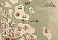
 A map of the Warring States around 350 BC, showing the former coastline of the Yangtze delta (from Yangtze)
 -
 Qutang Gorge, one of the Three Gorges (from Yangtze)
 -
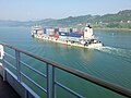 A container carrier on Yangtze (from Yangtze)
 -
 Cruise boats on Yangtze (from Yangtze)
 -
 The two sturgeon species in the Yangtze (here Chinese sturgeon) are both seriously threatened. (from Yangtze)
 -
 The critically endangered Chinese alligator is one of the smallest crocodilians, reaching a maximum length of about 2 m (7 ft). (from Yangtze)
 -
 Xiling Gorge, one of the Three Gorges (from Yangtze)
 -
 Map of the Yangtze river (facing west) showing the major settlements along its banks (from Yangtze)
 -
 The entirely aquatic Chinese giant salamander is the world's largest amphibian, reaching up to 1.8 m (5.9 ft) in length. (from Yangtze)
 -
 Barges on the river (from Yangtze)


.jpg)


_docked_in_China,_in_the_1930s.jpg)


Subcategories

- Select [►] to view subcategories
Category Long not found
Subtopics
This page may be too long to read and navigate comfortably. |
Associated Wikimedia
The following Wikimedia Foundation sister projects provide more on this subject:
-
 Commons
Free media repository -
 Wikibooks
Free textbooks and manuals -
 Wikidata
Free knowledge base -
 Wikinews
Free-content news -
 Wikiquote
Collection of quotations -
 Wikisource
Free-content library -
 Wikiversity
Free learning tools -
 Wiktionary
Dictionary and thesaurus
Purge server cache Category:Portals needing placement of incoming links