
User:Gazamp/Safekeeping
| {{{1}}} |
|2=
|2=

The Andes (/ˈændiːz/ AN-deez), Andes Mountains or Andean Mountain Range (Spanish: Cordillera de los Andes; Quechua: Anti) are the longest continental mountain range in the world, forming a continuous highland along the western edge of South America. The range is 8,900 km (5,530 mi) long and 200 to 700 km (124 to 435 mi) wide (widest between 18°S and 20°S latitude) and has an average height of about 4,000 m (13,123 ft). The Andes extend from north to south through seven South American countries: Venezuela, Colombia, Ecuador, Peru, Bolivia, Chile and Argentina.
Along their length, the Andes are split into several ranges, separated by intermediate depressions. The Andes are the location of several high plateaus—some of which host major cities such as Quito, Bogotá, Cali, Arequipa, Medellín, Bucaramanga, Sucre, Mérida, El Alto and La Paz. The Altiplano Plateau is the world's second-highest after the Tibetan Plateau. These ranges are in turn grouped into three major divisions based on climate: the Tropical Andes, the Dry Andes, and the Wet Andes. (Full article...)
Selected general articles
-


The Titicaca orestias, Lake Titicaca orestias, or Lake Titicaca flat-headed fish (Orestias cuvieri), also known by its native name amanto, is a likely extinct freshwater killifish from Lake Titicaca in South America. It belongs in the pupfish genus Orestias, endemic to lakes, rivers and streams in the Andean highlands. With a total length of up to 27 cm (10.6 in), it was the largest member in that genus. In the hope that an undiscovered population remains, it is listed as Data Deficient by the IUCN. Despite its common name, it is not the only Orestias from Lake Titicaca.
Its mouth was nearly turned upwards, thereby giving the flat head a concave shape. The head took up nearly a third of the whole body length. The upperside was greenish-yellow to umber. The lower jaw was black. Its scales were oddly light coloured at their centre. The scales of the young were blotched. (Full article...) -
Cerro Negro de Mayasquer is a volcano on the border of Colombia and Ecuador. It lies 3 kilometres (2 mi) north-west of the volcano Chiles, and the two peaks are considered part of the same Chiles-Cerro Negro volcanic complex. These volcanoes, together with Cumbal are andesitic in rock type. A 1936 eruption reported by the Colombian government agency INGEOMINAS may have been from the Ecuadorean volcano Reventador, otherwise the volcano has not erupted for around 160,000 years. (Full article...)
-
Telmatobius macrostomus, also known as the Lake Junin (giant) frog or Andes smooth frog, is a very large and endangered species of frog in the family Telmatobiidae. This completely aquatic frog is endemic to lakes and associated waters at altitudes of 4,000–4,600 m (13,100–15,100 ft) in the Andes of Junín and Pasco in central Peru. It has been introduced to slow-moving parts of the upper Mantaro River, although it is unclear if this population still persists.
Together with the closely related Amable Maria frog (T. brachydactylus), it is sometimes placed in the genus Batrachophrynus. (Full article...) -
Touching the Void is a 2003 docudrama survival film directed by Kevin Macdonald and starring Brendan Mackey, Nicholas Aaron, and Ollie Ryall. The plot concerns Joe Simpson and Simon Yates' near-fatal descent after making the first successful ascent of the West Face of Siula Grande in the Cordillera Huayhuash in the Peruvian Andes, in 1985. It is based on Simpson's 1988 book of the same name.
Critically acclaimed, Touching the Void was listed in PBS's "100 Greatest Documentaries of All Time". The Guardian described it as "the most successful documentary in British cinema history". (Full article...) -
Santa Isabel (Spanish: Nevado de Santa Isabel) is a shield volcano located in Tolima, Colombia, southwest of Nevado del Ruiz volcano. The volcano is located over the Palestina Fault, that crosscuts the underlying El Bosque Batholith of Eocene age, dated at 49.1 ± 1.7 Ma. (Full article...) -
Nevado del Ruiz (Spanish pronunciation: [neβaðo ðel ˈrwis]), also known as La Mesa de Herveo (English: Mesa of Herveo, the name of the nearby town) is a volcano on the border of the departments of Caldas and Tolima in Colombia, about 129 km (80 mi) west of the capital city Bogotá. It is a stratovolcano composed of many layers of lava alternating with hardened volcanic ash and other pyroclastic rocks. Volcanic activity at Nevado del Ruiz began about two million years ago, during the Early Pleistocene or Late Pliocene, with three major eruptive periods. The current volcanic cone formed during the present eruptive period, which began 150,000 years ago.
The volcano usually generates Vulcanian to Plinian eruptions, which produce swift-moving currents of hot gas and rock called pyroclastic flows. These eruptions often cause massive lahars (mud and debris flows), which pose a threat to human life and the environment. The impact of such an eruption is increased as the hot gas and lava melt the mountain's snowcap, adding large quantities of water to the flow. On November 13, 1985, a small eruption produced an enormous lahar that buried and destroyed the town of Armero in Tolima, causing an estimated 25,000 deaths. This event later became known as the Armero tragedy—the deadliest lahar in recorded history. Similar but less deadly incidents occurred in 1595 and 1845, consisting of a small explosive eruption followed by a large lahar. (Full article...) -

Pico Mucuñuque is a mountain in the Andes of Venezuela. It has a height of 4,609 metres. (Full article...) -
Rondoy (possibly from Quechua runtuy: "to hail" or "to lay an egg") is a 5,870-metre-high (19,259 ft) mountain in the north of the Huayhuash mountain range in the Andes of Peru. It is located in the Ancash Region, Bolognesi Province, Pacllón District, and in the Huánuco Region, Lauricocha Province, Queropalca District. Rondoy lies north of Yerupajá and Jirishanca and southwest of Lake Mitococha. (Full article...) -
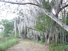
The Laguna de Sonso Nature Reserve is located in the Valle del Cauca Department of Colombia. It contains the last extensive remnant of original natural wetland remaining in the Cauca River Valley in western Colombia, and was declared a nature reserve in October 1978. It comprises a series of marshes and lagoons on the east bank of the Cauca River, between the municipalities of Buga, Yotoco and Guacari. It has an area of 2,045 ha (7.90 sq mi), lying at an altitude of 935 m (3,068 ft). The wetlands are affected by the introduced water hyacinth. The reserve has been designated as a protected Ramsar site since 2017. (Full article...) -
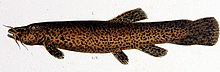
Trichomycterus rivulatus is a species of pencil catfish that is native to high-altitude Andean streams and lakes (including Junin, Poopó and Titicaca) in southern Peru, western Bolivia and northern Chile. It is the largest species in the genus Trichomycterus and grows to a maximum length of 37.4 centimetres (14.7 in) TL. The species is regularly caught as a food fish. However, because of pollution, studies have revealed levels of metals in T. rivulatus of Lake Titicaca that exceed the internationally recommended safety thresholds for human consumption. (Full article...) -
Quilotoa (Spanish pronunciation: [kiloˈto.a]) is a water-filled crater lake and the most western volcano in the Ecuadorian Andes. The 3-kilometre (2 mi)-wide caldera was formed by the collapse of this dacite volcano following a catastrophic VEI-6 eruption about 800 years ago, which produced pyroclastic flows and lahars that reached the Pacific Ocean, and spread an airborne deposit of volcanic ash throughout the northern Andes. This last eruption followed a dormancy period of 14,000 years and is known as the 1280 Plinian eruption. The fourth (of seven) eruptive phase was phreatomagmatic, indicating that a Crater lake was already present at that time. The caldera has since accumulated a 250-metre-deep (820 ft) crater lake, which has a greenish color as a result of dissolved minerals. Fumaroles are found on the lake floor and hot springs occur on the eastern flank of the volcano.
Quilotoa is a site of growing popularity. The route to the "summit" (the small town of Quilotoa) is generally traveled by hired truck or bus from the town of Zumbahua 17 kilometres (11 mi) to the South, or more commonly by bus from Latacunga. Visitors have to pay two US dollars each to enter Quilotoa. There are a number of simple hostels in the immediate area offering services such as mules and guides. Activities include a four to five-hour hike around the caldera (whose diameter is just over 3 kilometres (2 mi)). The caldera rim is highly irregular and reaches its maximum elevations 3,810 metres (12,500 ft) to the N, 3,894 metres (12,776 ft) to the NW and 3,915 metres (12,844 ft) to the SE, at three lava domes. The 10-kilometre (6 mi) hike is sandy and steep in places and can be quite taxing, particularly if there is fog. (Full article...) -
Nevado Ojos del Salado is a dormant complex volcano in the Andes on the Argentina–Chile border. It is the highest volcano on Earth and the highest peak in Chile. The upper reaches of Ojos del Salado consist of several overlapping lava domes, lava flows and volcanic craters, with sparse ice cover. The complex extends over an area of 70–160 square kilometres (27–62 sq mi) and its highest summit reaches an altitude of 6,893 metres (22,615 ft) above sea level. Numerous other volcanoes rise around Ojos del Salado.
Being close to the Arid Diagonal of South America, the mountain has extremely dry conditions, which prevent the formation of substantial glaciers and a permanent snow cover. Despite the arid climate, there is a permanent crater lake about 100 m (330 ft) in diameter at an elevation of 6,480 metres (21,260 ft)-6,500 metres (21,300 ft) within the summit crater and east of the main summit. This is the highest lake of any kind in the world. Owing to its altitude and the desiccated climate, the mountain lacks vegetation. (Full article...) -

Map showing Iru Phutunqu on the border of Bolivia and Chile, south of the Umani
Iruputuncu (possibly from Aymara iru spiny Peruvian feather grass, phutunqu a small vessel or a hole, pit, crater) is a mountain in the Andes in the Cordillera Occidental on the border of Bolivia and Chile. The Chilean side is in the Tarapacá Region, and the Bolivian side is in the Potosí Department, Daniel Campos Province, Llica Municipality. Iruputuncu is southeast of Mount Candelaria, west of the Salar de Uyuni salt flat and south of the Umani. It is about 4,200 m (13,780 ft) high. (Full article...) -
Michincha is a stratovolcano on the border of Bolivia and Chile. It is part of an east–west trending ridge of stratovolcanoes. To its east lies Olca. The only historical activity from the complex was a flank eruption from 1865 to 1867. (Full article...)
-
Pico El Toro is a mountain in the Andes of Venezuela. It has a height of 4755 metres. (Full article...)
-
Pico El León is a mountain in the Andes of Venezuela. It has a height of 4740 metres. (Full article...) -
Los Nevados National Natural Park (Spanish: Parque Nacional Natural Los Nevados) is a national park located in the Cordillera Central of the Colombian Andes. The park surrounds the northern volcanic complex formed by Nevado del Ruiz, Nevado del Tolima, Nevado de Santa Isabel, the paramillos of Cisne, Santa Rosa and Quindío and the Cerro Bravo and Cerro Machín.
The park is located in the departments of Caldas, Quindío, Risaralda, Tolima and spans between the municipalities Manizales, Villamaría, Santa Rosa de Cabal, Pereira, Salento, Villahermosa, Anzoátegui, Santa Isabel, Murillo, Ibagué and Casabianca. (Full article...) -

Tata Sabaya is a 5,430-metre (17,810 ft) high volcano in Bolivia. It is part of the Central Volcanic Zone, one of several volcanic belts in the Andes which are separated by gaps without volcanic activity. This section of the Andes was volcanically active since the Jurassic, with an episode of strong ignimbritic volcanism occurring during the Miocene. Tata Sabaya lies in a thinly populated region north of the Salar de Coipasa salt pan.
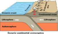
Volcanic activity at Tata Sabaya and elsewhere in the Central Volcanic Zone is the consequence of the subduction of the Nazca Plate beneath the South America Plate. The volcano has developed along a lineament that separates older crust north of the lineament from younger crust in the south, and the edifice has been formed by andesitic rocks. (Full article...) -
Simplified sketch of the present-situation along most of the Andes
The Andean orogeny (Spanish: Orogenia andina) is an ongoing process of orogeny that began in the Early Jurassic and is responsible for the rise of the Andes mountains. The orogeny is driven by a reactivation of a long-lived subduction system along the western margin of South America. On a continental scale the Cretaceous (90 Ma) and Oligocene (30 Ma) were periods of re-arrangements in the orogeny. The details of the orogeny vary depending on the segment and the geological period considered. (Full article...) -
Chacaltaya (Mollo language for "bridge of winds" or "winds meeting point", Aymara for "cold road"[dubious ]) is a mountain in the Cordillera Real, one of the mountain ranges of the Cordillera Oriental, itself a range of the Bolivian Andes. Its elevation is 5,421 meters (17,785 ft). Chacaltaya's glacier — which was as old as 18,000 years — had an area of 0.22 km2 (0.085 sq mi) in 1940, which had been reduced to 0.01 km2 (0.0039 sq mi) in 2007 and was completely gone by 2009. Half of the meltdown, as measured by volume, took place before 1980. The final meltdown after 1980, due to missing precipitation and the warm phase of El Niño, resulted in the glacier's disappearance in 2009. The glacier was located about 30 kilometers (19 mi) from La Paz, near Huayna Potosí mountain. (Full article...) -
Tupungato, one of the highest mountains in the Americas, is a massive Andean lava dome dating to Pleistocene times. It lies on the Argentina–Chile border, between the Chilean Metropolitan Region (near a major international highway about 80 km (50 mi) east of Santiago) and the Argentine province of Mendoza, about 100 km (62 mi) south of Aconcagua, the highest peak of both the Southern and Western hemispheres. Immediately to its southwest is the active Tupungatito volcano (literally, little Tupungato), which last erupted in 1987.
Tupungato Department, an important Argentine wine-producing region in Mendoza province, is named for the volcano. Recent Chilean mapping indicates it has a height of 6635m. (Full article...) -
Corazón (Spanish: "heart") is an inactive, eroded stratovolcano of Ecuador, situated about 30 km southwest of Quito in the western slopes of the Andes. (Full article...) -
The Pico Piedras Blancas (also known as Misamán), at 4,737 metres (15,541 ft), is the highest mountain of the Sierra de la Culata range in the Mérida State, and the fifth-highest mountain in Venezuela. Its name, meaning "White Stones", is of uncertain origin, since the massif is predominantly grey in color. Pico Piedras Blancas lacks glaciers; however, seasonal snowfalls may briefly cover its flanks. From its summit and under clear conditions, Lake Maracaibo can be seen. One of the accesses to reach the base of the mountain, is through the Mifafí Condor Reserve, which hosts some specimens of this andean bird. (Full article...) -

The royal cinclodes (Cinclodes aricomae) is a Critically Endangered passerine bird in the Furnariinae subfamily of the ovenbird family Furnariidae. It is found in Bolivia and Peru. (Full article...) -
Janq'u Uma (Aymara janq'u white, uma water, "white water", also spelled Ccancouma, Janjouma) is a mountain in the north of the Apolobamba mountain range in the Andes of Peru, about 4,900 metres (16,076 ft) high. It is located in the Puno Region, Sandia Province, Cuyocuyo District. Janq'u Uma lies northwest of the mountain Wilaquta, northeast of Qurwari and southwest of Utkhuqaqa. Two little streams named Janq'u Uma (Janjouma) and Qullqipirwa (Jolljepirhua) originate west and east of the mountain. They flow to the river Lawa Lawani which runs to the north. It belongs to the watershed of the Inambari River. (Full article...)


Did you know...
- ... that the 1930s Polish Andean expeditions have been credited with several first ascents and the tracing of a new route to the summit of Aconcagua, the Andes' highest peak?
Need help?
Do you have a question about Andes that you can't find the answer to?
Consider asking it at the Wikipedia reference desk.
Selected images
-
 Nevado del Huila, Colombia (from Andes)
 -
 Bolivian Andes (from Andes)
 -

-

-
 Frederic Edwin Church, Heart of the Andes, 1859. (from Andes)
 -
 A male Andean cock-of-the-rock, a species found in humid Andean forests and the national bird of Peru (from Andes)
 -
 Pico Humboldt at sunset (from Andes)
 -
 Parinacota, Bolivia/Chile (from Andes)
 -

-

-

-
 Laguna de Sonso tropical dry forest in Northern Andes (from Andes)
 -
 View of Cuernos del Paine in Torres del Paine National Park, Chile (from Andes)
 -

-

-

-
 Aerial view of Valle Carbajal in the Tierra del Fuego. The Andes range is about 200 km (124 mi) wide throughout its length, except in the Bolivian flexure where it is about 640 kilometres (398 mi) wide. (from Andes)
 -

-

-

-
 Central Andes (from Andes)
 -
 Irrigating land in the Peruvian Andes (from Andes)
 -
 Peruvian farmers sowing maize and beans (from Andes)
.jpg)


.jpg)


%E2%80%93Valle_Carbajal_01.jpg)


.jpg)


Subcategories

- Select [►] to view subcategories
Subtopics
Associated Wikimedia
The following Wikimedia Foundation sister projects provide more on this subject:
-
 Commons
Free media repository -
 Wikibooks
Free textbooks and manuals -
 Wikidata
Free knowledge base -
 Wikinews
Free-content news -
 Wikiquote
Collection of quotations -
 Wikisource
Free-content library -
 Wikiversity
Free learning tools -
 Wiktionary
Dictionary and thesaurus
-->