
User:Cavarrone/ItMassaua
.jpg)
Italian Massaua was the name used during the Italian colonization of Eritrea for the port-city of Massawa.[2]
History[edit]
On February 5, 1885 Massawa was occupied by 1500 Italian Bersaglieri under the command of colonel Tancredi.[3]
Massawa, at the beginning of the Italian civil administration, was the capital of Italian Eritrea and the only urban center of the colony. From February 1885 until 1897, Massawa served as the administrative center of the region, before Governor Ferdinando Martini moved his administration to Italian Asmara.[4] Between 1887 and 1932, the Italians expanded the Eritrean Railway, connecting Massawa with Asmara and then Bishia near the Sudan border, and completed the Asmara-Massawa Cableway.[4] At 75 km long, it was the longest ropeway conveyor in the world at the time.[5]
In 1890, Massaua had 5,000 inhabitants, of which almost 200 were Italians residents, with nearly one thousand of Italian military personnel. In the early 20th century, an architectural plan similar to the one in Asmara was adopted for city. It included a commercial and industrial area.[6]
The plan to improve the city that was prepared was aimed at reordering distinct parts that made up the town and that bordered the inlet of the port, the islands of Massawa and Taulud, connected to each other and the mainland by dams, the peninsulas of Gerar and Abd-el-Kader and the hinterland Edaga Berai near the dam Taulud. The "master" plan was prepared by the Italian Central Office of Civil Engineers in 1914, but was approved only for the part about the island of Taulud. The zoning required by the building code of 1915 fixed a structure which was confirmed by subsequent plans of the twenties and thirties.
The island of Massawa, where the ancient Ottoman-Arab core, unlike other urban colonial areas, had a mixed use for a variety of reasons, including a major that was linked to the use of the port, being the platform that limited its northern flank of the island the only one for the docking of large ships. So, in this area were concentrated all commercial activities. The island of Taulud, on whose northern end stood the palace of the "Khedive" Turkish, was reused first as the headquarters of the Italian military command, and then as the Government Palace: later became the area where was focused the Italian-Eritreans-metropolitan population. The area reserved to the natives was across the plain of Edgarà Berai, where arose the new suburbs after the Italian occupation. The peninsula of Gerar was given to the industrial area, while that of Abd-el-Kader remained occupied by military installations.
The works for the relocation of the port was started in 1913 on the basis of a draft by architect Luigi Luiggi and the Central Office of Civil Engineers of Massawa. In 1921 the city was badly damaged by an earthquake, but the reconstruction was done quickly through the grant of loans and government subsidies to individuals and businesses. In the same year were approved with a new plan where the building were programmed with earthquake standards.
From 1928, with fascism rule were carried out in the port further expansion works, even in relation to the newly created railway and cableway to the capital Asmara. During the 1935/1936 war with Ethiopia in Massawa was recorded a significant increase in traffic, since it had become the main base for the supplies of the military campaign; and in subsequent years, with the new role of "Port of the Italian Empire", the city saw a great development with the increase of the population.
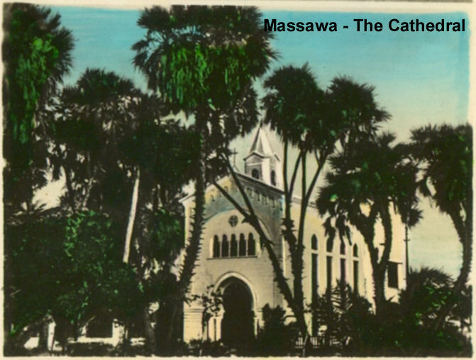
Italian Massaua in 1938 touched 15,000 inhabitants. Italians favored the development of Catholicism in the city, and a new catholic cathedral was built in the late 1930s.[7] The urban plans for the various areas of the city were implemented: in the island of Massawa was traced a road ring, while in that of Taulud was to be built a residential neighborhood. A settlement with industrial plants was expected in the peninsula of Gerar, with new areas to the decentralized Archico-Gurgussum. In addition it was decided the reorganization of the nearby villages of Edaga Berai and Amatereh with the small nucleus Otumlo located inside.
In the port area was planned the construction of a huge "Stazione marittima" (Sea Station) for ocean liners, but the beginning of WWII blocked all this further improvements of Italian Massaua.
The Port of Italian Massaua[edit]
At the end of the 19th century, the Kingdom of Italy created a modern port in Massaua for their newly acquired colony of Eritrea.[8]

The Italian colony suffered repeated earthquakes. Most of the city was completely destroyed by the 1921 Earthquake: it took until 1928 to fully restore the port,[9] hampering initially the Italian colonial ambitions.
The Italian colonialists had nevertheless built Italian Massaua to become the largest and safest port on the east coast of Africa, and the largest deep-water port on the Red Sea. Between 1887 and 1932, they expanded the Eritrean Railway, connecting the port of Massawa with the Eritrean capital Asmara, and completed the 75 kms long Asmara-Massawa Cableway.[10] As a consequence the commercial activity of the port grew to nearly one million tons of merchandise, with more than 180000 passengers in 1939.[11]
In early 1941, Italian Massaua had nearly 20,000 inhabitants, of which almost 3,500 were Italians.
After the creation of the Africa Orientale Italiana the Italian government increased the international ship lines serving the port of Massaua: while in the late 1920s were needed 16 days from Massaua to Genova or Venice in Italy, after 1939 were needed only 5 days.
List of main ship routes from Italian Massaua in early 1940, just before the start of war against the Allies:[12]

- Italia-Massaua-China/Japan (Italian Line), biweekly
- Genova-Massaua-Mogadiscio-Chisimaio (Lloyd Triestino), weekly
- Italia-Massaua-Australia (Lloyd Triestino), weekly
- Napoli-Massaua-Assab-Gibuti (LLoyd Triestino), weekly
- Italia-Massaua-Assab-South Africa (Lloyd Triestino), monthly
- Venezia-Massaua-India (Veneta di navigazione), weekly
- Genova-Massaua-Mogadiscio (RAMB), weekly
- Venezia-Massaua-Mogadiscio (RAMB), biweekly
- Genova-Massaua-Assab (I. Messina), biweekly
The service was done with modern Ocean liners like the Conte Biancamano, "Victoria", "Esquilino" and "Viminale".
In those years there was even a local service (called "linea Circolare del Mar Rosso") that connected all the main ports in the Red Sea. Another (called "linea Intercoloniale") connected Massaua with Assab-Gibuti and the main ports of British Somaliland and Italian Somaliland.
The port of Massaua was going to be enlarged in 1941, but WWII blocked it.
Italy was one of the Axis powers during World War II and Massawa was the homeport for the Red Sea Flotilla of the Italian Royal Navy. On April 8, 1941 one motor-torpedo boat of the Flotilla, the MAS 213, made a successful torpedo attack on the british cruiser HMS Capetown partially sinking it just out of the Massaua port.[13] When the city fell during the East African Campaign, a large number of Italian and German ships were sunk in an attempt to block use of Massawa's harbor.[14]
From 15 April 1942, later master diver and salvage specialist RNR Lieutenant Peter Keeble (then a complete rookie in both disciplines) was assigned to the clearing of the harbour.[15] He succeeded only in the simple task of salvaging an ex-Italian tugboat. The same month, United States Navy Commander Edward Ellsberg and his handful of crew arrived to take over. The wrecks were salvaged in short order and the port was returned to service, as part of what had now become the British protectorate of Eritrea.
In 1945, following the end of World War II, the port of Massawa suffered damage as the occupying British either dismantled or destroyed much of the facilities. These actions were protested by Sylvia Pankhurst in her book Eritrea on the Eve.[16]

Notes[edit]
- ^ Banco d'Italia in Massaua being rebuilt
- ^ Map of Italian Massaua (1929)
- ^ "Occupazione di Massaua" (in Italian)
- ^ a b Belula Tecle-Misghina. Asmara - an urban history. Edizioni Nuova Cultura, 2015. ISBN 8868123541.
- ^ Giovanni Gentile, Calogero Tumminelli. Enciclopedia italiana di scienze, lettere ed arti, Volume 1. Istituto Giovanni Treccani, 1929. p. 66.
- ^ Italian Massaua Plan (in Italian). p. 65
- ^ Massaua Cathedral
- ^ Images of Italian Massaua before WWI
- ^ Killion, Tom (1998). Historical Dictionary of Eritrea. The Scarecrow Press. ISBN 0-8108-3437-5.
- ^ "La Teleferica Massaua-Asmara" cableway brochure, translated by Mike Metras, Dave Engstrom, and Renato Guadino
- ^ GuglielmoEvangelista. "Porti dell'Eritrea" ([1])
- ^ "Porti dell'Eritrea", by Guglielmo Evangelista
- ^ MAS 213 attack on British cruiser (in Italian)
- ^ Photo of sunken ships in Massaua port
- ^ Keeble, Peter (1957). Ordeal by water. Longmans, Green & co. No ISBN number available.
- ^ Also detailed in the chapter "The Feminist Fuzzy-Wuzzy" of Michela Wong's I didn't do it for you: how the world betrayed a small African nation (New York: Harper-Perennial, 2005), pp. 116-150.
Bibliography[edit]
- Mantegazza, Vico. Da Massaua a Saati: narrazione della spedizione italiana del 1888 in Abissinia. Editore F. Treves, 1888. (University of Chicago, 2014 [2])
- Maravigna, Pietro. Come abbiamo perduto la guerra in Africa. Le nostre prime colonie in Africa. Il conflitto mondiale e le operazioni in Africa Orientale e in Libia. Testimonianze e ricordi. Tipografia L'Airone. Roma, 1949.
- Negash, Tekeste. Italian colonialism in Eritrea 1882-1941 (Politics, Praxis and Impact). Uppsala University. Uppsala, 1987.
See also[edit]


Category:Italian colonisation in Africa Category:History of Eritrea