User:Arunreginald/Sandbox 1

The 1935 Balochistan Earthquake (Urdu: بلوچستان زلزلہ) occurred on May 30, 1935 at Quetta, Balochistan, Pakistan, then part of British India. The earthquake had a magnitude of 7.7 Mw[1] and anywhere between 30,000 and 60,000 people died from the impact. This ranks as one of the deadliest earthquakes that hit South Asia.[1]The quake was centred 4.0 kilometres South West of Ali Jaan, Balochistan, British India.[1]
The earthquake[edit]
Quetta and its neighbouring towns lay in the most active seismic region of Pakistan atop the Chamman and Chiltan fault lines. A disturbance in the geological activity resulted in an earthquake early in the morning on 31 May 1935 estimated anywhere between the hours of 2:30 am[1] and 3:40 am[2] which lasted for three minutes with continuous aftershocks. Although there were no instruments good enough to precisely measure the magnitude of the earthquake, modern estimates cite the magnitude as being a minimum of 7.7 Mw on the Richter magnitude scale and previous estimates of 8.1 Mw are now regarded as an overestimate. The epicentre of the quake was established to be 4-kilometres south-west of the town of Ali Jaan in Balochistan, some 153-kilometres away from Quetta in British India. The earthquake caused destruction in almost all the towns close to Quetta including the city itself and tremors were felt as far as Agra, now in India. The largest aftershock was later measured at 5.8 Mw occurring on 2 June 1935.[1] This however did not cause any damage in Quetta but the towns of Mastung, Maguchar and Kalat were seriously affected by this aftershock.[1]
Casualties[edit]

Most of the reported casualties occurred in the city of Quetta. Initial communique drafts issued by the Government estimated a total of 20,000 people buried under the rubble, 10,000 survivors and 4,000 injured. The city was badly damaged and was immediately prepared to be sealed under the military guard with medical advice.[2] All the villages between Quetta and Kalat were destroyed and the British feared casualty to be of higher numbers in surrounding towns; it was later estimated to be no where close to the damage caused in Quetta.
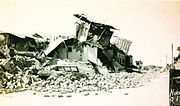
Infrastructure was severely damaged. The railway area was completely destroyed and all the houses were razed to the ground with the exception of the Government House that stood in ruins. A quarter of the Cantonment area was destroyed but military equipment and the Royal Air Force garrison suffered serious damages. It was reported that only 6 out of the 27 machines worked after the initial seismic activity.[2] A Regimental Journal for the 1st Battalion of the Queen's Royal Regiment based in Quetta issued on November 1935 stated,
It is not possible to describe the state of the city when the battalion first saw it. It was completely razed to the ground. Corpses were lying everywhere in the hot sun and every available vehicle in Quetta was being used for the transportation of injured … Companies were given areas in which to clear the dead and injured. Battalion Headquarters were established at the Residency. Hardly had we commenced our work than we were called upon to supply a party of fifty men, which were later increased to a hundred, to dig graves in the cemetery.[2]
Rescue efforts[edit]
Tremendous losses were incurred on the city in the days following the event. On streets lay dead, buried beneath the debris some still alive. British regiments were scattered around town to rescue people, an impossible task as 1st Queen's remember.[2] The weather did not prove to be of much help and the scorching summer heat made matters worse.
Bodies of European and Anglo-Indians were recovered and buried into a British cemetery where soldiers had dug trenches. Padres performed the burial service in haste as soldiers would cover the graves quickly.[2] Others were removed in the same way and taken to a nearby shamshāngāht for their remains to be cremated.
While the soldiers excavated through the debris for a sign of life, the Government issued the Quetta administration with instructions to build a tent city to house the homeless survivors and to provide shelter to their rescuers.[citation needed] A fresh supply of medicated pads was brought forth for the soldiers to wear over their mouths while they dug for bodies in fears of a spread of disease from the dead bodies buried underneath.[2]
|
Significance[edit]
The natural disaster ranks as the 23rd most deadliest earthquake worldwide to date. In the aftermath of the 2005 Kashmir earthquake, the Director General for the Meteorological Department at Islamabad, Chaudhry Qamaruzaman cited the earthquake as being amongst the four deadliest earthquakes the South Asian region has seen; the others being the Kashmir earthquake in 2005, Pasni earthquake in 1945 and Kangra earthquake in 1905.
References[edit]
See also[edit]
External links[edit]
- 1935 Quette Earthquake Dawn
- 1935 Quette Earthquake photos
- The Quetta Earthquake 1935
- Queen's Royal Surrey Accounts
- The Great Quetta
Balochistan 1935 Balochistan 1935 Category:History of Balochistan Balochistan earthquake


