
Upper Elochoman, Washington
This article needs additional citations for verification. (October 2013) |
Upper Elochoman, Washington | |
|---|---|
 Upper Elochoman, Washington | |
| Coordinates: 46°14′25″N 123°19′28″W / 46.24028°N 123.32444°W | |
| Country | United States |
| State | Washington |
| County | Wahkiakum |
| Elevation | 102 ft (31 m) |
| Population (2010) | |
| • Total | 193 |
| Time zone | UTC-8 (Pacific (PST)) |
| • Summer (DST) | UTC-7 (PDT) |
| ZIP code | 98612[1] |
| Area code | 360 |
Upper Elochoman is a census-designated place (CDP) in Wahkiakum County, Washington, United States. The population was 193 at the 2010 census.[2] The CDP includes the State Camp community.
References[edit]
- ^ "Upper Elochoman WA ZIP Code". zipdatamaps.com. 2023. Retrieved June 16, 2023.
- ^ "U.S. Census website". United States Census Bureau. Retrieved May 14, 2011.
Municipalities and communities of Wahkiakum County, Washington, United States | ||
|---|---|---|
| Town | 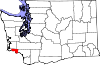 | |
| CDPs | ||
| Other communities | ||