
Tinnie, New Mexico
Tinnie, New Mexico | |
|---|---|
 Tinnie  Tinnie | |
| Coordinates: 33°22′14″N 105°13′35″W / 33.37056°N 105.22639°W | |
| Country | United States |
| State | New Mexico |
| County | Lincoln |
| Elevation | 5,171 ft (1,576 m) |
| Time zone | UTC-7 (Mountain (MST)) |
| • Summer (DST) | UTC-6 (MDT) |
| ZIP codes | 88351[1] |
| Area code | 575 |
| GNIS feature ID | 923707[2] |
Tinnie is an unincorporated community located in Lincoln County, New Mexico, United States. The community is located on U.S. Route 70, 22 miles (35 km) east of Ruidoso Downs. Tinnie has a post office with ZIP code 88351.[1][3]
References[edit]
- ^ a b United States Postal Service. "USPS - Look Up a ZIP Code". Retrieved November 30, 2014.
- ^ "Tinnie". Geographic Names Information System. United States Geological Survey, United States Department of the Interior.
- ^ "Postmaster Finder - Post Offices by ZIP Code". United States Postal Service. Retrieved November 30, 2014.
Municipalities and communities of Lincoln County, New Mexico, United States | ||
|---|---|---|
| City | 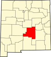 | |
| Town | ||
| Villages | ||
| CDP | ||
| Other unincorporated communities | ||
| Ghost towns | ||
This New Mexico state location article is a stub. You can help Wikipedia by expanding it. |