
Tates Bluff, Arkansas
Tates Bluff, Arkansas | |
|---|---|
 Tates Bluff, Arkansas  Tates Bluff, Arkansas | |
| Coordinates: 33°47′56″N 92°54′04″W / 33.79889°N 92.90111°W | |
| Country | United States |
| State | Arkansas |
| County | Ouachita |
| Elevation | 200 ft (60 m) |
| Time zone | UTC-6 (Central (CST)) |
| • Summer (DST) | UTC-5 (CDT) |
| Area code | 870 |
| GNIS feature ID | 57203[1] |
Tates Bluff is an unincorporated community in Ouachita County, Arkansas, United States. Tates Bluff is located near the northern border of Ouachita County, 15.2 miles (24.5 km) north-northwest of Camden.[2] The Tate's Bluff Fortification, which is listed on the National Register of Historic Places, is located near Tates Bluff.[3]
References[edit]
- ^ "Tates Bluff". Geographic Names Information System. United States Geological Survey, United States Department of the Interior.
- ^ Ouachita County, Arkansas General Highway Map (PDF) (Map). Arkansas State Highway and Transportation Department. 2008. Retrieved December 1, 2012.
- ^ "National Register Information System". National Register of Historic Places. National Park Service. July 9, 2010.
Municipalities and communities of Ouachita County, Arkansas, United States | ||
|---|---|---|
| Cities | 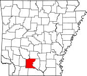 | |
| Town | ||
| CDP | ||
| Other unincorporated communities | ||
| Footnotes | ‡This populated place also has portions in an adjacent county or counties | |
This article about a location in Ouachita County, Arkansas is a stub. You can help Wikipedia by expanding it. |