Talk:Pontypridd, Caerphilly and Newport Railway
| This article is rated C-class on Wikipedia's content assessment scale. It is of interest to the following WikiProjects: | |||||||||||||||||||||||||||||||||
| |||||||||||||||||||||||||||||||||
Heading text[edit]
| The route diagram template for this article can be found in Template:Pontypridd, Caerphilly and Newport Railway RDT. |
The position of the halt serving the village of Rhydyfelin appears to have moved between a 1920s OS map and and 1930s OS map to which I have access (Historic Roam). Was the more northerly of these called Treforest Halt? It seems unlikely. Certainly the two halts do not appear to have both been open at the same time. What is the evidence for the existence of Halt called 'Treforest' on this line, as it runs on the opposite side of the valley from Treforest? - and Rhydyfelin (High Level) would be little more than a mile from Glyntaff Halt.Ntmr (talk) 13:15, 18 July 2014 (UTC) Further, the OS map shows no halt between Rhydyfelin Halt (at the top of Dyffryn Road) and Dynea Halt: they are only just over 600m apart. — Preceding unsigned comment added by Ntmr (talk • contribs) 13:18, 18 July 2014 (UTC) I now realise that the discrepancy between the location of Rhydyfelin (High Level) Halt in the OS plans from the 1920s and 1930s is explained by the note on the page relating to it which says it was resited in 1928.Ntmr (talk) 16:05, 21 July 2014 (UTC)
I have looked in to this further. A reprint that I have of Bradshaws, July 1938 Guide clearly shows the first halt to the south of Pontypridd as 'Treforest Halt', followed then by Rhydyfelin (High Level), Dynea, Upper Boat, Groeswen, Nantgarw (High Level), and then Caerphilly. However, local people I believe referred to it as Glyntaff Halt and it is referred to as such in at least one book of historic local photographs. It is POSSIBLE that the halt was renamed after nationalisation - though the halt didn't survive long into the BR period - as there was already a Treforest station (and there had been another on the Barry line), though this is perhaps unlikely as the scope for confusion would already have existed after the Big Four companies were set up. Prior to that the Pontypridd, Caerphilly and Newport Company would have presumably wanted to imply that they had a station in the rather better-known settlement of Treforest, rather than the smaller Glyntaff. Would it be acceptable to rename the relevant halt 'Treforest Halt (Glyntaff)' pending a more definite resolution of this? This would of course mean that the appearance of 'Treforest' to the south of Rhydyfelin would then be deleted.Ntmr (talk) 15:58, 21 July 2014 (UTC)
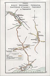
The mystery thickens: the Railway Clearing House diagram of 1912

shows a halt or station on the P,C & N Line called 'Glyntaff'. — Preceding unsigned comment added by Ntmr (talk • contribs) 13:22, 24 July 2014 (UTC)
I have amended the new Route Diagram: the discussion here does, I think, establish that (a) there was only ever one halt between Pontypridd (Tram Road) and Rhydyfelin (High Level) and (b) it was called at different times 'Glyntaff' and 'Treforest' but it has not so far been possible to establish if and when the name was formally changed. Please take account of this discussion before making any further amendments.Ntmr (talk) 21:58, 9 April 2015 (UTC)
- I don't think that's right. The sequence of Halts leaving Pontypridd was
- * Tram Road Halt
- * Glyntaff Halt
- * Treforest
- Glyntaff and Treforest both appear in the 1922 Bradshaw (reprint widely available). Glyntaff opened on 1 September 1904 and closed on 5 May 1930. Treforest opened on 1 September 1904 and closed on 17 September 1956. (Butt gives the opening dates as "April 1904" but I find Quick more reliable.) Cobb agrees the years but doesn't give months.
- Going through the sequence of OS Maps at the period, they are both there at the same time on the relevant maps; for example 1919 1:2,500, you get [Tram Road] "Halt" immediately south of the Taff; [Glyntaff] "Station" immediately east of Pentre-Bach Road; and [Treforest] "Halt" immediately south of Glyntaff Road. Afterbrunel (talk) 11:27, 5 June 2017 (UTC)


