
Talk:National Register of Historic Places listings in Portage County, Ohio
| This article is rated List-class on Wikipedia's content assessment scale. It is of interest to the following WikiProjects: | ||||||||||||||||||||||||
| ||||||||||||||||||||||||


Ohio State Normal College At Kent[edit]
I've unpiped the link for the Ohio State Normal College At Kent because the listing isn't the same as KSU: it appears to be only a part of the campus, so it could altogether reasonably have its own article. Nyttend (talk) 01:01, 26 May 2009 (UTC)
- I'm not sure it's a separate institution. Ohio History Central seems to indicate that it's the extent Kent State University. (Assuming, of course, that Kent State Normal College and Ohio State Normal College at Kent are one and the same.) However, the map location might point to Kent State University School, which although it was part of KSU, it also served as a kind of "charter school" for area secondary students. (The idea was that KSU would use the school as a laboratory for education majors at the university.) Is this the present Franklin Hall? If so, it was indeed the university school. -- JeffBillman (talk) 01:30, 26 May 2009 (UTC)
- From what I understood it's talking about the oldest part of campus, known locally as "Front Campus," along Hilltop Drive. All the buildings there were built between 1914 and 1926. The University School was only in Franklin Hall from 1926 until the 1950's so I don't think it has that much historical significance apart from the other buildings. Up until I saw the NRHP, I had never seen or heard of the school ever being referred to as the "Ohio State Normal College at Kent" in any of my readings. I'd like to see where and when that name was used (and for how long)! I have no problem with it being a separate article. --JonRidinger (talk) 01:47, 26 May 2009 (UTC)
- Here is the infobox for it: I have made the usual NRHP project corrections: un-capitalize At, switch name from last, first to first last order.
Ohio State Normal College at Kent | |
 | |
| Location | Hilltop Dr. on Kent State University campus, Kent, Ohio |
|---|---|
| Coordinates | 41°9′6″N 81°20′53″W / 41.15167°N 81.34806°W |
| Built | 1923 |
| Architect | George Francis Hammond; Robert H.Evans & Co. |
| Architectural style | Classical Revival |
| NRHP reference No. | 75001526 "National Register Information System". National Register of Historic Places. National Park Service. 2009-03-13. |
| Added to NRHP | May 30, 1975 |
From this it would appear that what was added to the NRHP is a Classical Revival building on Hilltop Drive on the KSU campus which was built in 1923 by Robert H.Evans & Co. and designed by George Francis Hammond. According to Cleveland Encyclopedia of History, Hammond was "an important classical architect active in Cleveland from 1886-1926." clariosophic (talk) 03:11, 26 May 2009 (UTC)
Some more references:
- Map of North Campus
- Front Campus
- Merrill Hall built in 1912, original building. clariosophic (talk) 03:30, 26 May 2009 (UTC)
- What I was trying to say, by the way, is not that this was a different school — I meant that the listing surely didn't include the entire school. "Listing" in this context, as I use it, means "the building or buildings that is/are listed on the Register". Thanks for the fast work! Nyttend (talk) 04:11, 26 May 2009 (UTC)
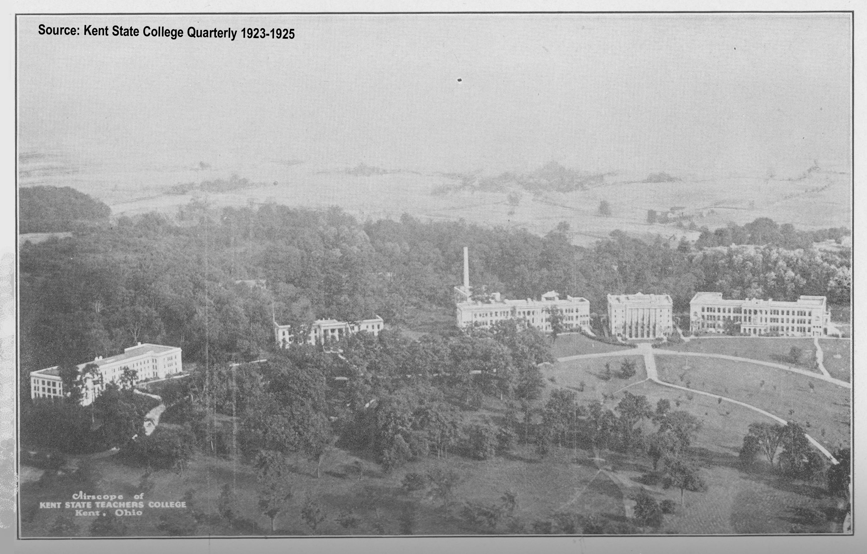
- Thanks for your work. I'm still thinking it's referring to the entire Front Campus, all of which are Classical Revival. Not sure where the 1923 date comes from as no building there opened that year. The closest one is Franklin Hall in 1926 and I'm pretty certain it was designed by a completely different firm than the rest of the original campus. The school was "founded" in 1910 but didn't hold classes until 1912. The first classes in Kent were held in May 1913 at the new Merrill Hall. George Francis Hammond likely designed the first 5 buildings on the campus: Merrill Hall (1912), Lowry Hall (1913), Cartwright Hall (formerly the Administration Building and Auditorium Building) (1914), Kent Hall (1915), and Moulton Hall (1917) (see KSU Architecture Library). This photo shows the original 5 buildings that are still there as they appeared in 1923. Other historical photos and maps can be found here. --JonRidinger (talk) 04:26, 26 May 2009 (UTC)
- Thanks for the aerial photo. The title says 1923-25, which may explain the 1923 date on the infobox. Does anyone have access to the NRHP nomination form? That's the only thing that would give us a definitive answer. I suspect from Googling that the NRHP name did not leave much trace and that some variant of Kent State was used almost from the beginning clariosophic (talk) 20:17, 26 May 2009 (UTC)
- Yes I would agree. Perhaps the "Ohio State Normal College at Kent" was a working name or the first legal name before it was formally named (though it is used in the Cleveland Encyclopedia of History entry you referenced previously). The only variant I have ever seen besides "Kent State Normal School" is just "Kent Normal School" and then of course later (1915) Kent State Normal College. I found where the NRHP forms should be but they have not been digitized, so I'd have to send a request for them. I took several pictures of the area today and plan on posting them soon to my Commons page. I took some general pictures and some of each of the main buildings along Hilltop Drive. --JonRidinger (talk) 21:33, 26 May 2009 (UTC)
- Most Ohio nomination forms (as you may already know) are not online; if you go to http://nrhp.focus.nps.gov/natreghome.do?searchtype=natreghome and put in the requisite data, you'll get to a page saying that it's not yet been digitised. You can request a hard copy of the form, emailing to nr_reference@nps.gov, and they'll send it to you for free. Nyttend (talk) 21:34, 26 May 2009 (UTC)
- Thanks! I was planning on doing that so you read my mind! :) --JonRidinger (talk) 21:42, 26 May 2009 (UTC)
Riddle Block No. 5[edit]
I was taking pictures of the various Riddle Blocks and the Phoenix Block in downtown Ravenna and noticed that the addresses listes for Riddle Block No. 5 were incorrect. There is an old building at the addresses (141-145 E. Main Street) but it is adjacent to the Riddle Block No. 5 building. The nice thing about the Riddle buildings is that each one has a visible marker identifying them as "Riddle Block No. X", so it's pretty easy to tell which one is which. The building with the faint "Riddle Block No. 5" on it had the addresses of 102, 104, and 106 and faced North Prospect Street and was behind the building listed for the address of the Riddle Block 5. If you look at the photo File:Riddle Block No 5.jpg and open it in full resolution, you should be able to faintly see "Riddle Block" inside the center arch. "No. 5" is below those words, but it was very faint even in person. File:Riddle Block No 5 view.jpg shows the relation of the building as seen from East Main Street looking up North Prospect Street with the actual No. 5 on the left side of the picture and the building whose addresses are listed featured in the center. --JonRidinger (talk) 05:09, 18 September 2009 (UTC)
- See this page, the Ohio Historical Society NRHP database entry for the Riddle Block #5: the photo is clearly of the building along Main Street. Did you happen to see a number for the Main building? Do you remember if it had a Riddle marker like the others? I'm not sure what to make of this situation, but it seems to me that the wrong name has been given for the NRHP-listed property. Perhaps we should contact people at the OHS? Nyttend (talk) 21:56, 21 September 2009 (UTC)
- I pass the Main St. building every day, as it's just a few blocks from where I live. I don't remember a Riddle marker on it, and it's in a different style than the Riddle buildings. A faded painted sign at the top of the building identifies it as _______ House; unfortunately, I can't make out the first word. This link from Google Maps gets us close to the building, where there is a street view: http://maps.google.com/maps?f=q&source=s_q&hl=en&geocode=&q=Ravenna,+OH&sll=37.0625,-95.677068&sspn=34.534108,79.013672&ie=UTF8&ll=41.157587,-81.240512&spn=0.002003,0.004823&t=h&z=18&layer=c&cbll=41.157613,-81.24127&panoid=IrIQn1PLIn45EltbUvMI-g&cbp=12,0.63,,0,-15.82 I think you're right: Either the wrong name has been given for the listed property, or the listed property has the wrong address. What's more troubling, either building could conceivably have been listed with the NRHP, in my opinion. -- JeffBillman (talk) 22:32, 21 September 2009 (UTC)
- We should get some information from this document, the Multiple Property Submission form for the Ravenna Commercial Center MRA, which includes the Riddle Blocks. The page won't display at the moment, but this is typical for the National Park Service website; it shouldn't be too long before it's running again. Nyttend (talk) 23:14, 21 September 2009 (UTC)
- I pass the Main St. building every day, as it's just a few blocks from where I live. I don't remember a Riddle marker on it, and it's in a different style than the Riddle buildings. A faded painted sign at the top of the building identifies it as _______ House; unfortunately, I can't make out the first word. This link from Google Maps gets us close to the building, where there is a street view: http://maps.google.com/maps?f=q&source=s_q&hl=en&geocode=&q=Ravenna,+OH&sll=37.0625,-95.677068&sspn=34.534108,79.013672&ie=UTF8&ll=41.157587,-81.240512&spn=0.002003,0.004823&t=h&z=18&layer=c&cbll=41.157613,-81.24127&panoid=IrIQn1PLIn45EltbUvMI-g&cbp=12,0.63,,0,-15.82 I think you're right: Either the wrong name has been given for the listed property, or the listed property has the wrong address. What's more troubling, either building could conceivably have been listed with the NRHP, in my opinion. -- JeffBillman (talk) 22:32, 21 September 2009 (UTC)
- The building along Prospect Street has a Riddle Marker on it. It's smaller and faint, but says "Riddle Block No. 5". In my file File:Riddle Block No 5.jpg as I mentioned above, when viewed in full resolution has the Riddle Block marker on it in the center arch. I agree with Jeff that the building listed that faces E. Main (File:Riddle Block No 5 view.jpg) is worthy to be included, but it isn't the original Riddle Block No. 5, nor is it marked. If anything it is an addition of some sort or a separate unmarked Riddle building or it's just another older building. If you want I can go back and get a closer view of the marker. --JonRidinger (talk) 23:22, 21 September 2009 (UTC)
- That was fast; after I began typing the above document, the link started working again. Page 7 of the nomination form gives the answer — both photos are actually of the same building. The building on Main Street is the original, while the Prospect Street building is a later addition that's actually part of the Main Street building. This explains the lack of a Riddle marker on the front building, the Main Street address despite the header over Prospect Street, the style of the rear being more like the other Riddle Blocks than the front is, and the photo at the OHS website. With all of this information available, I'm going to undo the address change and switch the photo to File:Riddle Block No 5 view.jpg. Nyttend (talk) 23:23, 21 September 2009 (UTC)
- Works for me. Thanks for your efforts Nyttend! This also answered a question I had about the Phoenix Block. It's actually not the building right on the corner of Chestnut and Main, but apparently the building adjacent to it. Doesn't affect the picture though thank goodness! --JonRidinger (talk) 23:27, 21 September 2009 (UTC)
- Shouldn't we also list the three address on Prospect Street (102-106 N. Prospect St.) since the form shows the entire building as part of Riddle Block 5? --JonRidinger (talk) 23:39, 21 September 2009 (UTC)
- I disagree: first off, the NRIS lists the building at Main, and it's a valid address, so I don't think that we need to change the NRIS data in any way, even by adding to it. Moreover, the old part of the building is on Main, so I think that should be given priority. It's officially one building anyway, so I think that it's best to give the address of the front of the building. Nyttend (talk) 01:01, 22 September 2009 (UTC)
- I personally think it would make things a little clearer, especially since the building at 102-106 N. Prospect is the one with the visible "Riddle Block No. 5" marker on it and the two buildings do not appear to be one in the same. They may officially be one building, but in a downtown setting having buildings touching like that is quite common as you know and does not mean they are connected in any way besides sharing a common wall. The simple fact that I came up with the conclusion I did based on visible evidence shows that having both sets of addresses listed ("141-145 E. Main & 102-106 N. Prospect") would be clearer to anyone who actually would take an interest in these buildings. If the marker wasn't on the addition, I would probably say leave it alone, but in this case I don't think extra clarification would hurt. The same thing can be said for the Phoenix Block. The NRIS says it is at the "northeast corner of Chestnut & Main" when in reality, it is adjacent to (but not including) the building at the northeast corner of Chestnut and Main according to the NRHP nomination document. --JonRidinger (talk) 02:08, 22 September 2009 (UTC)
- They aren't visible in the picture (wrong angle...wasn't really going for them) I got of what we now know is the addition, but I can get another one if you think that would be beneficial. I got the address numbers from seeing the building when I was taking the pictures. --JonRidinger (talk) 02:20, 22 September 2009 (UTC)
- That was fast; after I began typing the above document, the link started working again. Page 7 of the nomination form gives the answer — both photos are actually of the same building. The building on Main Street is the original, while the Prospect Street building is a later addition that's actually part of the Main Street building. This explains the lack of a Riddle marker on the front building, the Main Street address despite the header over Prospect Street, the style of the rear being more like the other Riddle Blocks than the front is, and the photo at the OHS website. With all of this information available, I'm going to undo the address change and switch the photo to File:Riddle Block No 5 view.jpg. Nyttend (talk) 23:23, 21 September 2009 (UTC)
- The building along Prospect Street has a Riddle Marker on it. It's smaller and faint, but says "Riddle Block No. 5". In my file File:Riddle Block No 5.jpg as I mentioned above, when viewed in full resolution has the Riddle Block marker on it in the center arch. I agree with Jeff that the building listed that faces E. Main (File:Riddle Block No 5 view.jpg) is worthy to be included, but it isn't the original Riddle Block No. 5, nor is it marked. If anything it is an addition of some sort or a separate unmarked Riddle building or it's just another older building. If you want I can go back and get a closer view of the marker. --JonRidinger (talk) 23:22, 21 September 2009 (UTC)
- List-Class United States articles
- Mid-importance United States articles
- List-Class United States articles of Mid-importance
- List-Class Ohio articles
- Mid-importance Ohio articles
- WikiProject Ohio articles
- WikiProject United States articles
- List-Class National Register of Historic Places articles
- Mid-importance National Register of Historic Places articles
- List-Class National Register of Historic Places articles of Mid-importance