
Talk:Khirbat al-Minya
A fact from Khirbat al-Minya appeared on Wikipedia's Main Page in the Did you know column on 25 July 2009 (check views). The text of the entry was as follows:
|
| This article is rated Start-class on Wikipedia's content assessment scale. It is of interest to the following WikiProjects: | |||||||||||||||||||||||||||||||
| |||||||||||||||||||||||||||||||


Old pictures[edit]
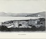
The al-Minya ruins have been known for a long time; they were noted by western explorers in the 19th century...who thought it was ancient Capernaum. (look at this link from the Capernaum-site:
- "The identification of the ruins of Talhum with ancient Capharnaum was not accepted unanimously by the topographers of the nineteenth century; in fact, several scholars identified Capharnaum with Kh. Minyeh, a ruin in the Ginnosar valley due S of Tell 'Oreimeh and 14 km from Tiberias.
- Today, after the excavations of both Talhum and Kh. Minyeh, and after a better knowledge of literary sources, the identification of ancient Capharnaum with Talhum is no longer a matter of dispute. To start with, the ruins of Kh. Minyeh turned out to be simply an Omayyad castle, and no pre-Arab remains were found." (my "bolding"!!))
The Capernicum-ruins were located further north. But there were pictures taken in that period...which I wonder was from al-Minya? Take a look at
-
 Tabgha
 -
 "Caparnicum"


...are the above pictures of the al-Minya ruins?
....also; perhaps we should say something about the khan, which was constructed 200-300 meters away from the site ..about 600 years later. Cheers, Huldra (talk) 21:38, 16 July 2009 (UTC)
- I've also come across in Fifty Cities of the Bible that Edward Robinson thought Kh. Minya was Capernaum, but the excavations revealed no remains of anything preceding the Umayyads. Looking at the first picture, I'm almost positive that's Kh. Minya (comparing it to this modern pic from Dr. Kanaaneh. I think we should add it immediately. I can't really tell with the second pic (which I assume was sketched by someone, right?) I don't feel safe adding this one, but the first should be added. As for the khan, the two are so close to each other and seem to be quite related so I think we either add info about the khan here or in Tabigha (the future article). What do you think? --Al Ameer son (talk) 22:09, 16 July 2009 (UTC)
- I think you should go ahead and add the picture...possible with som info about people thinking in those days that it was ancient Capernaum. Looking at the background (mountains, sea, etc) ...it seems as if both "pictures" were taken from roughly the same position(?) Anyway; about the Khan: Khalidi has a bit about it ...the reason why I wondered if we should mention it here is that it seems as if they partially dismantelled the palace to build the khan.. Also: a problem: if you download the French .pdf-file, then there is a very nice overview/map of the places on p.108. However, they place the khan *north* of the palace....while Khalidi (1992) p.542, say it is *south* of the palace....Petersen also say the khan is to the north...so I think Khalidi made an error here....Huldra (talk) 22:44, 16 July 2009 (UTC)
- I'll add some info on the "old mistake" later (actually I was about to add that earlier, but didn't no where to put it.) Do you have a source that says the palace was dismantled so that the khan could be built? It seems quite probable, but we need to confirm that before adding it to the article. I also think Khalidi made a little mistake with its location from the palace. On a slightly separate note, we should add coords to the article so readers could see the site's exact position. --Al Ameer son (talk) 22:55, 16 July 2009 (UTC)
- -Petersen, p.222: under "Khan al-Minya": "the floor of the mosque was paved with square stone slabs and the entrance appears to have been in the middle of the west side. Backed bricks and a marble capital found during the excavations were probably taken from the nearby Umayyad palace."
- -Also, that modern picture of the base stone from the palace was added by a German user (not suprisingly; the Germans have/had the hospice close by, and did the early excavations). Also, if you go to the German WP article on the Dome of the Rock :http://de.wikipedia.org/wiki/Felsendom ...you will see that someone have used the same picture there!! ...though perhaps it is not so strange, as they had the same builders...
- -And, coords given by Petersen: 32.52N, 35.22E. However, the Horvat Minnim, gives: Lat. 32°52' N / Long. 35°34' E ----- Huldra (talk) 23:19, 16 July 2009 (UTC)
- I'll add some info on the "old mistake" later (actually I was about to add that earlier, but didn't no where to put it.) Do you have a source that says the palace was dismantled so that the khan could be built? It seems quite probable, but we need to confirm that before adding it to the article. I also think Khalidi made a little mistake with its location from the palace. On a slightly separate note, we should add coords to the article so readers could see the site's exact position. --Al Ameer son (talk) 22:55, 16 July 2009 (UTC)
- I think you should go ahead and add the picture...possible with som info about people thinking in those days that it was ancient Capernaum. Looking at the background (mountains, sea, etc) ...it seems as if both "pictures" were taken from roughly the same position(?) Anyway; about the Khan: Khalidi has a bit about it ...the reason why I wondered if we should mention it here is that it seems as if they partially dismantelled the palace to build the khan.. Also: a problem: if you download the French .pdf-file, then there is a very nice overview/map of the places on p.108. However, they place the khan *north* of the palace....while Khalidi (1992) p.542, say it is *south* of the palace....Petersen also say the khan is to the north...so I think Khalidi made an error here....Huldra (talk) 22:44, 16 July 2009 (UTC)
- Excellent. Go ahead and add the info then to the History section. Something wrong with Wikipedia and the Commons image storage so the cropped image is not appearing and it won't let me upload any more files for the time being (until they fix the problem I guess). About the coords, the first one points to Ti'inik, but the second is pretty much right (on google maps it points to the northern tip of Lake Tiberias, but it in the water). --Al Ameer son (talk) 02:49, 17 July 2009 (UTC)
Petersen, 2002[edit]
Just noticed; we have two Petersen, 2002-refs. We need to label them Petersen, 2002a and Petersen, 2002b.....or something. Huldra (talk) 02:17, 17 July 2009 (UTC)
- Hmm... I'm not sure what to do here. I'm not too in favor of the 'a', 'b', thing, but we'll do that until we think of something else. --Al Ameer son (talk) 02:49, 17 July 2009 (UTC)
External link[edit]
The "biblewalk"-site is on the spam-list, so I cannot add it to the article. But it does have some nice pictures, especially of the "overview". Should we request to have it off the spam-list? Cheers, Huldra (talk) 14:52, 7 November 2009 (UTC)
- www.biblewalks.com/sites/Minya.html
The title of the photo is not Minya[edit]
The title of the photo, taken in 1903, is labelled Ain Tabgha. Tabgha is a different site, farthur north. Khan Minya was identified years earlier and the photographer would have known the difference. It is incorrect to use this photo here. Furthermore I've been to the site, it is not so close to the lake and the lake was not so much higher in 1903 to explain the difference. (Sfrantzman (talk, 27 June 2010)
External links modified[edit]
Hello fellow Wikipedians,
I have just modified one external link on Khirbat al-Minya. Please take a moment to review my edit. If you have any questions, or need the bot to ignore the links, or the page altogether, please visit this simple FaQ for additional information. I made the following changes:
- Added archive https://web.archive.org/web/20110604200359/http://archnet.org/library/documents/one-document.jsp?document_id=10131 to http://archnet.org/library/documents/one-document.jsp?document_id=10131
When you have finished reviewing my changes, you may follow the instructions on the template below to fix any issues with the URLs.
This message was posted before February 2018. After February 2018, "External links modified" talk page sections are no longer generated or monitored by InternetArchiveBot. No special action is required regarding these talk page notices, other than regular verification using the archive tool instructions below. Editors have permission to delete these "External links modified" talk page sections if they want to de-clutter talk pages, but see the RfC before doing mass systematic removals. This message is updated dynamically through the template {{source check}} (last update: 18 January 2022).
- If you have discovered URLs which were erroneously considered dead by the bot, you can report them with this tool.
- If you found an error with any archives or the URLs themselves, you can fix them with this tool.
Cheers.—InternetArchiveBot (Report bug) 10:33, 5 May 2017 (UTC)
The only Umayyad ruin in Israel?[edit]
"The site is the only Umayyad ruin in Israeli territory with above-ground remains" - really? See Al-Sinnabra - either it's been overlooked, or maybe the excavated part might not qualify. Which one is it? It should also be pointed out explicitely that the Jerusalem "Ophel"is counted as not Israeli (thinking of the remains of the Umayyad palaces), not to mention the oldest parts of Al-Aqsa and the Dome o.t.Rock. Not every user is accustomed with the fineries of Wikipedia's I/P compromise solutions. We're a sect, folks, providing info for non-sectarians. I see this was added by Drows69 in 2016, who stopped editing in 2018. Arminden (talk) 16:04, 8 March 2021 (UTC)
- I couldn't find a citation for this claim, which I agree sounds dubious. I've gone ahead and removed it until it can be verified (or rather clarified, given Al-Sinnabra). – Joe (talk) 16:34, 8 March 2021 (UTC)
- Good call. Most of this article was written more than a decade ago; that Al-Sinnabra was an Umayyad place is a relative recent discovery, Huldra (talk) 20:50, 8 March 2021 (UTC)
Are "throne room" and "basilica hall" not the same?[edit]
@Al Ameer son: hi. "Next to the mosque is a triple-aisled basilica hall." Is the "basilica hall" not the same as the "throne room", which is dealt with in a separate section? Arminden (talk) 16:04, 8 March 2021 (UTC)
- Wikipedia Did you know articles
- Start-Class Palestine-related articles
- Mid-importance Palestine-related articles
- WikiProject Palestine articles
- Start-Class Architecture articles
- Unknown-importance Architecture articles
- Start-Class Israel-related articles
- Unknown-importance Israel-related articles
- WikiProject Israel articles
- Start-Class Archaeology articles
- Unknown-importance Archaeology articles