
Storm Lothar
 |
The storm Lothar, named by European meteorologists, is a winter synoptic storm with an explosive character that hit Western Europe, the first of two storms at the end of December 1999 in Europe. Its average winds reached up to 115 km/h inland (Orly), but with gusts exceeding 150 km/h, almost equivalent to a Category 2 hurricane, devastated northern France, Switzerland, and Germany on December 26, 1999.[1] It caused significant damage, especially to forests, with gusts reaching 180 km/h in the plains at Saint-Sylvain and up to 259 km/h (on Mount Wendelstein in the Bavarian Prealps)[2] and 272 km/h (on Mount Hohentwiel north of Lake Constance in Baden-Württemberg)[3] at altitude according to sources.
Lothar moved at 100 km/h along a Brittany (around 4 a.m.) - Lorraine (around 9 a.m.) - Alsace (11 a.m.) axis with a front measuring 150 km wide.[1]
This explosive system was not a hurricane (tropical cyclone), although some call it by that name, but an exceptionally intense explosive mid-latitude cyclone for Europe.[4][5] It was followed the next day by a second storm named Martin, which severely affected southern France, Spain, and northern Italy.
Meteorological Situation[edit]
From December 26 to 28, 1999, the extra-tropical cyclones Lothar and Martin affected Western Europe. From December 20, 1999, the Iceland depression strengthened and created a strong temperature contrast along a polar front across the Atlantic. Meanwhile, a high-pressure system covered Central and Eastern Europe. On December 24, 1999, the high-pressure system shifted eastward, allowing the frontal zone to move into Europe. Along this front, a first depression, named Kurt, affected Western Europe.[6]
Late on December 24, a wave in the circulation developed in the lower troposphere south of Nova Scotia along the same frontal zone. It quickly moved eastward while strengthening, aided by a favorable environment where a sustained supply of polar cold air and warm, humid subtropical air met. On December 25, the wave became a depression with a central pressure of 995 hPa.[6] According to European tradition, the Meteorological Institute of the Free University of Berlin gave a name to the winter depressions, and in this case, it was "Lothar".[citation needed]
Lothar moved rapidly, pushed by a strong jet stream on the morning of December 26, at a speed close to 130 km/h.[5] It reached a central pressure of 985 hPa about 300 km south of Ireland. As it approached the northwest coast of France, the storm slowed to 97 km/h before beginning a rapid intensification phase. The central pressure dropped by 32 hPa in 8 hours, falling to 960 hPa during the storm's passage over Paris, which corresponds to the definition of a meteorological bomb.[7][6] Its deepening intensified on land due to strong interaction with the high-altitude jet stream, which was close to 400 km/h at 9,000 m altitude.[5][7]
Lothar was extremely intense and only 300 km in diameter, much smaller than the typical diameter for a mid-latitude depression.[5] Its rapid intensification generated an internal pressure gradient comparable to what is observed in Category 2 hurricanes. Exceptionally strong winds were recorded in an area 150 km south of the depression's center.[5]
Before Lothar dissipated, a new disturbance formed near where Lothar had formed. This storm, called Martin, followed a path 200 km south of Lothar and reached its recorded minimum pressure of 964 hPa. Its winds were at maximum intensity as it approached the French coast on the evening of December 27, comparable to those of Lothar: 190 km/h on the coasts and 158 km/h inland.[5]
Forecast[edit]
After the problems of the great storm of 1987, European meteorological services greatly improved their numerical weather prediction models, and Météo-France predicted Lothar. The numerical prediction guides for Lothar were mediocre due to the extreme atmospheric instability. Some forecasts predicted the front passing over the UK, while others did not even signal a possible intensification of the depression and associated winds.[5]
However, the intensity of the jet stream had been predicted nine days earlier by the European Centre for Medium-Range Weather Forecasts (ECMWF), and French meteorologists, using models as well as exceptional temperature and pressure variations, were able to issue a weather alert with 24 hours notice and worked closely with civil defense services.[5] Nevertheless, wind speed forecasts were only 90 to 130 km/h instead of the observed speeds between 125 and 175 km/h. After the storm, forecasters wondered if additional coastal data could have improved predictions or if the dramatic development of this storm exceeded the capabilities of operational numerical weather prediction models.[5]
Gaps in the dissemination of this alert, and that for Martin less than two days later, led to the establishment of Météo-France's meteorological vigilance program on October 1, 2001, to better reach the public.
On the other hand, the German meteorological services were criticized for not issuing warnings for Lothar.[citation needed]
Recorded Gusts[edit]
According to the meteorological services of the countries mentioned:
| Country | Location | Speed |
|---|---|---|
| France | Saint-Sylvain | 180 km/h |
| France | Orly, Saint-Brieuc, Solenzara | 173 km/h |
| France | Paris (Montsouris), Nangis, Toussus-le-Noble | 169 km/h |
| France | Alençon, Melun | 166 km/h |
| France | Île de Groix, Magnanville (Yvelines) | 162 km/h |
| France | Brétigny-sur-Orge, Dinard, Saint-Dizier | 158 km/h |
| France | Colmar (Meyenheim), Nancy-Ochey | 155 km/h |
| France | Caen, Orléans, Reims, Villacoublay | 151 km/h |
| France | Le Bourget, Ploumanach, Troyes | 148 km/h |
| France | Chartres, Nancy (Essey), Roissy, Strasbourg | 144 km/h |
| France | Évreux, Rouen, Langres | 140 km/h |
| France | Beauvais | 137 km/h |
| France | Auxerre, Épinal, Laval, Metz (Frescaty), Trappes | 133 km/h |
| France | Bâle-Mulhouse, Blois, Lons-le-Saunier, Lorient, Tours | 130 km/h |
| France | Châteauroux, Dijon, Le Mans, Luxeuil-les-Bains, Nantes, Rennes | 126 km/h |
| France | Avord, Bourges, Brest, Quimper | 122 km/h |
| France | Angers, Niort, Poitiers, Saint-Quentin, Vannes | 119 km/h |
| France | Avallon, Nevers | 115 km/h |
| France | Clermont-Ferrand, Dieppe, La Roche-sur-Yon | 112 km/h |
| France | Besançon, Mâcon | 108 km/h |
| France | Amiens, La Rochelle | 104 km/h |
| France | Bordeaux, Cognac, Lyon-Bron, Romorantin | 101 km/h |
| Country | Location | Speed | Comments |
|---|---|---|---|
| Germany | Hohentwiel | 272 km/h | |
| Germany | Wendelstein | 259 km/h | |
| Germany | Feldberg | 212 km/h | At an altitude of 1,493 meters |
| Germany | Zugspitze | 198 km/h | At an altitude of 2,962 meters |
| Germany | Weinbiet | 184 km/h | |
| Germany | Fichtelberg, Hohenpeißenberg | 173 km/h | |
| Germany | Großer Arber | 162 km/h | At an altitude of 1,456 meters |
| Germany | Klippeneck | 155 km/h | |
| Germany | Karlsruhe | 151 km/h | |
| Germany | Lahr, Stuttgart | 144 km/h | |
| Germany | Fribourg-en-Brisgau, Sarrebruck, Augsbourg | 130 km/h | |
| Germany | Straubing | 126 km/h | |
| Germany | Freudenstadt, Hambourg-Harbourg, Öhringen | 122 km/h | |
| Germany | Zinnwald-Georgenfeld, Fürstenzell, Weißenburg | 119 km/h | |
| Germany | Chemnitz, Wurtzbourg | 115 km/h | |
| Germany | Deuselbach | 112 km/h | |
| Germany | Trèves | 108 km/h | |
| Germany | Gelbelsee, Schleiz | 104 km/h | |
| Germany | Nuremberg | 101 km/h |
| Country | Location | Speed | Comments |
|---|---|---|---|
| Switzerland | Säntis | 229 km/h | |
| Switzerland | Hörnli | 208,1 km/h | |
| Switzerland | Gornergrat | 203,4 km/h | |
| Switzerland | La Dôle | 201,2 km/h | |
| Switzerland | Jungfraujoch | 199,4 km/h | |
| Switzerland | Le Moléson | 193,7 km/h | |
| Switzerland | Titlis | 185,8 km/h | |
| Switzerland | Gütsch (Andermatt) | 185,8 km/h | |
| Switzerland | Les Diablerets | 184 km/h | At an altitude of 2,996 meters. |
| Switzerland | Chasseral | 177,5 km/h | |
| Switzerland | Schaffhouse | 162 km/h | |
| Switzerland | Zurich / Fluntern | 157,7 km/h | |
| Switzerland | La Brévine | 157 km/h | |
| Switzerland | Bâle / Binningen | 147,2 km/h | |
| Switzerland | Lucerne | 141,5 km/h | |
| Switzerland | Berne | 135 km/h | |
| Switzerland | La Chaux-de-Fonds | 134,6 km/h | |
| Switzerland | Neuchâtel | 115,2 km/h | |
| Switzerland | Genève | 103,7 km/h |
Damage[edit]
| Nationality | Deaths |
|---|---|
| France[13] | 53 |
| Switzerland | 29 |
| Germany[13] | 17 |
- Economic losses were estimated at 5.9 billion euros (1999).[7]
- Trees knocked down:[14][15]
- Baden-Württemberg in Germany: 25 million cubic meters.
- France: There is no separation of damage between the Martin and Lothar storms that occurred in late December 1999. Reports indicate 115 to 140 million cubic meters of wood knocked down in total for both systems, equivalent to an uninterrupted train convoy from Oslo to Gibraltar.
- Switzerland: 13 million cubic meters of wood.
This storm is the strongest ever recorded in Europe since reliable meteorological records exist.[16] Prior to this, the first apparently comparable event would be the Great Storm of 1703, which occurred on December 7 and 8, 1703, in Brittany and southern England (with over 8,500 victims).[17]
-
 Windthrow in a forest in Arenbachtal in Baden-Württemberg after the storm.
 -
 Clearing work in a windthrow area in the Black Forest near Baden-Baden.
 -
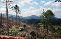
 Plot of Douglas fir trees overturned by the Lothar storm on December 26, 1999, in the forest of Fréteval, Loir-et-Cher, France.


Post-Lothar[edit]
The Schliffkopf region in the Black Forest is located in Baden-Württemberg, Germany. It is known for its forests and groundwater reservoirs and has been a protected nature reserve since 1938.
At the end of June 2003, a 800 m long observation trail called the "Lotharpfad" was opened on the site. The Lothar storm, with hurricane-force winds reaching 272 km/h on Mount Hohentwiel north of Lake Constance, heavily impacted the region in 1999, and visitors to this observation trail can discover nearly 10 hectares (100,000 m2) devastated by the storm.[citation needed]
References[edit]
- ^ a b "Une situation météorologique exceptionnelle". Tempêtes de décembre 1999. Archived from the original on 2016-03-04. Retrieved 4 August 2016.
- ^ a b "Bewertung der Orkanwetterlage am 26.12.1999 aus klimatologischer Sicht" (PDF). Deutscher Wetterdienst (in German). Retrieved 9 January 2016.
- ^ "Wetterextreme". unwetterzentrale.de (in German). Retrieved 26 May 2015.
- ^ "Three extreme storms over Europe in December 1999". Université de Cologne. 2001. Archived from the original on 2012-03-02.
- ^ a b c d e f g h i "Les tempêtes Lothar et Martin" (PDF). Risk management Solutions (RMS). Retrieved 15 March 2015.
- ^ a b c "Lothar - 10 ans après". MétéoSuisse. 2009. Archived from the original on 2014-12-15. Retrieved 6 March 2015.
- ^ a b c d "Looking Back, Looking Forward: Anatol, Lothar and Martin Ten Years Later". Air-Worldwide. Retrieved 19 April 2015.
- ^ Baleste, Marie-Claire; Brunet, Hubert; Mougel, Alain. "Les tempêtes exceptionnelles de Noël 1999". Météo-France/ Direction de la Production. Bulletin climatique annuel. ISSN 1159-1056.
- ^ "Bulletin climatique" (PDF). Météo-France. 1999. Retrieved 16 March 2015.
- ^ "Aspects méthodologiques et historiques des tempêtes et des chablis".
- ^ "Lothar le 26 décembre 1999". Météo-France. Retrieved 28 January 2017.
- ^ "Tempête d'ouest et températures record" (PDF).
- ^ a b "Tempête du 26 décembre 1999".
- ^ Spicher, Michel (2004). "L'ouragan Lothar, un cataclysme dans le monde forestier". Site officiel du Canton de Fribourg. Retrieved 6 March 2015.
- ^ Denis, Michel (2004). "Expertise collective suite aux dégâts en forêt lors des tempêtes de décembre 1999". Archived from the original on 2006-02-19.
- ^ Hontarrède, M. (2000). "Les tempêtes jumelles de Noël 1999". Revue Met-Mar (187).
- ^ Chaboud, R. (1994). La météo, questions de temps (in French). Éditions Nathan. ISBN 9782092605400.