Shpykiv
Shpykiv | |
|---|---|
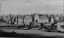
 Świejkowski Palace in the 19th century | |
| Coordinates: 48°47′N 28°34′E / 48.783°N 28.567°E | |
| Country | |
| Province | |
| District | |
| Founded | 1507 |
| Area | |
| • Total | 45 km2 (17 sq mi) |
| Population (2022) | |
| • Total | 2,917 |
| • Density | 65/km2 (170/sq mi) |
| Time zone | UTC+2 (EET) |
| • Summer (DST) | UTC+3 (EEST) |
Shpykiv (Ukrainian: Шпи́ків, Polish: Szpików) is an urban-type settlement in Tulchyn Raion (a district in Vinnytsia Oblast (province) in central Ukraine, 372 kilometers (231 mi) southwest of Kyiv and 24 km (15 mi) northwest of Tulchyn, the raion center. Population: 2,917 (2022 estimate)[1]. It is located in the historic region of Podolia.
History[edit]
This section needs additional citations for verification. (April 2022) |
Spykov was first mentioned in documents dating from the 16th century during the Polish-Lithuanian period. Its first owners were gentry, one of whom sold Spykov to the princes of Ostrozky.
Until the Second partition of Poland Szpików was part of the Bracław Voivodeship of the Lesser Poland Province of the Polish Crown. It was a small town, owned by the houses of Ostrogski, Zamoyski, Koniecpolski, Potocki and Świejkowski.[2] Leonard Marcin Świejkowski built a Baroque palace in Szpików.
From 1793 to 1917 it was a town in Bratslav uyezd in Podolian Governorate of the Russian Empire. It formerly had a significant Jewish community, which numbered 1,875 in 1900. In January 1989, the population was 4,285 people[3] In January 2013, the population was 3,355 people.[4]
References[edit]
- ^ Чисельність наявного населення України на 1 січня 2022 [Number of Present Population of Ukraine, as of January 1, 2022] (PDF) (in Ukrainian and English). Kyiv: State Statistics Service of Ukraine. Archived (PDF) from the original on 4 July 2022.
- ^ Geographical Dictionary of the Kingdom of Poland, vol. 12, p. 29
- ^ Всесоюзная перепись населения 1989 г. Численность городского населения союзных республик, их территориальных единиц, городских поселений и городских районов по полу
- ^ Чисельність наявного населення України на 1 січня 2013 року. Державна служба статистики України. Київ, 2013. стор.44


