
Sevelinges
Sevelinges | |
|---|---|
Commune | |
 An panoramic view of Sevelinges | |
.svg) Coat of arms | |
Location of Sevelinges  | |
 Sevelinges  Sevelinges | |
| Coordinates: 46°05′57″N 4°17′48″E / 46.0992°N 4.2967°E | |
| Country | France |
| Region | Auvergne-Rhône-Alpes |
| Department | Loire |
| Arrondissement | Roanne |
| Canton | Charlieu |
| Government | |
| • Mayor (2020–2026) | Dominique Palluet[1] |
| Area 1 | 8.19 km2 (3.16 sq mi) |
| Population (2021)[2] | 648 |
| • Density | 79/km2 (200/sq mi) |
| Time zone | UTC+01:00 (CET) |
| • Summer (DST) | UTC+02:00 (CEST) |
| INSEE/Postal code | 42300 /42460 |
| Elevation | 397–682 m (1,302–2,238 ft) (avg. 570 m or 1,870 ft) |
| 1 French Land Register data, which excludes lakes, ponds, glaciers > 1 km2 (0.386 sq mi or 247 acres) and river estuaries. | |
Sevelinges (French pronunciation: [səvlɛ̃ʒ]) is a commune in the Loire department in central France.
Population[edit]
| Year | Pop. | ±% p.a. |
|---|---|---|
| 1968 | 600 | — |
| 1975 | 502 | −2.52% |
| 1982 | 503 | +0.03% |
| 1990 | 584 | +1.88% |
| 1999 | 582 | −0.04% |
| 2009 | 642 | +0.99% |
| 2014 | 651 | +0.28% |
| 2020 | 646 | −0.13% |
| Source: INSEE[3] | ||
-
 Sevelinges, view from the south, in autumn
 -
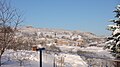 Sevelinges, view from the south, in winter
 -
 Sevelinges, view from the north-east


See also[edit]
References[edit]
- ^ "Répertoire national des élus: les maires". data.gouv.fr, Plateforme ouverte des données publiques françaises (in French). 9 August 2021.
- ^ "Populations légales 2021". The National Institute of Statistics and Economic Studies. 28 December 2023.
- ^ Population en historique depuis 1968, INSEE
Wikimedia Commons has media related to Sevelinges.
| Authority control databases: National |
|---|
This Loire geographical article is a stub. You can help Wikipedia by expanding it. |