
Serra dos Ancares
| Serra dos Ancares | |
|---|---|
| Sierra de los Ancares | |
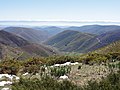
 General view of the range | |
| Highest point | |
| Peak | Cuiña |
| Elevation | 1,987 m (6,519 ft) |
| Coordinates | 42°46′05″N 6°53′53″W / 42.76806°N 6.89806°W |
| Dimensions | |
| Length | 95 km (59 mi) NE/SW |
| Width | 32 km (20 mi) NW/SE |
| Geography | |
 Serra dos Ancares Location in Spain | |
| Location | Lugo Province, Galicia León Province, Castile and León |
| Country | Spain |
| Parent range | Galician Massif |
| Geology | |
| Orogeny | Variscan orogeny |
| Age of rock | Ordovician |
| Type of rock | Slate, limestone, sandstone, quartzite |
The Serra dos Ancares (Spanish: Sierra de los Ancares, also known as Sierra de Ancares) is a mountain range of the Galician Massif in north-west Spain, extending in a south-westerly direction from the western end of the Cantabrian Mountains in Asturias.
Geography[edit]
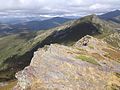
The range forms the boundary between the autonomous communities of Galicia and Castile and León. The highest point of the range is the Cuiña Peak at 1,987 metres (6,519 ft). Other notable peaks are Mustallar (1,935 m) and Miravalles (1,969 m). The smaller Serra do Courel lies south of this range, stretching parallel to it.
The main trees in the range are willow and European alder close to water courses, as well as chestnut, ash, common hazel, oak and common holly. Above 1,600 metres (5,200 ft) there is brushland with tree heath and juniper.[1]
This area of Spain contains many isolated rural communities that were largely cut off from the outside world until roads were built in the mid 20th century. The most significant element of the whole architecture of the area is the palloza or casa teito, stone buildings of ancient origin, with a circular or elliptical plan.
Ecology[edit]
Sierra de los Ancares is the name of a Site of Community Importance in the province of León.[2]
Os Ancares Lucenses y Montes de Cervantes, Navia y Becerrea was declared a UNESCO Biosphere Reserve in 2006.[3][4] Los Ancares Leoneses is also a biosphere reserve.
-
 Serra dos Ancares (Lugo)
 -
 Serra dos Ancares (Lugo)
 -
 Serra dos Ancares (León)
 -
 Serra dos Ancares (León)
_09.JPG)
_06.JPG)
_-_lago_en_el_camino_hacia_el_Cui%C3%B1a.JPG)
_-_vistas_subiendo_al_Pico_Miravalles.jpg)
See also[edit]
References[edit]
- ^ González Arias, Alejandro,Guía e rutas dos Ancares, Vigo: Editorial Galaxia, 1995, pp 13-14
- ^ Sierra de los Ancares Archived 2011-09-06 at the Wayback Machine, Urugallo cantábrico website. According to this source, the SCI covers the same area as a regional hunting reserve.
- ^ "Os Ancares..." UNESCO. Retrieved 19 July 2016.
- ^ Os Ancares UNESCO-MAB Biosphere Reserve