Schalls, Missouri
Schalls, Missouri. | |
|---|---|
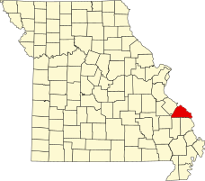
 Location of Perry County, Missouri | |
| Coordinates: 37°40′01″N 89°41′11″W / 37.66694°N 89.68639°W | |
| Country | United States |
| State | Missouri |
| County | Perry |
| Township | Union |
| Elevation | 620 ft (189[1] m) |
| Time zone | UTC-6 (Central (CST)) |
| • Summer (DST) | UTC-5 (CDT) |
| ZIP code | 63775 |
| Area code | 573 |
| GNIS feature ID | 726093[2] |
Schalls is an unincorporated community in Union Township in Perry County, Missouri, United States.[3] Schalls is situated in the north-central corner of Perry County. A post office was maintained from 1886 through 1910. The community was named after Maritz Schall, a pioneer stock dealer and farmer.[3][4][5]
References[edit]
- ^ Cartographic.usa http://cartographic.info/usa/map.php?id=726093
- ^ National Explorer http://nationexplorer.com/feature/726093
- ^ a b State Historical Society of Missouri: Perry County http://shs.umsystem.edu/manuscripts/ramsay/ramsay_perry.html
- ^ A Directory of Towns, Villages, and Hamlets Past and Present of Perry County, Missouri "A Directory of Towns, Villages, and Hamlets of Missouri". Archived from the original on November 3, 2013. Retrieved November 26, 2013.
- ^ Eaton, David Wolfe (1917). How Missouri Counties, Towns and Streams Were Named. The State Historical Society of Missouri. pp. 338.

