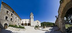
Sant Mateu
Sant Mateu | |
|---|---|
 | |
| Coordinates: 40°27′54″N 0°10′49″E / 40.46500°N 0.18028°E | |
| Country | |
| Autonomous community | |
| Province | Castelló |
| Comarca | Baix Maestrat |
| Judicial district | Vinaròs |
| Area | |
| • Total | 64.6 km2 (24.9 sq mi) |
| Elevation | 325 m (1,066 ft) |
| Population (2018)[1] | |
| • Total | 1,974 |
| • Density | 31/km2 (79/sq mi) |
| Demonym(s) | Santmatevà, santmatevana |
| Time zone | UTC+1 (CET) |
| • Summer (DST) | UTC+2 (CEST) |
| Postal code | 12170 |
| Official language(s) | Valencian |

Sant Mateu is a town and municipality in eastern Spain, in the province of Castellón, part of the autonomous community of Valencia.
Sights[edit]
The most interesting sights in Sant Mateu are:
- Església arxiprestal church building.
- Ermita de la Mare de Déu dels Àngels de Sant Mateu located in the Serra de la Vall d'Àngel mountain range east of the town.
References[edit]
- ^ Municipal Register of Spain 2018. National Statistics Institute.
External links[edit]
Wikimedia Commons has media related to Sant Mateu.
- Ajuntament de Sant Mateu
- Paco González Ramírez - País Valencià, poble a poble, comarca a comarca
- Institut Valencià d'Estadística.
- Portal de la Direcció General d'Administració Local de la Generalitat.


