
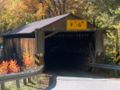
Riverdale Road Covered Bridge
Riverdale Road Bridge | |
|---|---|
_Covered_Bridge_1.jpg) | |
| Coordinates | 41°40′24″N 80°52′19″W / 41.67333°N 80.87194°W |
| Locale | Ashtabula County, Ohio, United States |
| Characteristics | |
| Design | single span, Town truss |
| Total length | 140 feet (42.7 m) |
| History | |
| Construction start | 1874 |
| Location | |
 | |
Riverdale Road Bridge is a covered bridge spanning the Grand River in Morgan Township, Ashtabula County, Ohio, United States. The bridge, one of currently 16 drivable bridges in Ashtabula county, is a single span Town truss design. During its renovation in 1981, the floor was rebuilt and glue-laminated wood girders were added. Previously, center steel bracing had been replaced under the bridge in 1945. In 1987, a new concrete abutment for additional support was added after the road at the east end of the bridge washed out.[1] The bridge’s WGCB number is 35-04-22,[2] and it is located approximately 1.1 mi (1.8 km) north-northwest of Rock Creek.
History[edit]
- 1874 – Bridge constructed[1]
- 1945 – Center steel bracing replaced[1]
- 1981 – Bridge renovated[1]
- 1987 – Concrete abutment added at west end after road washed out[1]
Dimensions[edit]
- Span: 111 feet (34 m)
- Length: 140 feet (43 m)
- Width: 12 feet 6 inches (3.81 m)
- Height: 10 feet 6 inches (3.20 m)
- Overhead clearance: 9 feet 6 inches (2.90 m)
Gallery[edit]
-
 View from the southeast
 -
 East approach
 -
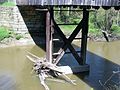 View from underneath the bridge
 -

-

_Covered_Bridge_2.jpg)

.jpg)

See also[edit]
References[edit]
- ^ a b c d e "Ashtabula County Ohio Covered Bridge Festival". Archived from the original on 2006-12-07. Retrieved 2006-11-20. Ashtabula County Ohio Covered Bridge Festival
- ^ http://www.dalejtravis.com/bridge/ohio/htm/3500422.htm Ohio Covered Bridges List, 35-04-22
External links[edit]
- Ohio Covered Bridges List
- Ohio Historic Bridge Association
- "Riverdale Bridge". Geographic Names Information System. United States Geological Survey. Retrieved 2012-12-30.
| Authority control databases: Geographic |
|---|