Richmond-Westmoreland Streets Loop
Richmond and Westmoreland | |||||||||||||
|---|---|---|---|---|---|---|---|---|---|---|---|---|---|
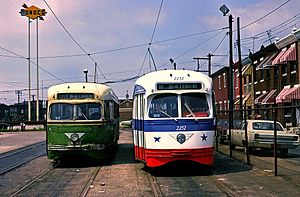
 Two PCC streetcars at the Richmond-Westmoreland Loop in May 1976. | |||||||||||||
| General information | |||||||||||||
| Location | Richmond and Westmoreland Street Philadelphia, Pennsylvania | ||||||||||||
| Owned by | SEPTA | ||||||||||||
| Line(s) | |||||||||||||
| Platforms | sidewalk platform | ||||||||||||
| Tracks | 2 | ||||||||||||
| History | |||||||||||||
| Electrified | Overhead lines | ||||||||||||
| |||||||||||||
The Richmond & Westmoreland Streets Loop (soon to be known as Richmond–Westmoreland station[1]) is a turning loop located in the Port Richmond section of Philadelphia, Pennsylvania. The transit loop was built on part of the former PTC's Richmond Carhouse/Depot and is operated by the Southeastern Pennsylvania Transportation Authority (SEPTA), which is located between Allegheny Avenue and Westmoreland Street. The transit loop serves as a terminus for several transit routes.
The transit routes that serve this terminus run to various parts of the City of Philadelphia.[2]
The transit lines that run from this loop are SEPTA Route 15, SEPTA Route 60 and SEPTA Route 73. These lines operate from three SEPTA Depots located around Philadelphia.
References[edit]
- ^ "SEPTA Metro Network Map" (PDF). September 19, 2023. Retrieved 7 April 2024.
- ^ "Stations & Stops | SEPTA". Southeastern Pennsylvania Transportation Authority. Retrieved 2023-03-30.
External links[edit]
 Media related to Westmoreland Street Loop at Wikimedia Commons
- SEPTA Route 15
- SEPTA Route 60
- SEPTA Route 73
