
Ravanna, Kansas
Ravanna, Kansas | |
|---|---|
 | |
| Coordinates: 38°09′35″N 100°22′57″W / 38.15972°N 100.38250°W[1] | |
| Country | United States |
| State | Kansas |
| County | Finney |
| Founded | 1882 |
| Elevation | 2,559 ft (780 m) |
| Population | |
| • Total | 0 |
| Time zone | UTC-6 (CST) |
| • Summer (DST) | UTC-5 (CDT) |
| Area code | 620 |
| FIPS code | 20-58530 [1] |
| GNIS ID | 484567 [1] |

Ravanna is a ghost town in Finney County, Kansas, United States.[1] It is located approximately 30 miles (48 km) east-northeast of Garden City.
History[edit]
Ravanna was founded in 1882.[2]
In 1887, it was one of two towns that vied to become the county seat of the now defunct Garfield County, which merged into Finney County in 1893.[3]
The post office in Ravanna closed permanently in 1922.[4]
Geography[edit]
Climate[edit]
According to the Köppen Climate Classification system, Ravanna has a semi-arid climate, abbreviated "BSk" on climate maps.[5]
References[edit]
- ^ a b c d e "Ravanna, Kansas", Geographic Names Information System, United States Geological Survey, United States Department of the Interior
- ^ "Finney County". Blue Skyways. Kansas State Library. Retrieved June 10, 2014.
- ^ "Ravanna Kansas, former county seat of Garfield County, now a Finney County ghost town". Retrieved June 20, 2016.
- ^ "Kansas Post Offices, 1828-1961 (archived)". Kansas Historical Society. Archived from the original on October 9, 2013. Retrieved June 10, 2014.
- ^ Climate Summary for Ravanna, Kansas
Further reading[edit]
External links[edit]
Municipalities and communities of Finney County, Kansas, United States | ||
|---|---|---|
| Cities | 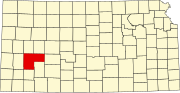 | |
| Unincorporated communities | ||
| Ghost towns | ||
| Townships | ||
| Footnotes | †This community is designated a Census-Designated Place (CDP) by the United States Census Bureau. | |
This article about a location in Finney County, Kansas is a stub. You can help Wikipedia by expanding it. |