
Quebec Route 232
Route 232 | ||||
|---|---|---|---|---|
 | ||||
| Route information | ||||
| Maintained by Transports Québec | ||||
| Length | 142.0 km[1] (88.2 mi) | |||
| Major junctions | ||||
| West end | ||||
| East end | ||||
| Location | ||||
| Country | Canada | |||
| Province | Quebec | |||
| Major cities | Rimouski | |||
| Highway system | ||||
| ||||

Route 232 is a two-lane east/west provincial highway on the south shore of the St. Lawrence River in the Bas-Saint-Laurent region of Eastern Quebec, Canada. Its eastern terminus is in Rimouski at the junction of Route 132 and the western terminus is at the junction of Route 289 in Rivière-Bleue. The route temporarily becomes A-85 along a 3 kilometre section through Cabano.
Municipalities along Route 232[edit]
- Rimouski
- Sainte-Blandine
- Mont-Lebel
- La Trinité-des-Monts
- Esprit-Saint
- Lac-des-Aigles
- Cabano
-
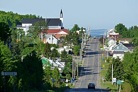
 Route 232 runs through Lac-des-Aigles.
 -
 Hilly section between Rimouski and Témiscouata-sur-le-Lac, part of route des Monts-Notre-Dame.


See also[edit]
References[edit]
- ^ Ministère des transports, "Distances routières", page 86, Les Publications du Québec, 2005
External links[edit]
- Provincial Route Map (Courtesy of the Quebec Ministry of Transportation) (in French)
- Route 232 on Google Maps
47°49′40″N 68°40′02″W / 47.8279°N 68.6673°W
This Quebec road, road transport or highway-related article is a stub. You can help Wikipedia by expanding it. |