Prelesje, Gorenja Vas–Poljane
Prelesje | |
|---|---|
 | |
| Coordinates: 46°4′9.44″N 14°11′17.94″E / 46.0692889°N 14.1883167°E | |
| Country | |
| Traditional region | Upper Carniola |
| Statistical region | Upper Carniola |
| Municipality | Gorenja Vas–Poljane |
| Area | |
| • Total | 1.16 km2 (0.45 sq mi) |
| Elevation | 650.5 m (2,134.2 ft) |
| Population (2020) | |
| • Total | 74 |
| • Density | 64/km2 (170/sq mi) |
| [1] | |
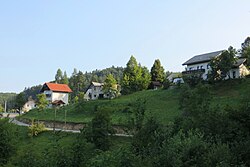
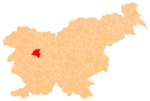
Prelesje (pronounced [pɾɛˈleːsjɛ]) is a small settlement near the village of Lučine in the Municipality of Gorenja Vas–Poljane in the Upper Carniola region of Slovenia.[2]
Name[edit]
The name Prelesje is a fused prepositional phrase that has lost case inflection: pre(d) 'before, in front of' + lesje 'woods', referring to its location relative to forested land. Prelesje was attested in older sources as Prilezzi in 1291 and Prilessi in 1500,[3] and the name was transcribed as Perleſsie on the Franciscan land survey of 1818–1828.[4]
Gallery[edit]
-
Wayside shrine south of the main part of Prelesje
References[edit]
- ^ Statistical Office of the Republic of Slovenia
- ^ Gorenja Vas–Poljane municipal site
- ^ "Prelesje". Slovenska historična topografija. ZRC SAZU Zgodovinski inštitut Milka Kosa. Retrieved August 26, 2020.
- ^ "Franciscejski kataster za območje Slovenije". Register kulturne dediščine. Arhiv Republike Slovenije. Retrieved August 26, 2020.
External links[edit]
 Media related to Prelesje at Wikimedia Commons
- Prelesje on Geopedia


