
Portal:Kent/Sandbox
DesktopMobile
Test of: Transclude files as random slideshow/sandbox
-
 Hand-drawn map of Kent, Sussex, Surrey and Middlesex from 1575. (from Kent)
 -
-
 Canterbury Cathedral (from Kent)
 -
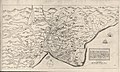 A map of Romney Marsh "The history of imbanking and drayning" by William Dugdale (1662). (from Kent)
 -
 The White Cliffs of Dover (from Kent)
 -
 View of the White Cliffs of Dover from France (from Kent)
 -

-
 An early mention of Kent in the Anglo-Saxon Chronicle between 11th and 12th centuries (from Kent)
 -
-
 Geological cross-section of Kent, showing how it relates to major towns (from Kent)
 -

-
 The coat of arms of Kent County Council (from Kent)
 -

-
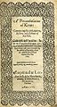 Title page of William Lambarde's Perambulation of Kent (completed in 1570 and published in 1576), a historical description of Kent and the first published county history (from Kent)
 -


.jpg)


Apr2006.jpg)


Test of: Transclude linked excerpts as random slideshow/sandbox
-
 Bexley is an area of south-eastern Greater London, England and part of the London Borough of Bexley. It is sometimes known as Bexley Village or Old Bexley to differentiate the area from the wider borough. It is located 13 miles (21 km) east-southeast of Charing Cross and south of Bexleyheath. (Full article...)
 -
Getlink, formerly Groupe Eurotunnel, is a European public company based in Paris that manages and operates the infrastructure of the Channel Tunnel between France and the United Kingdom, operates the LeShuttle railway service, and earns revenue on other trains that operate through the tunnel (Eurostar passenger and DB Schenker freight). (Full article...)
-
Essex (/ˈɛsɪks/ ESS-iks) is a ceremonial county in the East of England, and one of the home counties. It is bordered by Cambridgeshire and Suffolk to the north, the North Sea to the east, Kent across the Thames Estuary to the south, Greater London to the south-west, and Hertfordshire to the west. The largest settlement is Southend-on-Sea, and the county town is Chelmsford. (Full article...)
-
The County Ground, Beckenham is a cricket ground in Beckenham in the London Borough of Bromley. The ground is owned by Leander Sports and Leisure and is used as an outground by Kent County Cricket Club for First XI fixtures, as well as for other matches. As of 2019 the Kent Women cricket team played the majority of their matches at the ground. (Full article...)
-
Oxford University Press (OUP) is the publishing house of the University of Oxford. It is the largest university press in the world. The first book was printed in Oxford in 1478, with the Press officially granted the legal right to print books by decree in 1586. It is the second oldest university press after Cambridge University Press, which was founded in 1534. (Full article...)
-
Gravesend /ˌɡreɪvzˈɛnd/ is a town in northwest Kent, England, situated 21 miles (35 km) east-southeast of Charing Cross (central London) on the south bank of the River Thames and opposite Tilbury in Essex. Located in the diocese of Rochester, it is the administrative centre of the borough of Gravesham. Gravesend marks the eastern limit of the Greater London Built-up Area, as defined by the UK Office for National Statistics. In 2021 it had a population of 58,102. (Full article...)
-
The Labour Party is a political party in the United Kingdom that has been described as an alliance of social democrats, democratic socialists, and trade unionists. The Labour Party sits on the centre-left of the political spectrum. In all general elections since 1922, Labour has been either the governing party or the Official Opposition. There have been six Labour prime ministers and thirteen Labour ministries. Since the 2010 general election, it has been the second-largest UK political party by the number of votes cast, behind the Conservative Party and ahead of the Liberal Democrats. The party holds the annual Labour Party Conference. (Full article...)
-
Papermaking is the manufacture of paper and cardboard, which are used widely for printing, writing, and packaging, among many other purposes. Today almost all paper is made using industrial machinery, while handmade paper survives as a specialized craft and a medium for artistic expression. (Full article...)
-
Priestfield Stadium (popularly known simply as Priestfield and officially known from 2007 to 2010 as KRBS Priestfield Stadium and from 2011 as MEMS Priestfield Stadium for sponsorship purposes) is a football stadium in Gillingham, Kent. It has been the home of Gillingham Football Club since the club's formation in 1893, and was also the temporary home of Brighton & Hove Albion Football Club for two seasons during the 1990s. The stadium has also hosted women's and youth international football matches and a London Broncos rugby league match. (Full article...)
-
The Kent Downs is an Area of Outstanding Natural Beauty (AONB) in Kent, England. They are the eastern half of the North Downs and stretch from the London/Surrey borders to the White Cliffs of Dover, including a small section of the London Borough of Bromley. The AONB also includes the Greensand Ridge, a prominent sandstone escarpment which lies south of the chalk escarpment of the North Downs. (Full article...)
-
Domesday Book (/ˈduːmzdeɪ/ DOOMZ-day; the Middle English spelling of "Doomsday Book") is a manuscript record of the Great Survey of much of England and parts of Wales completed in 1086 at the behest of King William the Conqueror. The manuscript was originally known by the Latin name Liber de Wintonia, meaning "Book of Winchester", where it was originally kept in the royal treasury. The Anglo-Saxon Chronicle states that in 1085 the king sent his agents to survey every shire in England, to list his holdings and dues owed to him. (Full article...)
-
The Dartford–Thurrock River Crossing, commonly known as the Dartford Crossing and until 1991 the Dartford Tunnel, is a major road crossing of the River Thames in England, carrying the A282 road between Dartford in Kent in the south and Thurrock in Essex in the north. (Full article...)
-
A hundred is an administrative division that is geographically part of a larger region. It was formerly used in England, Wales, some parts of the United States, Denmark, Southern Schleswig, Sweden, Finland, Norway, the Bishopric of Ösel–Wiek, Curonia, the Ukrainian state of the Cossack Hetmanate and in Cumberland County in the British Colony of New South Wales. It is still used in other places, including in Australia (in South Australia and the Northern Territory). (Full article...)
-
Old English (Englisċ, pronounced [ˈeŋɡliʃ]), or Anglo-Saxon, is the earliest recorded form of the English language, spoken in England and southern and eastern Scotland in the early Middle Ages. It developed from the languages brought to Great Britain by Anglo-Saxon settlers in the mid-5th century, and the first Old English literary works date from the mid-7th century. After the Norman Conquest of 1066, English was replaced for several centuries by Anglo-Norman (a type of French) as the language of the upper classes. This is regarded as marking the end of the Old English era, since during the subsequent period the English language was heavily influenced by Anglo-Norman, developing into what is now known as Middle English in England and Early Scots in Scotland. (Full article...)
-
The Parliament of the United Kingdom of Great Britain and Northern Ireland is the supreme legislative body of the United Kingdom, and may also legislate for the Crown Dependencies and the British Overseas Territories. It meets at the Palace of Westminster in London. Parliament possesses legislative supremacy and thereby holds ultimate power over all other political bodies in the United Kingdom and the Overseas Territories. While Parliament is bicameral, it has three parts: the sovereign, the House of Lords, and the House of Commons. The three parts acting together to legislate may be described as the King-in-Parliament. The Crown normally acts on the advice of the prime minister, and the powers of the House of Lords are limited to only delaying legislation; thus power is de facto vested in the House of Commons. (Full article...)
-
Folkestone (/ˈfəʊkstən/ FOHK-stən) is a port town on the English Channel, in Kent, south-east England. The town lies on the southern edge of the North Downs at a valley between two cliffs. It was an important harbour, shipping port and fashionable coastal resort for most part of the 19th and mid 20th centuries. (Full article...)
-
Northfleet is a town in the borough of Gravesham in Kent, England. It is located immediately west of Gravesend, and on the border with the Borough of Dartford. Northfleet has its own railway station on the North Kent Line, just east of Ebbsfleet International railway station on the High Speed 1 line. According to the 2021 census, Northfleet has a population of 29,900 (rounded to the nearest 100). (Full article...)
-
Medway is borough and unitary authority area in Kent, South East England. It had a population of 278,016 in 2019. The unitary authority was formed in 1998, when the boroughs of Rochester-upon-Medway and Gillingham were merged to form Medway Towns. The borough is governed by Medway Council, a unitary authority which is independent of Kent County Council, but remains part of the ceremonial county of Kent. (Full article...)
-
Tonbridge (/ˈtʌnbrɪdʒ/ TUN-brij) (historic spelling Tunbridge) is a market town in Kent, England, on the River Medway, 4 miles (6 km) north of Royal Tunbridge Wells, 12 miles (19 km) south west of Maidstone and 29 miles (47 km) south east of London. In the administrative borough of Tonbridge and Malling, it had an estimated population of 41,293 in 2019. (Full article...)
-
Greensand or green sand is a sand or sandstone which has a greenish color. This term is specifically applied to shallow marine sediment that contains noticeable quantities of rounded greenish grains. These grains are called glauconies and consist of a mixture of mixed-layer clay minerals, such as smectite and glauconite. Greensand is also loosely applied to any glauconitic sediment. (Full article...)
-
Gillingham Football Club is a professional association football club based in the town of Gillingham, Kent, England. The only Kent-based club in the Football League, the "Gills" play their home matches at Priestfield Stadium. The team competes in League Two, the fourth tier of the English football league system, in the 2023–24 season. (Full article...)
-
Eltham (/ˈɛltəm/ EL-təm) is a district of southeast London, England, within the Royal Borough of Greenwich. It is 8.7 miles (14.0 km) east-southeast of Charing Cross, and is identified in the London Plan as one of 35 major centres in Greater London. The three wards of Eltham North, South and West have a total population of 35,459. 88,000 people live in Eltham. (Full article...)
-
Allington is an almost entirely modern village situated alongside the sides of the A20 road west of Maidstone in Kent, England. It is part of the built-up area of Maidstone. (Full article...)
