Pont del Diable
Pont del Diable (Devil's Bridge) | |
|---|---|
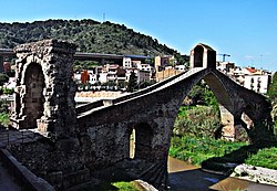
 Pont del Diable, with the Roman arch at left | |
| Coordinates | 41°28′30″N 1°56′16″E / 41.474981°N 1.93764°E |
| Crosses | Llobregat |
| Locale | Martorell-Castellbisbal, Catalonia, Spain |
| Characteristics | |
| Design | Arch bridge |
| Material | Stone |
| Longest span | 37.3 m |
| History | |
| Construction end | 1283 |
| Location | |
 | |

The Pont del Diable (Spanish: Puente del Diablo, English: Devil's bridge), also known as Sant Bartomeu Bridge,[1] is a medieval bridge crossing the river Llobregat and straddling the municipalities of Martorell and Castellbisbal in Catalonia, Spain. The bridge is restricted to pedestrians.
The present bridge, featuring a large pointed arch, is a 1965 reconstruction of the gothic bridge built in 1283 on Roman foundations. The main clear span is 37.3 metres (122 ft) with a stone chapel on top.[2][3] A secondary arch has a span of 19.1 metres (63 ft). The bridge was destroyed in 1939 during the Spanish Civil War by retreating Republican troops, but rebuilt in 1965 in a form generally similar to the gothic structure.[2] It is now surrounded on three sides by road flyovers and railway lines.
The original Roman bridge formed a part of the Via Augusta, and was the only bridge in the lower Llobregat valley until the 14th century.[4] It still features a Roman triumphal arch at its eastern abutment. It is unclear how many spans the original Roman bridge had.[2]
See also[edit]
References[edit]
- ^ "Devil's Bridge at Martorell". Structurae. 2013-10-07. Retrieved 2013-12-06.
- ^ a b c O’Connor 1993, pp. 102f.
- ^ Structurae notes 43 metres (141 ft), but does not specify whether the value refers to the clear span or the span between the centerline of the piers (Puente del Diablo (Martorell) at Structurae).
- ^ "Pont del Diable". Pobles de Catalunya. Retrieved 2013-12-06.
Sources[edit]
- O’Connor, Colin (1993), Roman Bridges, Cambridge University Press, pp. 102f., ISBN 0-521-39326-4
