
Pléneau Island

Pléneau Island (65°6′S 64°3′W / 65.100°S 64.050°W) is an island, 0.8 nautical miles (1.5 km) long, lying just northeast of Hovgaard Island in the Wilhelm Archipelago, Charted as a peninsula of Hovgaard Island by the French Antarctic Expedition, 1903–05, under J.B. Charcot, who named its northeast point for Paul Pléneau, photographer of the expedition. The feature was first shown to be an island on an Argentine government chart in 1957.
-
 Kayakers around Pléneau Island
 -
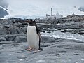 Gentoo penguin on Pléneau Island
 -
 Gentoo penguin and chicks on Pléneau Island
 -
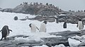 Gentoo penguin colony on Pléneau Island
 -
 Scientist counts Gentoo penguins on Pléneau Island
 -
 Pléneau Island


See also[edit]
References[edit]
![]() This article incorporates public domain material from "Pléneau Island". Geographic Names Information System. United States Geological Survey.
This article incorporates public domain material from "Pléneau Island". Geographic Names Information System. United States Geological Survey.
Further reading[edit]
This Wilhelm Archipelago location article is a stub. You can help Wikipedia by expanding it. |