Pengkalan Kempas
Pengkalan Kempas
Pongkalan Kompeh | |
|---|---|
Hamlet | |
| Other transcription(s) | |
| • Jawi | ڤڠكالن كمڤاس |
| • Chinese | 船头 |
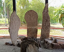
 Ancient standing stones in Pengkalan Kempas, Negeri Sembila | |
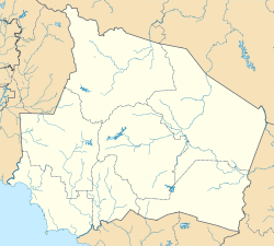
| Coordinates: 2°27′N 102°01′E / 2.450°N 102.017°E | |
| Country | |
| State | |
| District | Port Dickson |
| Luak | Linggi |
| Elevation | 20 m (70 ft) |
| Time zone | UTC+8 (MYT) |
| Postal code | 71150 |
Pengkalan Kempas (Negeri Sembilan Malay: Pongkalan Kompeh; Jawi: ڤڠكالن كمڤاس; Chinese: 船头) is a hamlet in Port Dickson District, Negeri Sembilan, Malaysia. The Pengkalan Kempas Historical Complex is located here. It is also called Keramat Ujung Pasir.
Pengkalan Kempas Historical Complex[edit]
Located about 23 km from the Cape Rachado (Tanjung Tuan) lighthouse and 34 km from Port Dickson town. Here you will find a 15th-century tomb of a historical personality, Ulama Sheikh Ahmad Majanu, with its famous carved megalith.[1] Next to his grave are the famous stone inscriptions or "Batu Bersurat" which depict his struggle and victory. The enigma surrounding the stone remains unsolved to this day. Of special interest is the ‘ordeal stone’, an ancient lie-detector, through which a person puts his arm when answering questions. If he lies, the stone tightens like a vice.
References[edit]
- ^ de CASPARIS, J. G. (1980). "Ahmat Majanu's Tombstone at Pengkalan Kempas and Its Kawi Inscription". Journal of the Malaysian Branch of the Royal Asiatic Society. 53 (1 (237)): 1–22. ISSN 0126-7353.


