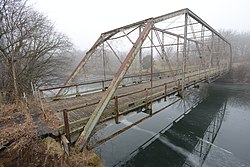
Otranto Bridge
Otranto Bridge | |
Formerly listed on the U.S. National Register of Historic Places | |
 | |
| Location | 480th Ave. over the Big Cedar River |
|---|---|
| Nearest city | St. Ansgar, Iowa |
| Coordinates | 43°27′29″N 92°58′55″W / 43.45806°N 92.98194°W |
| Area | less than one acre |
| Built | 1899 |
| Built by | Chicago Bridge and Iron Company |
| Architect | Horace E. Horton |
| Architectural style | Camelback truss |
| MPS | Highway Bridges of Iowa MPS |
| NRHP reference No. | 98000495[1] |
| Significant dates | |
| Added to NRHP | May 15, 1998 |
| Removed from NRHP | October 20, 2020 |
The Otranto Bridge was located northwest of St. Ansgar, Iowa, United States. It carried traffic on 480th Avenue over the Cedar River for 170 feet (52 m).[2] The supervisors from Mitchell County contracted with the Chicago Bridge and Iron Company (CBI) to build two bridges in the county. Chicago engineer Horace E. Horton from CBI designed this Camelback through truss bridge. It replaced and older span at the same location, and it was completed in 1899 for $3,257.[2] The Otranto Bridge was one of the few Camelback through truss bridges built in Iowa.[2] It was replaced by a modern bridge and was privately owned before being dismantled.
The bridge was listed on the National Register of Historic Places in 1998.[1] It was removed in 2020.[3]
References[edit]
- ^ a b "National Register Information System". National Register of Historic Places. National Park Service. March 13, 2009.
- ^ a b c John Lauber. "Otranto Bridge". National Park Service. Retrieved May 13, 2016. with one photo from 1998
- ^ "National Register of Historic Places Program: Weekly List". National Park Service. October 23, 2020. Retrieved October 26, 2020.
Categories:
- Bridges completed in 1899
- Buildings and structures in Mitchell County, Iowa
- National Register of Historic Places in Mitchell County, Iowa
- Road bridges on the National Register of Historic Places in Iowa
- Truss bridges in Iowa
- Parker truss bridges in the United States
- Former National Register of Historic Places in Iowa
- Northeast Iowa Registered Historic Place stubs
- Iowa bridge (structure) stubs


