
New Shady Grove, Arkansas
New Shady Grove, Arkansas | |
|---|---|
 New Shady Grove, Arkansas  New Shady Grove, Arkansas | |
| Coordinates: 35°07′55″N 90°26′41″W / 35.13194°N 90.44472°W | |
| Country | United States |
| State | Arkansas |
| County | St. Francis |
| Elevation | 207 ft (63 m) |
| Time zone | UTC-6 (Central (CST)) |
| • Summer (DST) | UTC-5 (CDT) |
| Area code | 870 |
| GNIS feature ID | 82965[1] |
New Shady Grove is an unincorporated community in St. Francis County, Arkansas, United States. New Shady Grove is located on U.S. Route 70, 3.3 miles (5.3 km) southwest of Jennette.
References[edit]
Municipalities and communities of St. Francis County, Arkansas, United States | ||
|---|---|---|
| Cities | 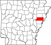 | |
| Towns | ||
| CDP | ||
| Other unincorporated communities | ||
| Footnotes | ‡This populated place also has portions in an adjacent county or counties | |
This article about a location in St. Francis County, Arkansas is a stub. You can help Wikipedia by expanding it. |