Nerskaya
| Nerskaya | |
|---|---|
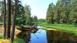
 Nerskaya river near Kurovskoye city | |
| Native name | Нерская (Russian) |
| Location | |
| Country | Russia |
| Physical characteristics | |
| Mouth | Moskva |
• coordinates | 55°21′21″N 38°36′05″E / 55.3559°N 38.6015°E |
| Length | 92 km (57 mi) |
| Basin size | 1,510 km2 (580 sq mi) |
| Basin features | |
| Progression | Moskva→ Oka→ Volga→ Caspian Sea |

The Nerskaya (Russian: Не́рская) is a river in Moscow Oblast, Russia. It is a left tributary of the Moskva. It is 92 km in length, with a drainage basin of 1,510 km².[1] Its average discharge is 8.3 m³/s.
The town of Kurovskoye is on the Nerskaya.
Ponor, Volnaya, Guslitsa, Sechenka and Sushenka are tributaries of the Nerskaya.[1]
References[edit]
- ^ a b «Река НЕРСКАЯ», Russian State Water Registry
