
Narrows, Oregon
Narrows, Oregon | |
|---|---|
_(harDA0016b).jpg) The Narrows channel and bridge | |
 Narrows  Narrows | |
| Coordinates: 43°16′44″N 118°57′43″W / 43.279°N 118.962°W | |
| Country | United States |
| State | Oregon |
| County | Harney |
| Elevation | 4,111 ft (1,253 m) |
| Time zone | UTC-8 (Pacific (PST)) |
| • Summer (DST) | UTC-7 (PDT) |
| ZIP code | 97721 |
| Area code(s) | 458 and 541 |
Narrows, or The Narrows, is an unincorporated community in Harney County, Oregon, United States.[1][2] It was started as a community in 1889 by Lewis B. Springer and Albert Hembree. A post office was established in August 1889 and Springer, the postmaster, named it after himself. In April 1892 the name was changed to Narrows and Hembree became postmaster. The post office operated until 1936,[2] and is now served by the New Princeton post office, zip code 97721.
Climate[edit]
According to the Köppen Climate Classification system, Narrows has a semi-arid climate, abbreviated "BSk" on climate maps.[3]
Education[edit]
Narrows is in Harney County School District 4 (Crane School, grades K-8) and Harney County Union High School District 1J (Crane Union High School).[4][5]
References[edit]
- ^ Oregon Hometown Locator
- ^ a b McArthur, Lewis A.; McArthur, Lewis L (2003) [1928]. Oregon Geographic Names. Portland, Oregon: Oregon Historical Society Press. pp. 689–690. ISBN 0-87595-277-1.
- ^ Climate Summary for Narrows, Oregon
- ^ "2020 CENSUS - SCHOOL DISTRICT REFERENCE MAP: Harney County, OR" (PDF). U.S. Census Bureau. p. 1(PDF p. 2/3). Retrieved March 11, 2024. (use South Harney Road at Frencglen Highway as a locator point) - Text list - Compare to the highway map.
- ^ "Harney County Sheet 5 of 11" (PDF). Oregon Department of Transportation. Retrieved March 11, 2024. - Narrows indicated on the map. Compare with school district map.
Municipalities and communities of Harney County, Oregon, United States | ||
|---|---|---|
| Cities | 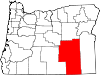 | |
| CDP | ||
| Other communities | ||
| Indian reservation | ||
| Ghost towns | ||
| Desert | ||
This Harney County, Oregon state location article is a stub. You can help Wikipedia by expanding it. |