
Mount Wardle
| Mount Wardle | |
|---|---|
 South aspect | |
| Highest point | |
| Elevation | 2,805 m (9,203 ft)[1] [2] |
| Prominence | 362 m (1,188 ft)[1] |
| Parent peak | Mount Verendrye (3,085 m)[1] |
| Isolation | 2.61 km (1.62 mi)[1] |
| Listing | Mountains of British Columbia |
| Coordinates | 50°57′33″N 116°01′12″W / 50.95917°N 116.02000°W[3] |
| Geography | |
 Mount Wardle Location of Mount Wardle in British Columbia  Mount Wardle Mount Wardle (Canada) | |
| Location | Kootenay National Park British Columbia, Canada |
| District | Kootenay Land District |
| Parent range | Vermilion Range Canadian Rockies |
| Topo map | NTS 82K16 Spillimacheen |
| Geology | |
| Age of rock | Cambrian[4] |
| Type of rock | Ottertail Limestone[4] |
| Climbing | |
| First ascent | 1922 |
Mount Wardle is a 2,805-metre (9,203-foot) mountain summit located in British Columbia, Canada.
Description[edit]
Mount Wardle is situated in Kootenay National Park at the southern end of the Vermilion Range, which is a sub-range of the Canadian Rockies. Mount Wardle is home to the largest population of mountain goats within the national park.[5] Topographic relief is significant as the summit rises 1,600 meters (5,250 feet) above the Banff–Windermere Highway in three kilometers (1.9 mile). Mount Wardle is composed of Ottertail limestone, a sedimentary rock laid down during the Cambrian period and pushed east and over the top of younger rock during the Laramide orogeny.[6] Precipitation runoff from the mountain drains east into Wardle Creek which is a tributary of the Vermilion River, and west into Lost Creek, a tributary of the Kootenay River.
History[edit]
The first ascent of the summit was made in 1922 by a Topographical Survey party.[7] The mountain's toponym was applied by Morrison P. Bridgland (1878–1948), a Dominion Land Surveyor who named many peaks in the Canadian Rockies.[8] It was officially adopted 9 September 1924 by the Geographical Names Board of Canada to honor James Morey Wardle (1888–1971), a highway design engineer and then-director of special projects for Parks Canada.[9] Wardle also served as superintendent of Banff National Park from 1919 through 1921.[10]
Climate[edit]
Based on the Köppen climate classification, Mount Wardle is located in a subarctic climate zone with cold, snowy winters, and mild summers.[11] Winter temperatures can drop below −20 °C with wind chill factors below −30 °C.
Gallery[edit]
-
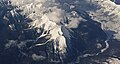 Aerial view of Mt. Wardle (centered), Mt. Verendrye (top, left) and Vermilion River (right)
 -
 Distant view looking north at Mt. Verendrye (center) and Mt. Wardle (right)


See also[edit]
References[edit]
- ^ a b c d "Mount Wardle, British Columbia". Peakbagger.com. Retrieved 2022-10-19.
- ^ AnneLise Sorensen, Christian Williams (2010), The Rough Guide to Canada, 7th edition, ISBN 978-1-84836-503-2, p. 690
- ^ "Mount Wardle". Geographical Names Data Base. Natural Resources Canada. Retrieved 2022-10-19.
- ^ a b Baird, David M. (1964). Kootenay National Park: Wild mountains and great valleys (PDF) (Report). Geological Survey of Canada. Miscellaneous Report 9. Retrieved 2020-01-06.
- ^ Bob Hahn (2000), Kootenay National Park, Rocky Mountain Books, ISBN 9780921102748, p. 67
- ^ Gadd, Ben (2008). Geology of the Rocky Mountains and Columbias.
- ^ "Mount Wardle". cdnrockiesdatabases.ca. Retrieved 2022-10-19.
- ^ MacLaren, I.S. (2005). Mapper of Mountains M.P. Bridgland in the Canadian Rockies 1902-1930. With Eric Higgs, Gabrielle Zezulka-Mailloux. Edmonton, AB: The University of Alberta Press. ISBN 0-88864-456-6.
- ^ "Mount Wardle". BC Geographical Names. Retrieved 2022-10-19.
- ^ Glen W. Boles, 2006, Mountain Place Names: The Rockies and Columbia Mountains, Rocky Mountain Books, ISBN 978-1-894765-79-4, p. 264
- ^ Peel, M. C.; Finlayson, B. L.; McMahon, T. A. (2007). "Updated world map of the Köppen−Geiger climate classification". Hydrol. Earth Syst. Sci. 11: 1633–1644. ISSN 1027-5606.
External links[edit]
- Weather: Mount Wardle
- Parks Canada web site: Kootenay National Park