
Mount Habel
| Mount Habel | |
|---|---|
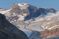
 Mount Habel seen from Peyto Lake Overlook | |
| Highest point | |
| Elevation | 3,073 m (10,082 ft)[1][2] |
| Prominence | 232 m (761 ft)[3] |
| Parent peak | Mount Baker (3180 m)[3] |
| Listing | |
| Coordinates | 51°38′55″N 116°34′17″W / 51.64861°N 116.57139°W[4] |
| Geography | |
 Mount Habel Location in Alberta and British Columbia  Mount Habel Mount Habel (British Columbia) | |
| Country | Canada |
| Provinces | Alberta and British Columbia |
| Protected area | Banff National Park |
| Parent range | Waputik Mountains |
| Topo map | NTS 82N10 Blaeberry River[4] |
| Climbing | |
| First ascent | 1923 A. Geoffrion, JWA Hickson, E. Feuz Jr.[2][3] |
Mount Habel is a 3,073-metre (10,082-foot) mountain summit located in Banff National Park on the Continental Divide along the border of Alberta and British Columbia in the Waputik Mountains, part of the Canadian Rockies. It was named in 1986 after Jean Habel.[2][3] Jean Habel was a German geographer who explored the Canadian Rockies and in 1897 was the first to set foot on the Wapta Icefield which surrounds Mount Habel.[5]
Geology[edit]
Like other mountains in Banff Park, Mount Habel is composed of sedimentary rock laid down during the Precambrian to Jurassic periods.[6] Formed in shallow seas, this sedimentary rock was pushed east and over the top of younger rock during the Laramide orogeny.[7]
Climate[edit]
Based on the Köppen climate classification, Mount Habel is located in a subarctic climate zone with cold, snowy winters, and mild summers.[8] Temperatures can drop below -20 °C with wind chill factors below -30 °C.
See also[edit]
Gallery[edit]
-
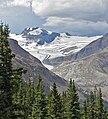
 Mt. Habel
 -
 Mount Habel from Peyto Lake overlook


References[edit]
- ^ "Topographic map of Mount Habel". opentopomap.org. Retrieved 2022-06-19.
- ^ a b c "Mount Habel". cdnrockiesdatabases.ca. Retrieved 2019-09-14.
- ^ a b c d "Mount Habel". Bivouac.com. Retrieved 2019-09-14.
- ^ a b "Mount Habel (BC)". Geographical Names Data Base. Natural Resources Canada. Retrieved 2019-09-14.
- ^ W., Boles, Glen (2006). Canadian mountain place names : the Rockies and Columbia Mountains. Laurilla, Roger W., 1959-, Putnam, William Lowell., Putnam, William Lowell. Place names of the Canadian Alps. Calgary, Alta.: Rocky Mountain Books. ISBN 9781894765794. OCLC 244770225.
{{cite book}}: CS1 maint: multiple names: authors list (link) - ^ Belyea, Helen R. (1960). The Story of the Mountains in Banff National Park (PDF). parkscanadahistory.com (Report). Ottawa: Geological Survey of Canada. Archived (PDF) from the original on 2015-10-02. Retrieved 2019-09-13.
- ^ Gadd, Ben (2008). Geology of the Rocky Mountains and Columbias.
- ^ Peel, M. C.; Finlayson, B. L.; McMahon, T. A. (2007). "Updated world map of the Köppen−Geiger climate classification". Hydrol. Earth Syst. Sci. 11: 1633–1644. ISSN 1027-5606.
External links[edit]
- Parks Canada web site: Banff National Park
- Mount Habel weather: Mountain Forecast