
McBrayer, Kentucky
McBrayer, Kentucky | |
|---|---|
 McBrayer, Kentucky | |
| Coordinates: 37°58′31″N 84°53′08″W / 37.97528°N 84.88556°W | |
| Country | United States |
| State | Kentucky |
| County | Anderson |
| Elevation | 833 ft (254 m) |
| Time zone | UTC-5 (Eastern (EST)) |
| • Summer (DST) | UTC-4 (EDT) |
| Area code | 502 |
| GNIS feature ID | 497764[1] |
McBrayer is an unincorporated community in Anderson County, Kentucky, United States.[1][2]
Notes[edit]
Municipalities and communities of Anderson County, Kentucky, United States | ||
|---|---|---|
| City | 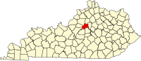 | |
| Unincorporated communities | ||
| Ghost town | ||
This Anderson County, Kentucky state location article is a stub. You can help Wikipedia by expanding it. |