
Matebian
| Matebian | |
|---|---|
| Matebean | |
 | |
| Highest point | |
| Elevation | 2,316 m (7,598 ft)[1] |
| Coordinates | 8°38′26.16″S 126°35′48.84″E / 8.6406000°S 126.5969000°E |
| Geography | |
 Matebian Location in East Timor | |
| Location | Baucau District, East Timor |
Matebian or Matebean is the third highest mountain in Timor Leste, after Ramelau (Tatamailau).
Geography[edit]
The mountain is located in Baucau District. With an elevation of 2,316 metres (7,598 ft) it is among the ultra-prominent peaks of the Malay Archipelago.
At the peak is a statue of Jesus.[2][3]
Gallery[edit]
-
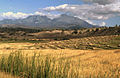 Harvested rice fields of Matebian, Timor-Leste
 -
 View across the Seiçal River to Matebian Mountain, East Timor
 -
 Matebian, East Timor


References[edit]
- ^ Timor Leste: Politics, History, and Culture, Andrea Katalin Molnar, Routledge, 2009, Google books Retrieved 2015-12-24
- ^ Matebean Mane, Climbing the Mountains of Indonesia. Retrieved 2014-04-11.
- ^ Around Baucau Archived 2014-04-13 at the Wayback Machine, Lonely Planet. Retrieved 2014-04-11.
![]() Media related to Matebian at Wikimedia Commons
Media related to Matebian at Wikimedia Commons
This mountain, mountain range, or peak related article is a stub. You can help Wikipedia by expanding it. |