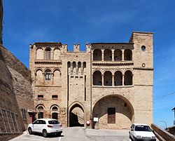
Massa Fermana
Massa Fermana | |
|---|---|
| Comune di Massa Fermana | |
 | |
| Coordinates: 43°9′N 13°28′E / 43.150°N 13.467°E | |
| Country | Italy |
| Region | Marche |
| Province | Fermo (FM) |
| Government | |
| • Mayor | Giampiero Tarulli |
| Area | |
| • Total | 7.7 km2 (3.0 sq mi) |
| Elevation | 340 m (1,120 ft) |
| Population (1 January 2008)[2] | |
| • Total | 970 |
| • Density | 130/km2 (330/sq mi) |
| Demonym | Massetani |
| Time zone | UTC+1 (CET) |
| • Summer (DST) | UTC+2 (CEST) |
| Postal code | 63020 |
| Dialing code | 0734 |
| Patron saint | St. Lawrence |
| Saint day | August 10 |
Massa Fermana is a comune (municipality) in the Province of Fermo in the Italian region Marche, located about 50 kilometres (31 mi) south of Ancona and about 35 kilometres (22 mi) northwest of Ascoli Piceno.
The parish church of Santi Lorenzo, Silvestro, e Ruffino houses the Massa Fermana Altarpiece (1468) by Carlo Crivelli. The St Anthony Gate dates to the 14th century.
In 1946, Ada Natali become mayor of this town, being the first female mayor in Italy's history.
References[edit]
- ^ "Superficie di Comuni Province e Regioni italiane al 9 ottobre 2011". Italian National Institute of Statistics. Retrieved 16 March 2019.
- ^ All demographics and other statistics: Italian statistical institute Istat.


