
Mareham Lane
Route map:
Mareham Lane is an unclassified road between Graby and Sleaford in Lincolnshire, England. It is approximately 10.6 miles (17.1 km) long.
The Roman Road[edit]
For most of its length Mareham Lane follows the route of a minor Roman road, and the name is also used for that Roman road from Bourne to the original ford at Sleaford[1] and perhaps on to Lincoln (Lindum Colonia).[2][3]
Margary numbers[edit]
Ivan Margary allocated the following Margary numbers in his classification scheme:[4]
- RR260 Bourne-Sleaford
- RR262 Sleaford-Bracebridge Heath
-
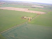 Beacon Hill farm on Mareham Lane
 -
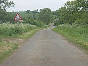
 Mareham Lane near Scredington
 -
 Ford just north of Graby
 -
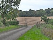 Roman Alignment through cornfield


.jpg)
Route details[edit]
| Point | Coordinates (Links to map resources) |
OS Grid Ref | Notes |
|---|---|---|---|
| Footpath to Cawthorpe | 52°46′53″N 0°22′37″W / 52.78136°N 0.37688°W | TF095216 | King street deviates from modern A15, to go through Stainfield to Ancaster. Start of Roman Mareham Lane |
| Old Beck culvert | 52°49′59″N 0°22′56″W / 52.833°N 0.382338°W | TF090273 | Bottom of Windmill Hill, Rippingale. Start of linear Roman alignment on OS map |
| Layby at Graby | 52°50′45″N 0°22′45″W / 52.84589°N 0.379076°W | TF092288 | Modern A15 straightened in the late 20th century. Roman alignment continues into lay-by |
| Footpath to Graby Lane | 52°50′52″N 0°22′42″W / 52.8479°N 0.37839°W | TF093290 | Roman alignment continues across field as public footpath |
| Graby Lane | 52°51′06″N 0°22′34″W / 52.85179°N 0.376201°W | TF094294 | End of footpath. Start of Modern Mareham Lane |
| Ford | 52°51′33″N 0°22′32″W / 52.85909°N 0.375624°W | TF094303 | |
| Dry Ford | 52°53′28″N 0°22′31″W / 52.891069°N 0.375180°W | TF094338 | Seasonally intermittent Stream, sometimes appears across road. Stream flows into Ouse Mere Lode |
| Billingborough crossroads | 52°53′35″N 0°22′34″W / 52.89308°N 0.37610°W | TF093340 | Billingborough road, Folkingham Folkingham road, Billingborough. |
| Stow Green | 52°54′08″N 0°22′29″W / 52.902246°N 0.374673°W | TF094351 | Site of Stow Fair. Site of Anglo-Saxon nunnery. |
| Threekinghham crossroads | 52°54′51″N 0°22′38″W / 52.914059°N 0.377324°W | TF092364 | Modern A52 crosses Modern Mareham Lane. |
| Mareham House | 52°55′43″N 0°22′45″W / 52.92864°N 0.379285°W | TF090380 | Road junction at Spanby |
| Bend | 52°58′51″N 0°23′14″W / 52.980883°N 0.387184°W | TF083438 | Northern end of Roman alignment on OS map. Modern road deviates, and Roman Alignment becomes unclear. |
| Corner | 52°59′21″N 0°23′28″W / 52.989179°N 0.391002°W | TF081447 | Modern Mareham road turns left. This different alignment continues toward the old ford at Sleaford as a footpath. |
| Parish boundary | 52°59′31″N 0°23′35″W / 52.992037°N 0.392937°W | TF079450 | Modified alignment continues past modern Mareham Lane as parish boundary Public footpath alongside. |
| Sleaford level crossing | 52°59′43″N 0°24′31″W / 52.995258°N 0.408493°W | TF069453 | End of modern road called Mareham Lane at Sleaford level crossing. |
| cropmark | 52°59′05″N 0°23′10″W / 52.984625°N 0.386017°W | TF084442 | Possible continuation of straight alignment after the bend[5] |
| cropmark | 52°59′50″N 0°23′08″W / 52.997205°N 0.385548°W | TF084456 | Well-founded discovery of Roman road not on expected alignment.[6] |
| Ruskington | 53°02′16″N 0°23′19″W / 53.037701°N 0.388510°W | TF081501 | Well-founded discovery of Roman road to south of Ruskington, on public footpath.[7] Speculative northern continuation from Sleaford to Lincoln |
See also[edit]
- High Dyke, Lincolnshire
- King Street (Roman road) Water Newton to Bourne to Ancaster, Margary number RR26
References[edit]
- ^ RR260: Margary, Ivan Donald (1973). Roman roads in Britain. J. Baker. p. 206. ISBN 978-0-212-97001-8.
- ^ Historic England. "Roman Road RR260 Bourne to Lincoln via Sleaford (1061192)". Research records (formerly PastScape). Retrieved 27 February 2011.
- ^ Historic England. "Roman Road RR262 Sleaford to Lincoln via Bracebridge Heath (1061215)". Research records (formerly PastScape). Retrieved 27 February 2011.
- ^ Margary, Ivan Donald. Roman roads in Britain.
- ^ Historic England. "Cropmark near bend in the road (1044205)". Research records (formerly PastScape). Retrieved 27 February 2011.
- ^ Historic England. "Cropmark to east of original alignment (1049491)". Research records (formerly PastScape). Retrieved 27 February 2011.
- ^ Historic England. "Cropmark on Footpath near Ruskington (1049494)". Research records (formerly PastScape). Retrieved 27 February 2011.
- Whitwell, J B (1992). Roman Lincolnshire. The Society of Lincolnshire History and Archaeology. ISBN 0-902668-16-1.
External links[edit]
KML is from Wikidata