Malidegao
Malidegao | |
|---|---|
| Municipality of Malidegao | |
 | |
| Country | Philippines |
| Region | Bangsamoro |
| Province | Cotabato |
| Founded | April 13, 2024 |
| Government | |
| • Mayor | Vacant |
| • Vice Mayor | Vacant |
| Area | |
| • Total | 115.45 km2 (44.58 sq mi) |
| Population (2002) | |
| • Total | 36,438 |
| • Density | 320/km2 (820/sq mi) |
| Time zone | UTC+8 (PST) |
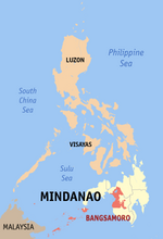
Malidegao, officially the Municipality of Malidegao (Maguindanaon: Inged nu Malidegao, Jawi: ; Hiligaynon: Banwa sang Malidegao; Cebuano: Lungsod sa Malidegao; Tagalog: Bayan ng Malidegao), is a municipality in the province of Cotabato, Philippines. The municipality is part of the Bangsamoro Autonomous Region in Muslim Mindanao despite Cotabato being part of Soccsksargen.
History[edit]
When the Bangsamoro was created in 2019 to supplant the Autonomous Region in Muslim Mindanao, 63 barangays in the province of Cotabato were grouped with the newer autonomous region in the second part of the plebiscite held in February 6.[1] The mother municipalities and Cotabato province remained part of Soccsksargen.[2]
By March 2020, these barangays were designated as a Special Geographic Area (SGA) of the Bangsamoro region.[3]
On August 17, 2023, the bills consolidating the SGA barangays into eight municipalities were approved by the Bangsamoro Parliament,[4] The particular bill creating Malidegao was Bangsamoro Autonomy Act No. 134.[5] The town was initially proposed to be named as Malmar, but this was changed to Madridagao (and later Malidegao) to better reflect the area's culture and heritage.[6]
A plebiscite was held on April 13, 2024, and voters approved all eight bills reconstituting the SGA barangays to eight municipalities including Malidegao, where 12,255 voted in favor of its creation while 44 voted against. The Bangsamoro regional government will provide P2.5 million in funding for the municipal government until it gets its share of income from the National Tax Allotment.[7] Malidegao was created from seven barangays of Pikit.[5]
Geography[edit]
Barangays[edit]
Malidegao is politically subdivided into seven barangays. Each barangay consists of puroks while some have sitios.
- Balungis
- Batulawan
- Fort Pikit
- Gokotan
- Nabundas
- Nalapaan
- Nunguan
Government[edit]
Officers-in-charge will be selected by BARMM Chief Minister Murad Ebrahim to fill positions in the municipal government pending regular elections in 2025. The municipality will also stay under the jurisdiction of the Special Geographic Area pending the creation of a new province.[8][9]
References[edit]
- ^ Santos, Tina (February 15, 2019). "63 Cotabato barangays now part of BARMM". Philippine Daily Inquirer. Retrieved May 22, 2019.
- ^ Layug, Margaret Claire (February 8, 2019). "What happens to Cotabato barangays not part of new Bangsamoro region?". GMA News (in English and Tagalog). Retrieved May 22, 2019.
- ^ Fernandez, Edwin (March 21, 2020). "BARMM records 2 Covid-19 deaths, 2 infected". Retrieved June 30, 2020.
- ^ "BARMM approves creation of 8 new towns". Manila Bulletin. Retrieved 19 August 2023.
- ^ a b "Bills creating 8 municipalities in SGA-BARMM approved by BTA Parliament". Luwaran. 20 August 2023. Retrieved 25 August 2023.
- ^ "Constituents unite in support of establishing municipalities in BARMM Special Geographic Area". Bangsamoro Parliament. June 11, 2023. Retrieved June 13, 2023.
- ^ Bolledo, Jairo (13 April 2024). "BARMM residents approve creation of 8 more towns". Rappler. Retrieved 13 April 2024.
- ^ "81% voter turnout on BARMM special geographic area plebiscite". Daily Tribune. 14 April 2024. Retrieved 14 April 2024.
- ^ "BARMM eyes new province for eight newly created towns". Rappler. 16 April 2024. Retrieved 16 April 2024.

