Maira Valley
| Maira Valley | |
|---|---|
| Val Maira, Valle Macra | |
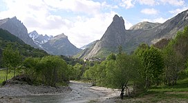
 The highest part of the valley | |
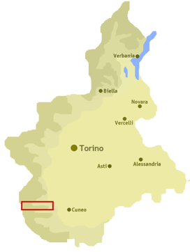
 Location of the valley in Piedmont, NW Italy | |
| Floor elevation | 500–3,412 m (1,640–11,194 ft) |
| Length | around 45 km (28 mi) west east |
| Geology | |
| Type | River valley |
| Geography | |
| Location | Piedmont, Italy |
| Coordinates | 44°30′07″N 7°08′16″E / 44.50194°N 7.13778°E |
Maira Valley (in Italian Val Maira or Valle Macra) is a valley in south-west of Piedmont in the Province of Cuneo, Italy.
Etymology[edit]
The valley takes its name from the river Maira, a right-hand tributary of the Po which flows through the valley.
Geography[edit]
The municipalities of the valley are Busca, Villar San Costanzo, Dronero, Roccabruna, Cartignano, San Damiano Macra, Macra, Celle di Macra, Stroppo, Elva, Canosio, Marmora, Prazzo and Acceglio.[1]
Notable summits[edit]
Among the notable summits which surround the valley (all of them belonging to the Cottian Alps) there are:
- Monte Oronaye - 3100 m
- Buc de Nubiera - 3215 m
- Brec de Chambeyron - 3412 m
- Tête de la Frema - 3143 m
- Monte Chersogno - 3026 m
- Pelvo d'Elva - 3064 m
- Rocca la Marchisa - 3072 m
- Monte Maniglia - 3177 m
- Rocca la Meja - 2831 m
- Punta Tempesta - 2679 m
- Monte Birrone - 2131 m
See also[edit]
Notes and references[edit]
External links[edit]
Wikimedia Commons has media related to Maira Valley.
- http://www.valligranaemaira.it/ (in Italian)
