
Lockport Township, Haskell County, Kansas
Lockport Township | |
|---|---|
 Location in Haskell County | |
| Coordinates: 37°34′45″N 100°43′02″W / 37.57917°N 100.71722°W | |
| Country | United States |
| State | Kansas |
| County | Haskell |
| Area | |
| • Total | 192.44 sq mi (498.42 km2) |
| • Land | 192.26 sq mi (497.96 km2) |
| • Water | 0.18 sq mi (0.46 km2) 0.09% |
| Elevation | 2,877 ft (877 m) |
| Population (2000) | |
| • Total | 522 |
| • Density | 2.7/sq mi (1/km2) |
| GNIS feature ID | 0485197 |
Lockport Township is a township in Haskell County, Kansas, USA. As of the 2000 census, its population was 522.
Geography[edit]
Lockport Township covers an area of 192.44 square miles (498.4 km2) and contains no incorporated settlements. According to the USGS, it contains one cemetery, Colusa.
References[edit]
External links[edit]
Municipalities and communities of Haskell County, Kansas, United States | ||
|---|---|---|
| Cities | 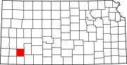 | |
| Unincorporated communities |
| |
| Ghost towns | ||
| Townships | ||
This article about a location in Haskell County, Kansas is a stub. You can help Wikipedia by expanding it. |