Lapės Eldership
Lapės Eldership
Lapių seniūnija | |
|---|---|
 Road to Lapės | |
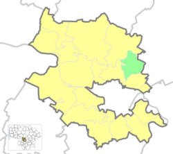
 Location of Lapės Eldership | |
| Coordinates: 55°00′32″N 24°01′37″E / 55.009°N 24.027°E | |
| Country | |
| Ethnographic region | Aukštaitija |
| County | Kaunas County |
| Municipality | Kaunas District Municipality |
| Administrative centre | Lapės |
| Area | |
| • Total | 57 km2 (22 sq mi) |
| Population (2021)[1] | |
| • Total | 3,547 |
| • Density | 62/km2 (160/sq mi) |
| Time zone | UTC+2 (EET) |
| • Summer (DST) | UTC+3 (EEST) |
Lapės Eldership (Lithuanian: Lapių seniūnija) is a Lithuanian eldership, located in the eastern part of Kaunas District Municipality.
References[edit]
- ^ "2021 census". Statistikos Departamentas (Lithuania). Retrieved November 10, 2021.
