
Lanta, Haute-Garonne
Lanta | |
|---|---|
 The town hall in Lanta | |
.svg) Coat of arms | |
Location of Lanta  | |
 Lanta  Lanta | |
| Coordinates: 43°33′37″N 1°39′20″E / 43.5603°N 1.6556°E | |
| Country | France |
| Region | Occitania |
| Department | Haute-Garonne |
| Arrondissement | Toulouse |
| Canton | Revel |
| Government | |
| • Mayor (2022–2026) | Rémi Diaz[1] |
| Area 1 | 30.12 km2 (11.63 sq mi) |
| Population (2021)[2] | 2,220 |
| • Density | 74/km2 (190/sq mi) |
| Time zone | UTC+01:00 (CET) |
| • Summer (DST) | UTC+02:00 (CEST) |
| INSEE/Postal code | 31271 /31570 |
| Elevation | 159–275 m (522–902 ft) (avg. 230 m or 750 ft) |
| 1 French Land Register data, which excludes lakes, ponds, glaciers > 1 km2 (0.386 sq mi or 247 acres) and river estuaries. | |
Lanta (French pronunciation: [lɑ̃ta]; Occitan: Lantar) is a commune in the Haute-Garonne department in southwestern France.
History[edit]
The attempt of the capitoul Pierre Hunault, sieur de Lanta, to seize control of Toulouse's Capitol was the immediate cause of the 1562 riots there.
Population[edit]
| Year | Pop. | ±% p.a. |
|---|---|---|
| 1968 | 874 | — |
| 1975 | 908 | +0.55% |
| 1982 | 1,026 | +1.76% |
| 1990 | 1,144 | +1.37% |
| 1999 | 1,175 | +0.30% |
| 2007 | 1,483 | +2.95% |
| 2012 | 1,775 | +3.66% |
| 2017 | 2,070 | +3.12% |
| Source: INSEE[3] | ||
Monument[edit]
-
 The bell gable
 -
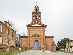 The Church of Our Lady of Lanta
 -
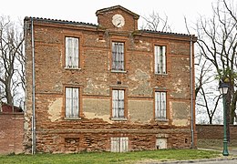 The facade of the old rectory.
 -
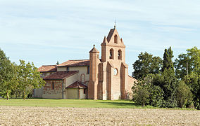 Lanta - Saint Anatoly
 -
 Saint Anatoly de Lanta
 -
 Dovecote.


See also[edit]
References[edit]
- ^ "Répertoire national des élus: les maires" (in French). data.gouv.fr, Plateforme ouverte des données publiques françaises. 6 June 2023.
- ^ "Populations légales 2021". The National Institute of Statistics and Economic Studies. 28 December 2023.
- ^ Population en historique depuis 1968, INSEE
Wikimedia Commons has media related to Lanta.
This Haute-Garonne geographical article is a stub. You can help Wikipedia by expanding it. |