
Laisterdyke railway station
Laisterdyke | |
|---|---|
 Former location of Laisterdyke railway station, looking east from Laisterdyke overbridge. | |
| General information | |
| Location | Bradford, City of Bradford England |
| Coordinates | 53°47′29″N 1°42′59″W / 53.7914°N 1.7165°W |
| Grid reference | SE187328 |
| Platforms | 4 |
| Other information | |
| Status | Disused |
| History | |
| Pre-grouping | Great Northern Railway |
| Key dates | |
| 1 August 1854 | opened |
| 4 July 1966 | closed |
Laisterdyke railway station is a closed station in the city of Bradford, West Yorkshire, England,[1] that served the suburb of the same name.
History[edit]
The station was opened on 1 August 1854[2] on the Leeds, Bradford and Halifax Junction Railway's Leeds to Bradford Adolphus Street line. Three years later, a second route from the station to Ardsley via Dudley Hill and Morley (Top) was opened by the same company, making the station a junction of some importance. Further construction by the ambitious Great Northern led to the addition of branches to Wakefield via Adwalton and Batley in 1864, Shipley in 1875 and Pudsey (Greenside) in 1893.[3] The facilities provided here were consequently quite generous, with four platforms, two signal boxes and a sizeable goods yard.[4] The branch to Shipley was an early casualty of road competition, losing its passenger service in February 1931. The other routes survived to be taken into British Railways ownership upon nationalisation in 1948. Both, however, succumbed to the Beeching Axe in the mid-1960s, with services on the Pudsey Loop and to Wakefield via Batley services ending in 1964, and those via Ardsley to Wakefield Westgate following suit two years later.

The station was closed to passengers on 4 July 1966, on the same day as the line to Ardsley.[5] The platforms were subsequently demolished.[6] Only the station house remains on the top of the cutting south of the tracks, and a siding serves a scrap yard west of the former passenger station.[7]
Route[edit]
| Preceding station | Disused railways | Following station | ||
|---|---|---|---|---|
| Bradford Adolphus Street or St Dunstans or Manchester Road or Bowling |
Great Northern Railway | Dudley Hill or Pudsey Greenside | ||
| St Dunstans | Great Northern Railway Shipley Great Northern Railway branch line |
Eccleshill |
References[edit]
- ^ Bairstow, Martin (1987). The Manchester and Leeds Railway: The Calder Valley Line. Halifax: Martin Bairstow. p. 28. ISBN 1-871944-22-8.
- ^ "Bradford Timeline - History of Bradford, Yorkshire, 1850-1899". Retrieved 17 June 2009.
- ^ GNR BRADFORD (LAISTERDYKE EAST JN) - SHIPLEY (6 miles) Railway Ramblers Gazetteer of Disused Railways in West Yorkshire; Retrieved 21 January 2016
- ^ Laisterdyke station in 1954Telegraph & Argus; Retrieved 21 January 2016
- ^ "Closure Dates Of West Yorkshire Railway Passenger Stations". Retrieved 17 June 2009.
- ^ Laisterdyke Railway station site (Yorkshire) Thompson, Nigel; Geograph.org; Retrieved 21 January 2016
- ^ Martin Latus. "Bowling to Laisterdyke. A Bradford railway history". Retrieved 4 July 2017.
External links[edit]
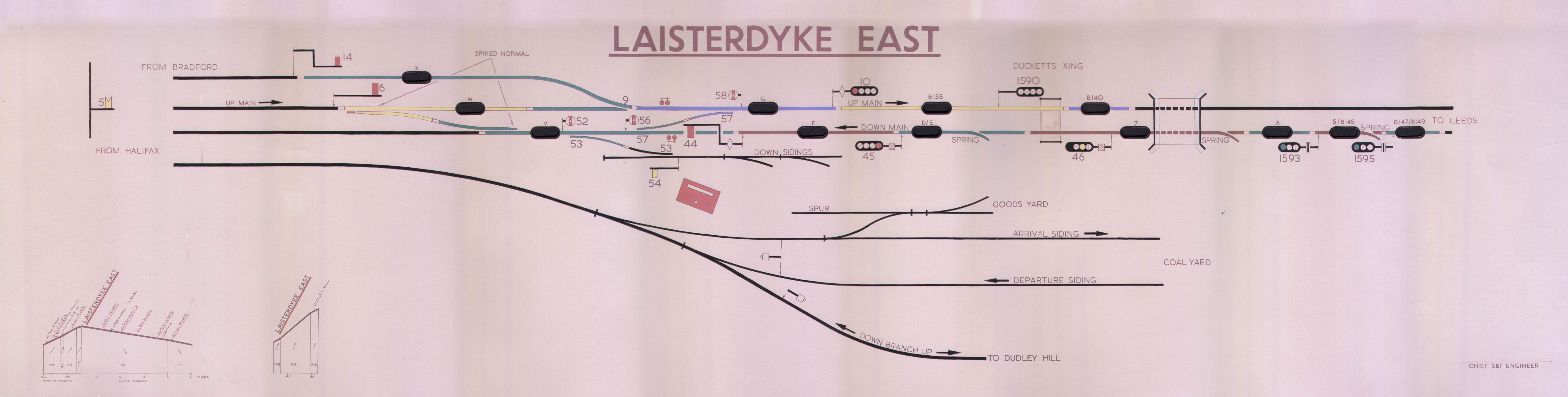
- Laisterdyke East Signal Box diagram
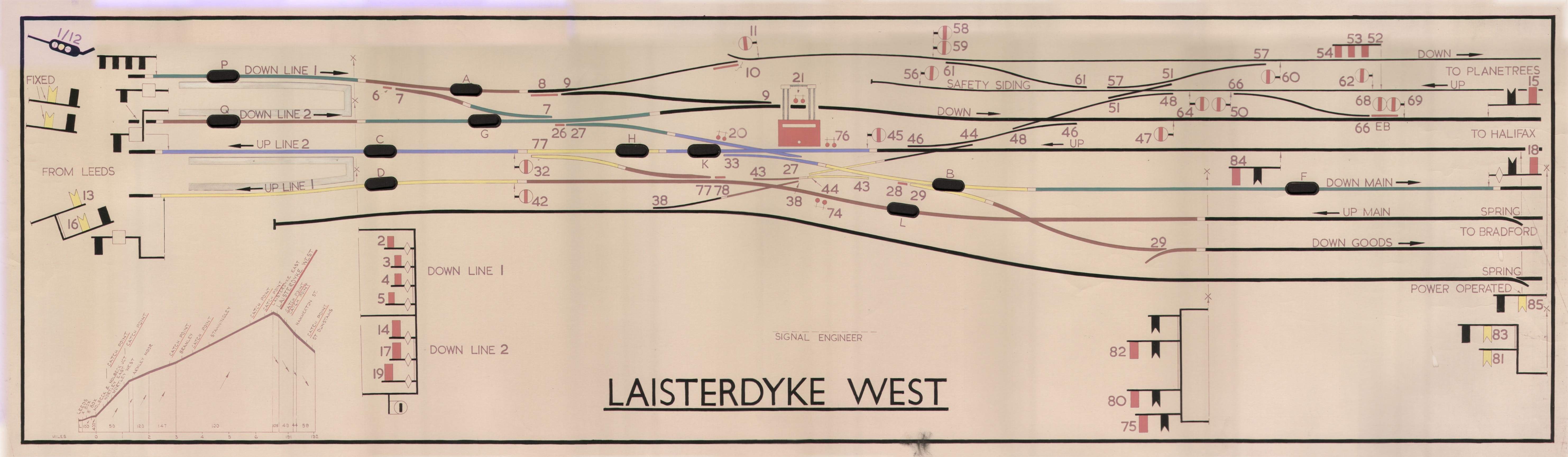
- Laisterdyke West Signal Box diagram
- Lost Railways of West Yorkshire - Pudsey Loop
This article on a railway station in Yorkshire and the Humber is a stub. You can help Wikipedia by expanding it. |