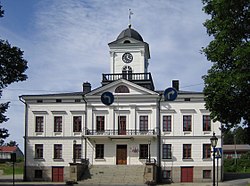
Kristinestad City Hall
| Kristinestad city hall | |
|---|---|
Kristinestads rådhus / Kristiinankaupungin raatihuone | |
 City hall in 2018 | |
 | |
| General information | |
| Type | Public |
| Architectural style | Neoclassical |
| Town or city | Kristinestad |
| Country | Finland |
| Coordinates | 62°16′28″N 21°22′24″E / 62.2744°N 21.3733°E |
| Current tenants | City of Kristinestad |
| Completed | 1865 |
| Technical details | |
| Material | Masonry |
| Floor count | 2 (above ground) + tower |
| Design and construction | |
| Architect(s) | Ernst Lohrmann |
Kristinestad City Hall (Swedish: Kristinestads rådhus, Finnish: Kristiinankaupungin raatihuone) is the municipal headquarters building of Kristinestad (Kristiinankaupunki) on the west coast of Finland.[1] The present city hall is the fourth in Kristinestad.[1]
The building was designed in the neoclassical style by a leading architect of public buildings in the mid-19th century Finland, Ernst Lohrmann, and completed in 1865.[2] It is of masonry construction, and comprises two storeys with a central clock tower.[2]
References[edit]
- ^ a b "Landmarks". VisitKristinestad.fi. City of Kristinestad. Retrieved 22 May 2021.
- ^ a b "Kristiinankaupungin ruutukaava-alue". RKY.fi (in Finnish). Finnish Heritage Agency. Retrieved 22 May 2021.
