
Joint valley landscape
.jpg)
Joint valley landscape or fissure valley terrain (Swedish: sprickdalslandskap, sprickdalsterräng) is a type of relief common in Fennoscandia. The landscape originates from the erosion of joints in the bedrock which leaves out small plateaus or ridges in between.[1] When the block summits in joint valley landscape are of different height it may indicate the past movement of a vertical geological fault.[1]
Karna Lidmar-Bergström identified joint valley landscape areas centered on Blekinge, Bohuslän, Linköping/Västervik, Stockholm and Hudiksvall. In the last three areas the flat summits of the landscapes are parts of the Sub-Cambrian peneplain. In addition to this there is a large-scale joint valley landscape that extends from the High Coast inland.[2] The landscape type was first identified by Sten De Geer who in 1926 called it rutplatåland (lit. square plateau land).[3][4] Joint valley landscapes are among the few places in southern Sweden where there are steep slopes in excess of 25°.[5]
Gallery[edit]
-
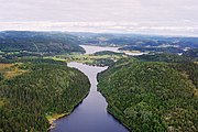 Large scale joint valley landscape at The High Coast, Ångermanland.
 -
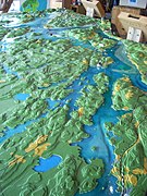 Model of the joint valley landscape around lake Sommen in naturum Sommen.


References[edit]
- ^ a b Terrängformer i Norden (in Swedish). Nordiska ministerrådet. 1984. p. 9.
- ^ Lidmar-Bergströrm, Karna (1995). "Relief and saprolites through time on the Baltic Shield". Geomorphology. 12. Elsevier: 45–61.
- ^ De Geer, Sten (1926). "Norra Sveriges landforms-regioner". Geografiska Annaler (in Swedish). 8. Swedish Society for Anthropology and Geography: 125–136.
- ^ "Regionindelning". Utredning angående Norrlands näringsliv. Förberendade undersökning verkställd av 1940 års norrlandsutredning. Statens offentliga utreningar (in Swedish). Vol. 39. Stockholm: Jordbruksdepartamentet. 1943. p. 21.
- ^ Rudberg, Sten (1997). "Sweden". In Embleton, C.; Embleton-Hamann, C. (eds.). Geomorphological Hazards of Europe. Elsevier. p. 457.