Jamboree Park
| Jamboree Park | |
|---|---|
| Agrabad Jamboree Park | |
| Bengali: জাম্বুরী পার্ক | |
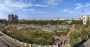
 Panoramic view of Jamboree park with Agrabad commercial area in background | |
 | |
| Type | Urban park |
| Location | Agrabad, Chittagong |
| Coordinates | 22°19′27″N 91°48′32″E / 22.32417°N 91.80885°E |
| Area | 8.55 acres (0.0346 km2) |
| Created | 2018 |
| Owned by | Ministry of Housing and Public Works |
| Operated by | Ministry of Housing and Public Works |
| Visitors | 1000+ |
| Open | 17:00 to 21:00 (BST) |
| Status | Open all year |
| Paths | 8,000 feet (2,400 m) |
| Water | 50,000 square feet (4,600 m2) |
Jamboree Park (also spelled as Jamburi Park) is an urban park in the Agrabad area of Chittagong, Bangladesh.[1] The park has 50,000 square feet (4,600 m2) water-body alongside 8,000 feet (2,400 m) walkway and compound road, internal master drain.[2]
Location[edit]
It is located at SM Morshed Road and the most visited urban park in the port city. The park was established in 2018 on 8.55 acres (3.46 ha)[3] of land acquired by the city.[1]
Gallery[edit]
-
Aerial view
References[edit]
- ^ a b Amir Hasan Shahriar (September 8, 2018). "Jamboree playground turns park". The Daily Star. Archived from the original on 12 September 2018. Retrieved 9 September 2018.
- ^ "Eye-catching Jamboree Park opens in Ctg". New Age. 9 September 2018. Archived from the original on 19 November 2018. Retrieved 27 April 2019.
- ^ Rabin, Chowdhury (10 September 2018). "Jamboree Park". Daily Sun. Archived from the original on 19 July 2019. Retrieved 19 July 2019.
External links[edit]
Wikimedia Commons has media related to Jamboree Park.

