
Herman Brosius
Herman Brosius | |
|---|---|
| Born | 1851 Milwaukee, Wisconsin, U.S. |
| Died | 1917 (aged 65–66) |
| Nationality | American |
| Occupation | Cartography |
Herman Brosius (1851 - 1917) was an American cartographer who made panoramic maps that were printed at his twin brother Frederick Brosius' firm in Milwaukee, Wisconsin. His work is held in the collection of the Library and Archives Canada, Brock University,[1] and the Museum of Wisconsin Art.
Brosius was born in Milwaukee, Wisconsin.[2] His twin brother Frederick owned the Milwaukee Lithograph and Engraving Company and the brothers collaborated to produce dozens of panoramic maps.[2] Brosius produced several views of Texas municipalities beginning with Jefferson, Texas in 1872 [3]
His earliest map was of Darlington, Wisconsin. During his career, he also produced views of Canadian cities including Ontario[4] and Ottawa.
Brosius died in Milwaulkee.[2]
Gallery[edit]
-
 Ottawa, Canada 1876
 -
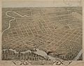
 Dallas, Texas 1872
 -
 Victoria, Texas 1873
 -
 Belleville, Ontario, Canada 1874
 -
 Jefferson, Texas 1872
_(39057460594).jpg)


.jpg)

References[edit]
- ^ "St. Catharines, 1875, Province Ontario, Canada". Brock University. 1875. Retrieved 29 August 2019.
- ^ a b c "Herman Brosius | MOWA Online Archive". wisconsinart.org.
- ^ "AMON CARTER MUSEUM: TEXAS BIRD'S-EYE VIEWS: BROWSE". www.birdseyeviews.org.
- ^ "Herman Brosius - Artist, Fine Art Prices, Auction Records for Herman Brosius". www.askart.com.
| International | |
|---|---|
| National | |
| People | |