Hensonville, New York
Hensonville, New York | |
|---|---|
| Coordinates: 42°17′23″N 74°13′00″W / 42.28972°N 74.21667°W | |
| Country | United States |
| State | New York |
| County | Greene |
| Town | Windham |
| Elevation | 1,637 ft (499 m) |
| Time zone | UTC-5 (Eastern (EST)) |
| • Summer (DST) | UTC-4 (EDT) |
| ZIP code | 12439 |
| Area code | 518 |
| GNIS feature ID | 952612[1] |
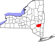
Hensonville is a hamlet in the town of Windham, Greene County, United States.[1] The zipcode is: 12439. The hamlet is the setting of Windham Town Hall, located at 371 NY-296, Hensonville, NY 12439.[2]
Notes[edit]
- ^ a b "Hensonville, New York". Geographic Names Information System. United States Geological Survey, United States Department of the Interior.
- ^ United States Postal Service (2012). "USPS - Look Up a ZIP Code". Retrieved February 15, 2012.


